Its Thursday the 30th of August and the plan today was to visit Berwick Upon Tweed and Edinburgh. I weighed up my options and I decided to drive to Berwick and get the train to Edinburgh. A ticket costing £29.70 for myself and my son off peak return was probably cheaper than driving 150 miles and paying to park, not to mention quicker than driving an hour and a half each way compared to 40 mins each way by train. Oh and no stressful city driving either!
So we arrived in Berwick and parked in the Castlegate Long stay car park which is free.
The name "Berwick" is of Old English origin, and is derived from the term bere-wīc, combining bere, meaning "barley", and wīc, referring to a farm or settlement. "Berwick" thus means "barley village" or "barley farm".

Berwick was founded as an Anglo-Saxon settlement during the time of the Kingdom of Northumbria, which was annexed by England in the 10th century. The area was for more than 400 years central to historic border wars between the Kingdoms of England and Scotland, and several times possession of Berwick changed hands between the two kingdoms. The last time it changed hands was when England retook it in 1482. Berwick remains a traditional market town and also has some notable architectural features, in particular its medieval town walls, its Elizabethan ramparts and Britain's earliest barracks buildings (1717–21 by Nicholas Hawksmoor for the Board of Ordnance).

We walk out onto Castlegate and turn right to head towards the station.

We bought our tickets and head down to the platform, only to be told that the next train our tickets weren't valid for(you need to check!) and the next train wasn't due for 21 minutes.
 |
| So it appears they built this station on the site of Berwick castle. |
The castle was founded in the 12th century by the Scottish King David I. In 1296–8, the English King Edward I had the castle rebuilt and the town fortified, before it was returned to Scotland. In November 1292, King Edward announced in the great hall before the full parliament of England and many of the nobility of Scotland his adjudication in favour of John Balliol of the dispute between him, Robert the Bruce and the count of Holland for the Crown of Scotland. 1330 "Domino Roberto de Lawedre" of the Bass, described as Custodian or Keeper of the Marches and the Castle of Berwick-upon-Tweed, received, apparently upon the termination of his employment there, £33.6s.8d, plus a similar amount, from the Scottish Exchequer.The town and castle changed hands several times during the English-Scottish conflicts.
The construction of modern ramparts around Berwick in the sixteenth century rendered the castle obsolete and its later history is one of steady decline. Large parts of the structure were simply used as a quarry (notably for the construction during the Commonwealth of the parish church, Holy Trinity), while in the nineteenth century, the great hall and much of what remained was demolished to make way for Berwick-upon-Tweed railway station. The railway platforms now stand where King Edward took oaths of allegiance from Scottish nobility in 1296, marked by a large notice to that effect.

With a wait needed, we head out to look at Berwick around the station. So we walked down into Castle Vale Park.


Royal Border Bridge spans the River Tweed between Berwick-upon-Tweed and Tweedmouth in Northumberland. It is a Grade I listed railway viaduct built between 1847 and 1850, when it was opened by Queen Victoria. The engineer who designed it was Robert Stephenson (son of railway pioneer George Stephenson). It was built for the York, Newcastle and Berwick Railway and is still in regular use today, as part of the East Coast Main Line. Despite its name, the bridge does not in fact span the border between England and Scotland, which is approximately three miles further north.

The bridge is 659 metres (2,162 ft) long and constructed in stone except for brick soffits to the arches. It has 28 arches, each spanning 60 feet (18 m). The railway is carried 37 metres (121 ft) above the river level. During 1989, it was electrified as a part of the wider East Coast Main Line electrification scheme. Between 1993 and 1996, the structure underwent significant repair work for the first time in a Railtrack-led project, which was partially funded by English Heritage.

The bridge was opened by Queen Victoria and Prince Albert on 29 August 1850, when she also granted her permission for it to be named the Royal Border Bridge.


 |
| Berwick Town Walls |
Berwick's town walls were built in the early 14th century under Edward I, following his capture of the city from the Scots. When complete they stretched 2 miles in length and were 3 feet 4 inches thick and up to 22 feet high, protected by a number of smaller towers, up to 60 feet tall. They were funded by a muragegrant in 1313, a tax on particular goods imported into the town. By 1405, however, the walls had fallen into considerable disrepair and were incapable of preventing Henry IV from taking the town with relative ease.
Berwick Castle (an earlier structure) lay just outside the medieval wall to the north-west, and was connected to the town by a bridge leading to a gate in the wall.

Today the walls are, in the view of archaeologists Oliver Creighton and Robert Higham, "by some measure the best-preserved example of town defences in Britain designed for post-medieval warfare". They are protected as a scheduled monument and a grade I listed building.


We arrive back at the station and board the Virgin train, George was very impressed with the posh train! He was even more impressed when I returned with drinks from the onboard refreshment bar.

After 40 minutes we pull into Edinburgh Old Town Station.

We leave the station and over the bridge onto Princes Street.

We come up to the Scott Monument in Princes Street Gardens East
On the death of Sir Walter Scott in 1832, the great and good of the city came together to agree on a fitting monument to this outstanding Scottish literary figure.
In 1836, an architectural competition was launched, inviting designs for an appropriate memorial. Two years later, the trustees approved the design submitted by George Meikle Kemp, and construction began in 1840.

Sitting proudly at the base of the monument is Sir Walter himself, carved in Carrara marble by Sir John Steell. This monumental statue, fashioned from a single piece of marble weighing 30 tons, took the sculptor six years to complete. It features Scott and his beloved hound Maida.


David Livingstone Statue in LocationEast Princes Street Gardens.
David Livingstone was born in 1813 in Blantyre, Lanarkshire. In 1840, he was ordained as a missionary and sent to South Africa, where he discovered the Victoria Falls. He died in 1873 while searching for the source of the Nile, and is buried in Westminster Abbey. The statue shows him holding a Bible, wearing a cloak and haversack, with a pistol and compass at his waist. The cast off lion skin represents him having survived a mauling. Sculpted by Amelia Paton Hill, (1820 - 1904) one of the few women sculptors in 19th century Edinburgh.
 |
| Princes Street,Edinburgh |

We enter Princes Street Garden East next to the Scott Monument.


Opposite is the Edinburgh Wheel.
The iconic red and white Ferris wheel returns to the heart of the city centre, offering spectacular views across Edinburgh and beyond.
See the city for the first time from 42meters in the air.

Tickets on the day
£9.50 per person
£7.50 concessions
£29 family ticket (4 people, max. 2 adults & min of 1 adult)

 |
| View up to Edinburgh Castle |


We pass The Scottish National Galleries.


 |
| PLAYFAIR STEPS Opened by then Lord Provest Kennith Borthwick on 21st April 1978. The Playfair steps pay homage to architect William Henry Playfair 1789 -1857. Leading from the top of Market Street down to the square at the Mound, The Art Galleries, Princes Street and Princes Street Gardens. |
We walk up Playfair Steps to The Mound.
 |
| New College University of Edinburgh |
 | |||||||||
| Black Watch War Memorial William Birnie Rhind, RSA, 1873-1933 Unveiled 1910 Bronze on a polished red granite base with the Black Watch crest above a bronze relief and bronze lettering Junction of North Bank Street and Market Street, the Mound, Edinburgh |


We now walk up Ramsey Lane and up to Camera Obscura and World of Illusions.


We now stroll down Castlehill onto The Royal Mile.
The Royal Mile runs through the heart of Edinburgh’s Old Town, connecting the magnificent Edinburgh Castle, perched high on a base of volcanic rock, with the splendorous Palace of Holyroodhouse, resting in the shadow of Arthur's Seat. The Mile is overlooked by impressive, towering tenements, between which cobbled closes and narrow stairways interlock to create a secret underground world.
 |
| An iconic landmark on the Edinburgh skyline, The Hub towers over the old town in the heart of the festival city, and is set on the historic Royal Mile between Edinburgh Castle and Holyrood Palace. |
We walk down a small alleyway to somewhere called "The Witchery by The Castle" and George says "Oh it's just a pub" A woman appears from nowhere and say actually its a restaurant. Looked a bit too posh and expensive for us!
 |
| Located in a sixteenth-century merchant's house, the rich baroque surroundings of the Witchery's original dining room offers one of the city's most exceptional and memorable dining destinations. Dine on red leather seats, surrounded by ancient oak panelling hung with tapestries. Heraldic painted ceilings recalling the Auld Alliance and Edinburgh's Royal past are reflected in the candlelight of dozens of antique candlesticks, whilst historic stone walls remind of the building's four hundred years of history. |


The Hub is now a unique and flexible venue, yet it also holds its place within the architectural fabric of Edinburgh and is a historic, category A listed building. The Hub’s spire is the highest point in central Edinburgh.
Built between 1842 and 1845, as the Victoria Hall, to house the General Assembly of the Church of Scotland, the building was created by architects: James Gillespie Graham and Augustus Welby Pugin. Curiously the building was never consecrated as a Church. In 1929 the Church of Scotland ceased to use the building and it became a temporary home for a variety of congregations. It was named the Highland Tolbooth St John’s Church in 1956, before falling into disuse in the 1980s.

In 1999, the building underwent a transformation to create offices and a performance space for the Edinburgh International Festival. The building is a stunning combination of award winning contemporary design and classic Victorian architecture.
As well as accommodating various events during the International Festival each year, The Hub offers a truly unique and spectacular space available to hire for creating conferences, banquets or gala dinners, weddings, meetings and exhibitions.


We walk up Johnston Terrace towards The Castle.

Now up some steps on Castle Wynd North to The Royal Mile and into the old training drill ground where the stands were being dismantled from last weeks Royal Edinburgh Military Tattoo.

We now come to Edinburgh Castle.
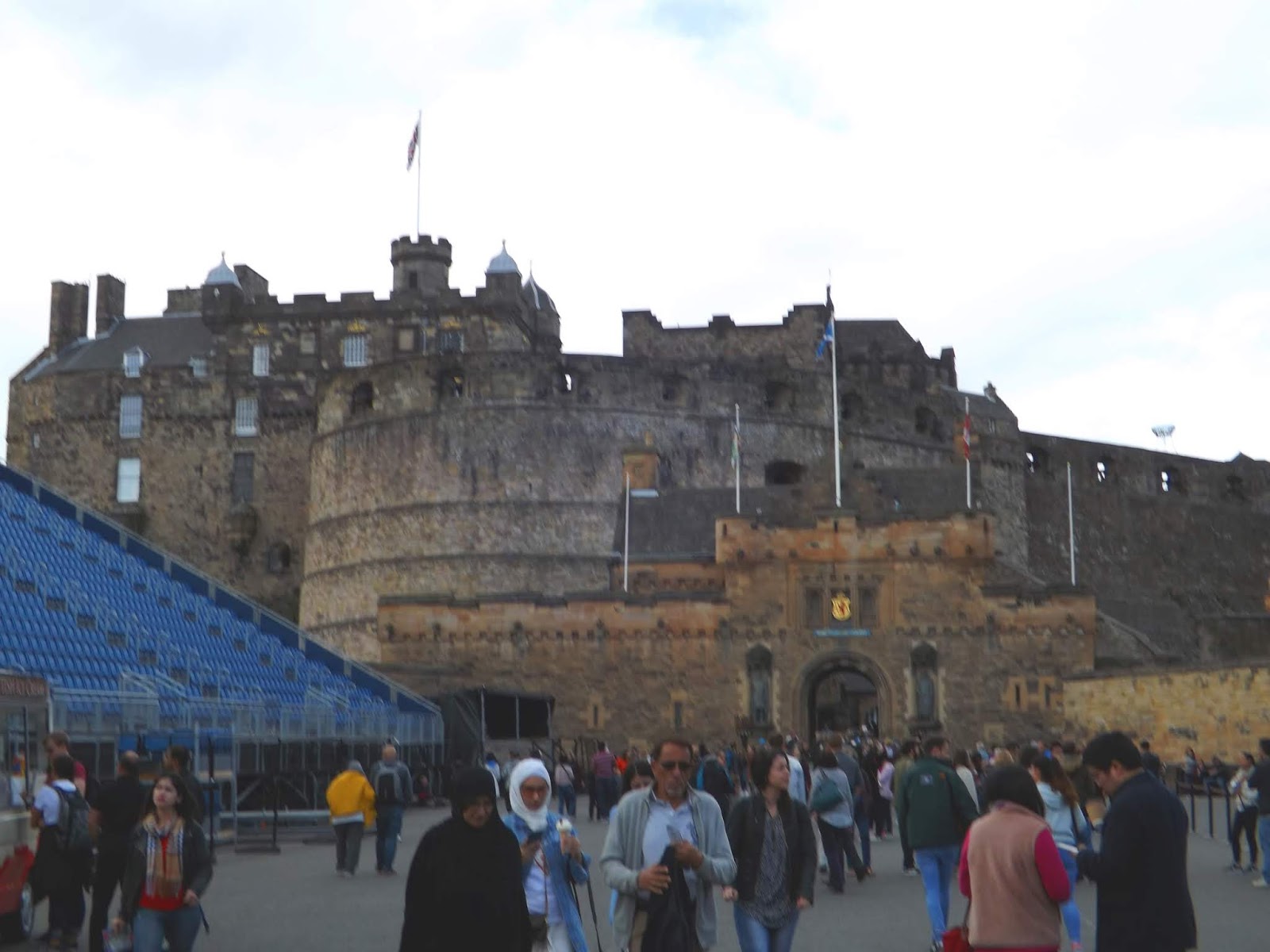
Edinburgh Castle is a historic fortress which dominates the skyline of the city of Edinburgh, Scotland, from its position on the Castle Rock. Archaeologists have established human occupation of the rock since at least the Iron Age (2nd century AD), although the nature of the early settlement is unclear. There has been a royal castle on the rock since at least the reign of David I in the 12th century, and the site continued to be a royal residence until 1633. From the 15th century the castle's residential role declined, and by the 17th century it was principally used as military barracks with a large garrison. Its importance as a part of Scotland's national heritage was recognised increasingly from the early 19th century onwards, and various restoration programmes have been carried out over the past century and a half. As one of the most important strongholds in the Kingdom of Scotland, Edinburgh Castle was involved in many historical conflicts from the Wars of Scottish Independence in the 14th century to the Jacobite rising of 1745. Research undertaken in 2014 identified 26 sieges in its 1100-year-old history, giving it a claim to having been "the most besieged place in Great Britain and one of the most attacked in the world".

The castle stands upon the plug of an extinct volcano, which is estimated to have risen about 350 million years ago during the lower Carboniferous period. The Castle Rock is the remains of a volcanic pipe, which cut through the surrounding sedimentary rock before cooling to form very hard dolerite, a type of basalt. Subsequent glacial erosion was resisted by the dolerite, which protected the softer rock to the east, leaving a crag and tail formation.
The summit of the Castle Rock is 130 metres (430 ft) above sea level, with rocky cliffs to the south, west and north, rising to a height of 80 metres (260 ft) above the surrounding landscape. This means that the only readily accessible route to the castle lies to the east, where the ridge slopes more gently. The defensive advantage of such a site is self-evident, but the geology of the rock also presents difficulties, since basalt is extremely impermeable. Providing water to the Upper Ward of the castle was problematic, and despite the sinking of a 28-metre (92 ft) deep well, the water supply often ran out during drought or siege, for example during the Lang Siege in 1573.


Robert the Bruce and William Wallace. It is fitting that the two greatest heroes in Scottish history should look down from the walls on either side of the entrance to Edinburgh Castle. The bronze statues were placed on niches in the gatehouse of the castle in 1929.


We leave the castle and head back out onto The Royal Mile again.


A bit of fun a Braveheart actor teaching history to the many.


My family Crest. Mathieson is a Sept of The Matheson Clan. Motto "Fac Et Spero" (Do and Hope)
The shield at £50 was a bit steep!

We reach St Giles Cathedral.
St Giles' Cathedral, also known as the High Kirk of Edinburgh, is the principal place of worship of the Church of Scotland in Edinburgh. Its distinctive crown steeple is a prominent feature of the city skyline, at about a third of the way down the Royal Mile which runs from the Castle to Holyrood Palace. The church has been one of Edinburgh's religious focal points for approximately 900 years. The present church dates from the late 14th century, though it was extensively restored in the 19th century, and is protected as a category A listed building. Today it is sometimes regarded as the "Mother Church of Presbyterianism". The cathedral is dedicated to Saint Giles, who is the patron saint of Edinburgh,[5]as well as of cripples and lepers, and was a very popular saint in the Middle Ages. It is the Church of Scotland parish church for part of Edinburgh's Old Town.


As with everything in the city there is an admission fee, you really could spend a fortune here. We walk on by.


 |
| One of many street performers |
 |
| The Royal Mile |

 |
| Cockburn Street |
We turn off the Royal Mile onto Cockburn Street to look in some shops.
We cut across to North Bridge across the Railway tracks and right onto Princes Street up to Calton Hill.
 |
| Nelsons Monument |

Calton Hill is a hill in central Edinburgh,situated beyond the east end of Princes Street and included in the city's UNESCO World Heritage Site. Views of, and from, the hill are often used in photographs and paintings of the city.
Calton Hill is the headquarters of the Scottish Government, which is based at St Andrew's House, on the steep southern slope of the hill; with the Scottish Parliament Building, and other notable buildings, for example Holyrood Palace, lying near the foot of the hill. The hill is also the location of several iconic monuments and buildings: the National Monument, the Nelson Monument, the Dugald Stewart Monument, the old Royal High School, the Robert Burns Monument, the Political Martyrs' Monument and the City Observatory.
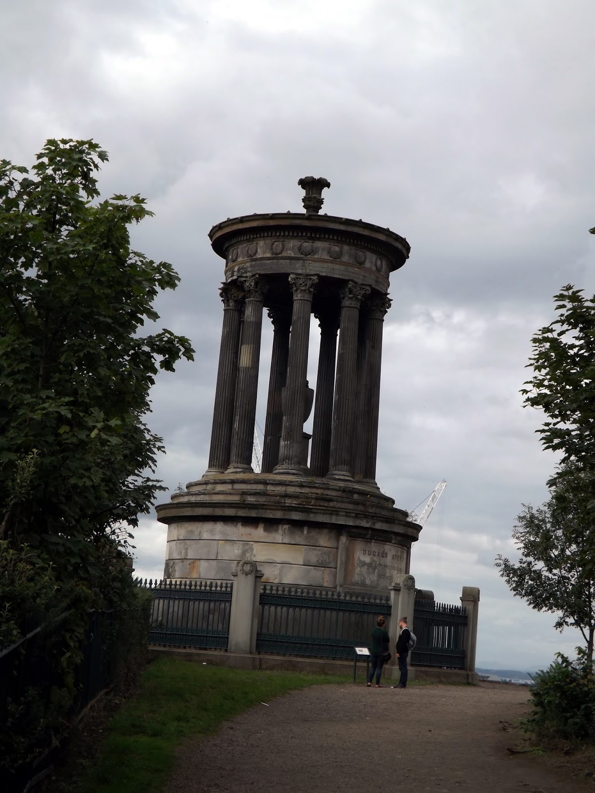 |
| The Dugald Stewart Monument is a memorial to the Scottish philosopher Dugald Stewart (1753–1828). It is situated on Calton Hill overlooking the city of Edinburgh and was designed by Scottish architect William Henry Playfair. It was completed in September 1831. |

 |
| Old Observatory House |


 |
| View back to Edinburgh Castle |
 |
| The View North |
 |
| Calton hill Trig Point |

 |
| The National monument and Nelsons Monumnet |
 |
| The Observatory |
The City Observatory is an astronomical observatory on Calton Hill in Edinburgh, Scotland. It is also known as the Calton Hill Observatory.
The site is enclosed by a boundary wall with a monument to John Playfair, president of the Edinburgh Astronomical Institution, in the southeast corner. The oldest part is the Gothic Tower in the southwest corner, facing Princes Street and Edinburgh Castle. It is also known as Observatory House, the Old Observatory, or after its designer James Craig House. The central building with the appearance of a Greek temple is the Playfair Building, named after the building's designer William Henry Playfair. This houses the 6-inch (15 cm) refractor in its dome and the 6.4-inch (16 cm) transit telescope in its eastern wing. The largest dome of the site is the City Dome in the northeast corner. During the early 20th century this contained a 22-inch (56 cm) refractor.


 |
| View to Easter Road Stadium. Hibernian Football Club |

 |
| National Monument |
The National Monument of Scotland, on Calton Hill in Edinburgh, is Scotland's national memorial to the Scottish soldiers and sailors who died fighting in the Napoleonic Wars. It was intended, according to the inscription, to be "A Memorial of the Past and Incentive to the Future Heroism of the Men of Scotland".
The monument dominates the top of Calton Hill, just to the east of Princes Street. It was designed during 1823-6 by Charles Robert Cockerell and William Henry Playfair and is modelled upon the Parthenon in Athens. Construction started in 1826 and, due to the lack of funds, was left unfinished in 1829. This circumstance gave rise to various nicknames such as "Scotland's Disgrace", "Edinburgh's Disgrace", "the Pride and Poverty of Scotland" and "Edinburgh's Folly".


We walk up Nelsons Monument after paying £10 for the two of us to climb up.
The Nelson Monument is a commemorative tower in honour of Vice Admiral Horatio Nelson, located in Edinburgh, Scotland. It is situated on top of Calton Hill, and provides a dramatic termination to the vista along Princes Street from the west. The monument was built between 1807 and 1815 to commemorate Nelson's victory over the French and Spanish fleets at the Battle of Trafalgar in 1805, and his own death at the same battle. In 1853 a time ball was added, as a time signal to shipping in Leith harbour. The monument was restored in 2009.
The Royal Navy's White Ensign and signal flags spelling out Nelson's famous message "England expects that every man will do his duty" are flown from the Monument on Trafalgar Day each year.

The monument was constructed at the highest point of Calton Hill, at 171 metres (561 ft) above sea-level,[3] replacing an earlier mast used to send signals to shipping in the Forth.

The monument is 32 metres (105 ft) high, and has 143 steps leading to a public viewing gallery.The castellated design reflects the castellated prison buildings which stood on the south side of Calton Hill in the early 19th century.


 |
| St Andrews House. St. Andrew's House (SAH), on the southern flank of Calton Hill, Edinburgh, is the headquarters building of the Scottish Government. The building stands on the site of the former Calton Jail. Today, the turreted Governor's House is all that remains of the former prison, next to the Old Calton Burial Ground and Political Martyrs' Monument. |


 |
| The Political Martyrs Monument, located in the Old Calton Burial Ground on Calton Hill, Edinburgh, commemorates five political reformists from the late 18th and early 19th centuries. It is a 90 ft (27 m) tall obelisk on a square-plan base plinth all constructed in ashlar sandstone blocks. As part of the Burial Ground it is Category A listed. |
 |
| Arthurs Seat Arthur's Seat is the main peak of the group of hills in Edinburgh, Scotland, which form most of Holyrood Park, described by Robert Louis Stevenson as "a hill for magnitude, a mountain in virtue of its bold design".[1] It is situated just to the east of the city centre, about 1 mile (1.6 km) to the east of Edinburgh Castle. The hill rises above the city to a height of 250.5 m (822 ft), provides excellent panoramic views of the city and beyond, is relatively easy to climb, and is popular for hillwalking. Though it can be climbed from almost any direction, the easiest and simplest ascent is from the east, where a grassy slope rises above Dunsapie Loch. At a spur of the hill, Salisbury Crags has historically been a rock climbing venue with routes of various degrees of difficulty, but due to hazards, rock climbing is now restricted to the South Quarry and a permit is required. |


 |
| Holyrood Palace |
The Palace of Holyroodhouse, commonly referred to as Holyrood Palace, is the official residence of the British monarch in Scotland, Queen Elizabeth II. Located at the bottom of the Royal Mile in Edinburgh, at the opposite end to Edinburgh Castle, Holyrood Palace has served as the principal residence of the Kings and Queens of Scots since the 16th century, and is a setting for state occasions and official entertaining.
Queen Elizabeth spends one week in residence at Holyrood Palace at the beginning of each summer, where she carries out a range of official engagements and ceremonies. The 16th century Historic Apartments of Mary, Queen of Scots and the State Apartments, used for official and state entertaining, are open to the public throughout the year, except when members of the Royal Family are in residence.

 |
| View down from the top of Nelsons Monument |
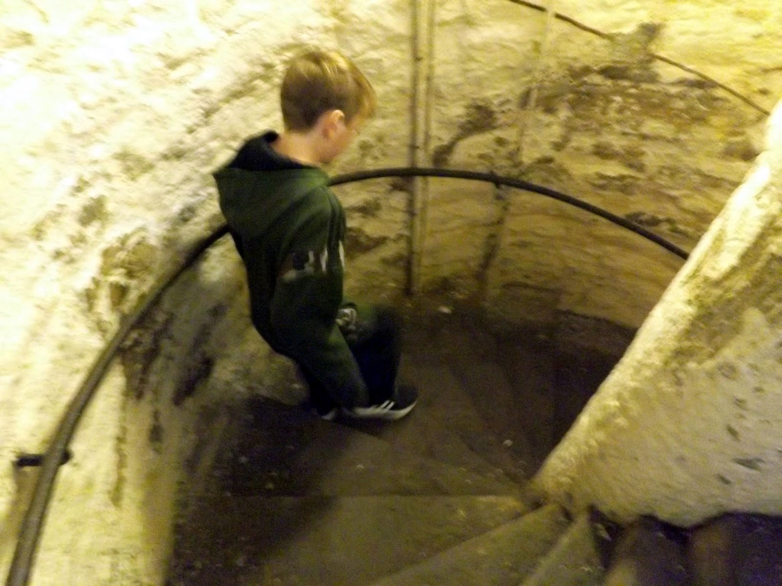
Going down the 143 steps.

We walk back down Princes Street and after a quick McDonalds back to the station for the 40 minute train ride back to Berwick Upon Tweed.
We arrive back in Berwick and walk to Megs Mount for views across the Tweed after navigating the local drunks by the river.

Megs Mount is a bastion where guns would have protected Berwick from attack from the river.


 |
| An old public toilet that now is a tea hut. |
 |
| Annie , Lady Jenningham Monument |


Berwick Bridge, also known as the Old Bridge, spans the River Tweed in Berwick-upon-Tweed, Northumberland, England. The current structure is a Grade I listed stone bridge built between 1611 and 1624.


The bridge is 1,164 feet (355 m) long and 17 feet (5.2 m) wide between the parapets, with an upwards slope towards the north-eastern end.[5] The spans are not even in length, and range between 24 feet (7.3 m) and 75 feet (23 m), the longest being the penultimate span at the north-eastern end.
It is built from sandstone quarried at Tweedmouth. The piers are founded on large oak piles from 873 trees, mainly taken from Chopwell Forest.


We walk along Quay Walls and through the wall into Sandgate.


We then walk up Hide Hill and onto Marygate.

 |
| Town Hall |
A Town Hall has stood on this site since at least the 16th century. Begun in 1750, this building stands majestically at the south end of Marygate. Until the 1830s, the Guild of Freemen governed civic affairs in Berwick from this building.
A guided tour of the Town Hall allows you to visit the jail and old town courtroom (reconstructed in the debtors’ jail). Secret gems include the 18th century graffiti in the ‘drunks’ cell’ and the ‘condemned’ cell!

We eventually made our way to Berwick Barracks and Main Guard.

Built in the early 18th century to the design of the distinguished architect Nicholas Hawksmoor, the Barracks was among the first in England to be purpose built. The 'By Beat of Drum' exhibition gives you an insight into the life of the British infantryman from the Civil War to the First World War.
A stone's throw away from the Scottish borders and located in a Georgian market town it also boasts a range of other temporary and permanent exhibitions to explore: The King's Own Scottish Borderers museum, the Berwick Gymnasium Art Gallery and the Berwick Museum and Art Gallery.


The barracks were built between 1717 and 1721 by Nicholas Hawksmoor for the Board of Ordnance to protect the town during the Jacobite risings.The work, which involved two parallel blocks of military accommodation, was supervised by Captain Thomas Phillips.An additional block was added between 1739 and 1741.After the Napoleonic Wars the barracks were abandoned but put back into use in the 1850s.
Following the Childers Reforms, the barracks became the depot of the King's Own Scottish Borderers, who arrived from Fulford Barracks in July 1881. The regiment moved out of the barracks in 1963 and they are now maintained by English Heritage.


We leave the Barracks and head out onto the Castles Ramparts.

Berwick Ramparts are a huge complex of 16th century town fortifications, founded by Queen Mary. Built inside the medieval town wall, which was then abandoned, they gave defence against the development of artillery and are unique in Britain. One and a half miles in length, the stone-faced ramparts are strengthened by immense arrowhead-shape bastions, which flanked huge wet ditches. The open ground of Magdalen Fields, is protected by the Bell Tower and an earthwork traverse line, which ends with the Great Bulwark Redoubt. Cowport is the only Elizabethan gateway remaining, its vaulted tunnel through the rampart was defended by a portcullis and still has a massive 18th century wooden gate. In the 17th century, the ramparts were given an earthwork parapet and all the bastions except King's, were heighten with earthwork cavaliers. Nearby is the Lord's Mount and Berwick Castle.


We are now back to the car to drive back to Budle Bay. A great day out!