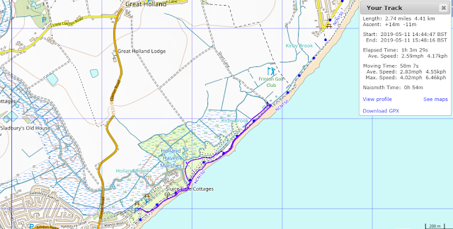
On Saturday the 11th of May 2019, My dog Ben and I drove up to Holland Haven at Holland on Sea for a walk.
We parked at the Holland Haven car park which isn't cheap at £2.50 for 2 hours, next time I'll park on the seafront and walk in I think.
I walk along the beach pass the brightly coloured beach huts.
 |
| Passing the Gunfleet Sailing Club |
The Gunfleet was the name of the large estuary fed by the Holland River or brook, which formerly ran into the sea between Frinton and Little Holland. The name is probably Anglo-Saxon in origin, as the second element ‘fleet’ is derived from the Old English word fleot meaning ‘stream’ or ‘creek’. A similar well known example is the River Fleet in London, a tributary of the River Thames which was fed by streams on Hampstead Heath and which used to have a tidal inlet and docks at its lower end. The origin of the first element of the name ‘Gun’ is currently unknown, but it possibly derived from an Anglo-Saxon personal name, so the meaning of the whole name could be something like ‘Gunna’s creek’. An alternative suggestion that has been made is that the first part of the name could be a corruption from the Count of Guisnes who possessed the manor of Little Holland in 1210.
However, the name was not recorded until 1320 when a vessel was shipwrecked on ‘Gunfletsond’, that is to say the Gunfleet Sands. It seems probable that a name originally applying to the estuary was appended to the sandbank that lay directly off the coast and opposite the estuary’s inlet. A map of 1584 in the British Library marks both the ‘Gonflet haven’ (the estuary) and the ‘ye gonflit’ (the sandbank). Other maps from that period, such as maps of Essex by Norden (1594) and Speed (1610) show the Gunfleet as a large, unreclaimed, estuary that was open to the sea at its southern end. The use of the name ‘haven’ would seem to imply the use of the estuary for trade, and the ‘Ganflete’ was also named as a port between Walton and St Osyth in Holinshed’s Chronicles (1586). The substantial marshlands along the estuary were also used by the inhabitants of surrounding parishes like Great and Little Holland as grazing for their sheep.
The reserve was the proposed landfall point for power cables to an offshore wind farm development on nearby Gunfleet Sands. A drilling rig was to be sited in the disused quarry but the Great Crested Newt came to the rescue and this didn't occur.
We approach the first hide ( a metal container) on the reserve.
The site itself allows viewing across a medium sized scrape along with a pond area, to the right from a large elevated 'container hide'. This can be found by walking approximately 500 yards northeast of the carpark, via the sluice. The scrape can provide good ‘all year round’ birding, although spring and autumn are best for scarce waders such as Temminck's Stint and Pectoral Sandpiper.
There is also a chance of outstanding local rarities, such as Lesser Yellowlegs and Marsh Sandpiper, both of which have been recorded over the years. Cattle Egret, Citrine Wagtail and Marbled Duck have been seen here and in the surrounding fields and grazing marsh in recent years. The rough grassland surrounding the scrape is attractive to owls and raptors.
From the hide I could see Little Egrets and shelduck, wished I'd bought my binoculars.
 |
| View to Great Holland |
 |
We pass the second hide and then rejoin the seawall.
Now it starts to pelt with rain, I have no waterproofs with me so the plan to walk over to Great Holland is abandoned.
We turn around and trudge on through the cold rain.
At reaching the golf course here, the only other undeveloped piece of land between Walton and Clacton on the course other than the reserve, we turn about and head back.
We pass one of the couple of Pill boxes here.Holland-on-Sea was known as Little Holland, a small village until the early 20th century.
During the Second World War Holland-on-Sea was fortified against German attack. There is a martello tower in nearby Clacton, which was also used during the Second World War. There is a Second World War pill box in Holland Haven Country Park. After the Second World War Holland-on-Sea went back to being a holiday town.
The rain stops and the welcome sun returns.
The tall Radar tower in the distance reappears,this is one of 12 that watch over the 26,000 ships passing through the Thames Estuary each year. It is unnamed and linked to the Port Control Centre in London by Microwave.
 |
| Wind farm out at sea |
As we walk back across the grass from the beach I come across a large rock with a metal plaque that read;
' AW PROJECT CLEANWATER
For cleaner beaches at Holland and Clacton
The Lady on the Bike grew and presented an Oak tree to Anglian Water in tunnelling achieved with 100% safety while building a 2.1 metre diatmeter sewer from Holland Haven to Anglefield Clacton in 1997 '
This commemorates a seven mile tunnel built by Anglian Water in world record time to take sewerage from Clacton to treatment works in Holland Haven. No idea what the lady on the bike and oak tree is all about though!!
We return back at the car at just under 3 miles, a short walk marred by bad weather.


