On Thursday the 9th June 2016 I set off to meet Dan at White Notley. We left one car here on Vicarage Road and made our way back to Great Waltham where we finished our last walk.
I parked up and we started our walk where we left off.
We joined the path again and walked through a field, thankfully it was all 'bull' and there wasn't a bull in the field at all!
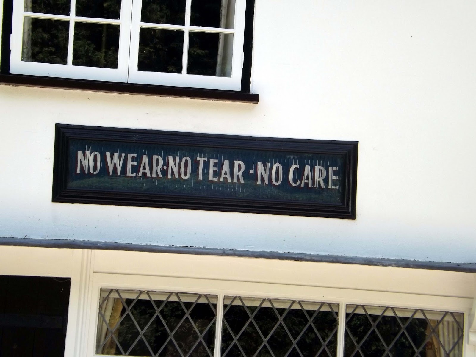
We head towards Langleys. The House retains the name of its 14th century owners. The Tufnel family acquired the estate in 1710 and created today's impressive Queen Anne residence. Great Waltham's older residents remember as children collecting acorns and beechnuts to sell to the keeper for the deer in Langley's deer park. There is a large pet cemetery at the end of the main driveway. The building beside the bridge over the River Chelmer housed a lace-making workshop run by the Squire's daughter at the turn of the century. From this seed a small lace-making industry grew, and the 'Lace Cottages' still stand on the edge of the village. In the gardens is the Great Horse Chestnut Tree, said to be nearly 300 years old and the largest in the British Isles.
Langley's is infamous for it's hauntings;
The manor has a story
attached which details the kidnapping of a young girl, perpetrated by an
apparition. However, little more is known.
|
|
Well so early on and we get lost already, instead of following the signs for the Saffron Trail we walk up towards Langley's as Dan was map reading and had made a mistake! Really wished I had checked as this would add another 2miles to our walk!!
So we walk past the building below and out onto Chelmsford Road, we were disorientated and tried to find ourselves on our phones but neither could get a GPS signal. I could kick myself I was relying purely on the guide and in situations like this an OS map would be invaluable! Its not only the mountains where a map and compass are a must at all times!
We walk along Chelmsford road trying to get a GPS signal, assuming we were heading in roughly the right direction.
We reach the end of the road where we turn left onto the B1008 and into Little Leighs.
I didn't talk much along this stretch, it always stresses me when I'm lost and I was eager to get back on the right path again.
We walk for what seems like miles before I see Chatham Hall Lane, which is on the guides map. This would lead us back to the Essex Way!
We pass the East Lodge, on the edge of The Langley Estate.
We now are back on The Essex Way!! Much relief , we push on.
We exit a field cross the busy Essex Regiment Way and back into a field on the other side.
We now reach the pretty village of Chatham Green. One you dream about living in, seems affordable too at a push, a 3 bed house is £325,000.
We walk on, crossing Whitbreads Farm towards The Leighs.
We pass an disused quarry which is now a fishery just outside of Little Leighs.
We exit onto Church Lane in Little Leighs. Here is St John The Evangelist Church. Its Nave is 12th century whilst the chancel later built 13th century.
Body-snatching was once common practice where stolen bodies were sold to medical students.In 1823 Samuel Clarke of Little Leighs was convicted and sentenced to be transported for 7 years, not for body-snatching but for the theft of the clothes in which the corpses were buried in.
We head off up the road turning right onto a road that crosses the River Ter.
We then turn right onto Whites Lane and into a chocolate box village. A pretty village indeed but we have no time to dwell, so we push on.
We pass under the busy A131 and over Deres Bridge.
We now follow the River Ter, and according to the map there is an Osier Bed nearby.
An Osier bed is where
historically willows were planted and coppiced to produce withies which
were used for basket making, fish-traps, and other purposes.
Wright's Timber-yard in Great Leighs is the worlds largest producer of raw cricket bat blades!
 |
| A rather pointless Sty |
We reach the ford on Paulk Hall Lane. I stop to wash my boots off before pushing on.
We follow the path across hole farm and more pasture fields.
 |
| A desirable property in a great location, in need of renovation. |
We enter a field of horses, as we got closer w could see the horses were knee deep in gloopy mud.
I said to Dan " You go on ahead, I'll hang back to see if its safe" jokingly. At this moment Dan goes knee deep in the gloop. I could hear the mud suck his leg into the hole and I couldn't help laugh as Dan struggles to get free. I meanwhile search out a safe passage across the field and arrive at the other side mud free, which is more than that can be said for Dan.
We exit out onto Cole Hill and pass a Spring that feeds out of a pipe. This feeds the River Ter.
We make a detour and head up to Lyons Hall and Lyons Hall Church.
The church stands on high ground above the River Ter about two
miles from the present village centre. The most striking feature is its
round tower, one of just six in Essex and said to be the best. Built
from flint, roman tiles and conglomerate two thousand years ago its
condition is a tribute to the care and skill of countless generations of
worshippers.
The base of this tower is Saxon in origin with a door from Norman
times inserted about 1100AD. The beautiful doorway has two layers of
stones, beautifully moulded by the masons with chevrons and chamfered
edges. The five Norman buttresses are for decoration, the massive walls
of the tower needing no support. The clock is Victorian and given by Mr
H. Tritton from Lyons Hall opposite..
The tower contains 5 bells, each inscribed
‘Miles Graye made me 1634’ and were cast in the churchyard.
The original building would have been thatched and wooden in structure and most was replaced in the 14
th century. There are sun-dials or mass clocks in the walls, a Priests door with original ancient iron work and a Leper window.
 |
| Lyons Hall |
Lyons Hall is a Grade II listed house in Great Leighs, Essex.
The house dates to the 15th century.
The house has been home to the Tritton banking family for many years, and Joseph Herbert Tritton died there in 1923.
After a quick look about the church, we head back the way we came and back onto the path crossing some fields heading towards Fuller Street.
As we approach Fuller Street we can see
The Square and Compasses PH. A lovely 17th century pub.
Dan checks out another telephone box, this one has been converted into a Essex Way information kiosk.
We stop off for a Adnams Lighthouse Ale before continuing on our way.
We walk on passing the Old Store. Here is a Soap Advertisement, that changes as you look at it from different angles!
We turn right onto more fields and we cross the River Ter once more.
We pass by Sandy Wood. This is an ancient woodland which existed in medieval times.Now we reach Terling. Another pretty village that time forgot.
We pass Terling Windmill. Now sail-less and converted into a private residence, Terling windmill is one of only two 'smock' mills in Essex. Commercial windmilling was tragically ended in 1950 when miller Herbert Bonner was crushed to death in its machinery after operating it safely for half a century. The mill was originally built at Cressing in 1770 and was moved to Terling in 1830 mounted on several horse mounted carts. Re-locating windmills was quite common and on such occasions it was usual to declare a village holiday. Now white, Terling windmill was painted black during World War One as camouflage against zeppelin bombers which could use it as a landmark enroute to london. The mill co-starred with comic Will hay in his 1937 film "Oh Mr Porter!" in which a man was twirled around on its rotating sails.
We reach Terlings Ford, which is deceptively deep, as several motorists have found out over the years. There's now a sign saying its unsuitable for motor vehicles.
I suggest to Dan that maybe he should try and wash some of the mud from himself in the ford!
We enter the other side of Terling cut off by the ford, and enter another field. Here I was distracted by my phone after receiving a text from work colleagues. Dan walked ahead and we missed a sign and ended up slightly off course again. So We missed out on Fairstead Church which we could see from the road we were now on.
 |
| Fairstead Church |
Some of the bricks from the church are from the Roman Villa that once stood nearby.
We turn up Troys Chase and past Troys Hall.
We exit out onto Church Hill in White Notley now. My feet are starting to ache and I'm glad its almost at an end.
The name is supposed to have been derived from the Old English (Anglo-Saxon) "
knut" and "
ley"
(meaning "nut pasture") and is mentioned in the Domesday Book (1086
A.D.) as Nutle[i]a. The hazel trees for which the Anglo-Saxon settlement
was named still proliferate around the village and in the hedgerows of
the surrounding fields. It is close to the location of the former
Knights Templar Preceptory of
Cressing Temple.
We take another path along whiteways and past mount pleasant, , where a small terrier decided to run and bark at our feet as we walked
along. Clearly it hadn't read the signs warning that all dogs must be
on a lead!
We cross the River Brain by a footbridge and turn left back towards White Notley and our car. I had hoped to visit Cressing Temple but will save this for our next walk as We're tired and time has ran away from us after our lost diversion at the beginning of the walk.
We cross the ford and the River Brain again, where I saw a lobe chub slip away into its flowing waters.
The pub here is currently closed for refurbishment, so check before walking if you intend to stop for refreshments.
Now back at the car after a 13 mile walk, we head back to Great Waltham to pick up my car. An enjoyable walk in the Essex countryside and the sun!