On Wednesday the 19th of September 2019 Dan and I set off to walk the second and final part of The Medway Valley Walk from East Farleigh to Rochester.
We parked up again in Station Hill in East Farleigh and walked back down to the river.
GPX File here ( Official Route)
GPX File here (Route we took due to path closures)
Viewranger file here.

We walked under the Medieval bridge that during the civil war General Fairfax and his men came over the bridge on their way to engage the Royalist forces in Maidstone.

 |
| The Medieval bridge at East Farleigh |
East Farleigh was already established at the time of the Doomday book and consisted of a church, 3 mills, six eel fisheries, 12 acres of pasture and wood for 115 hogs. Long before then a Roman nobleman had a villa here.
 |
| A lock at East Faleigh |

 |
| Some gorgeous houses in East Farleigh backing onto the Medway. |
 |
| Luckily we didn't need to use this gate! |

 |
| A pair of Mute swans |
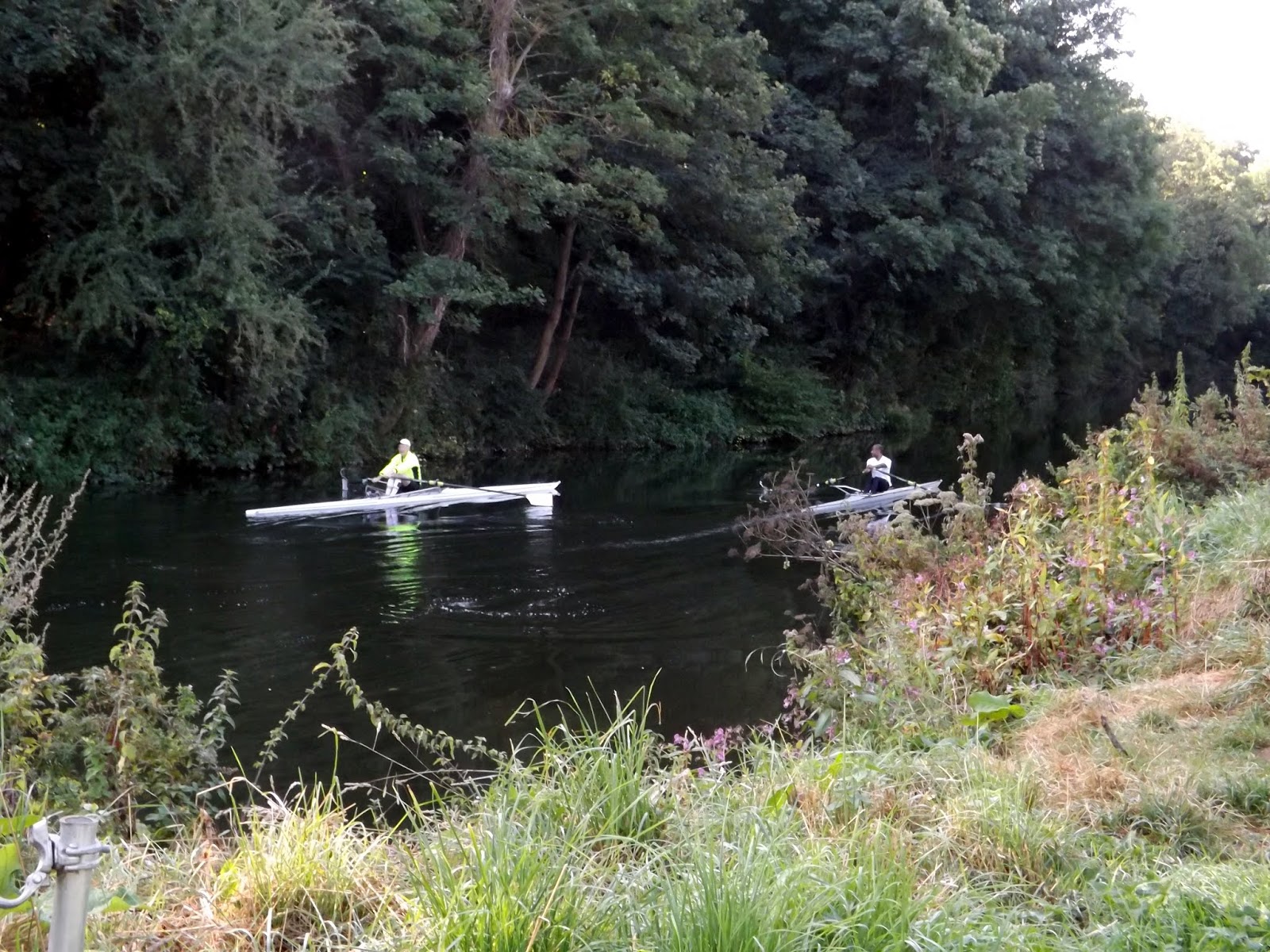
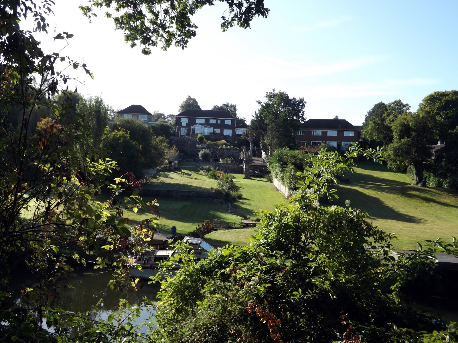
The river was busy today with plenty of rowers enjoying the river and the lovely weather.

We are now approaching Maidstone.
Neolithic finds have revealed the earliest occupation of Maidstone, and the Romans have left their mark in the road through the town and evidence of villas. The Normans set up a shire moot, and religious organisations established an abbey at Boxley, hospitals and a college for priests. Today's suburb of Penenden Heath was a place of execution in medieval times.

Maidstone played a key role during the Peasants' Revolt of 1381. The rebel priest John Ball had been imprisoned there and was freed by Kentish rebels under the command of Wat Tyler, who is reputed to have been a resident of the town.
Maidstone's charter as a town was granted in 1549; although briefly revoked, a new charter in 1551 created the town as a borough. The charter was ratified in 1619 under James I, and the coat of arms was designed, bearing a golden lion and a representation of the river (in heraldic terms: Or, a fess wavy Azure between three roundels Gules, on a chief Gules a leopard passant gardant Or). Recently to these arms were added the head of a white horse (representing Invicta, the motto of the county of Kent), a golden lion and an iguanodon. The iguanodon relates to the discovery in the 19th century of the fossilised remains of that dinosaur, now in the Natural History Museum in London. Maidstone has had the right to a town gaol since 1604.
During the English Civil War, the Battle of Maidstone took place in 1648, resulting in a victory for the Parliamentarians. Andrew Broughton, who was Mayor of Maidstone in 1649 (and also Clerk to the High Court of Justice) was responsible for declaring the death sentence on Charles I, and today a plaque in Maidstone Town Centre memorialises Broughton as 'Mayor and Regicide'.

We walk up to All Saints Church and College.

The College of All Saints was an ecclesiastical college in Maidstone, Kent, England, founded in 1395 by Archbishop Courtenay. It was part of the establishment of the nearby Archbishop's Palace, but was closed in 1546. The College church was the neighbouring Church of All Saints. Following its closure, the College estate was sold. The buildings and land passed through the ownership of three aristocratic families, being farmed until the late 19th century. A number of the College's buildings survive and all are listed buildings. Additionally, the whole site of the College is protected as a scheduled monument.

All Saints Church was founded by Archbishop of Canterbury William Courtenay in 1395 as part of a new College of All Saints, the church replaced an earlier one on the site dedicated to St Mary.[ Courtenay died in 1396 and the church and college were completed by his successor, Thomas Arundel, between 1396 and 1398.[ Richard II endowed the college with land and income from the Hospital of St Peter and St Paul in Maidstone and from the parishes of Linton, Farleigh, Sutton and Crundale. The college was also granted the advowsons for the parishes. To cover the cost of building the college, Courtenay obtained a bull to levy a charge of fourpence in the pound on all ecclesiastical revenue raised in his archbishopric.
When the college was closed in 1546 following the passing of the Chantries Act, its annual income was valued at £208 6s 2d (equivalent to £122,000 in 2018). The church and the college were separated. The church became the parish church for the whole of Maidstone and the college's estate was granted to George Brooke, Baron Cobham but was forfeited to the crown in 1603 when his grandson, Henry Brooke, the 11th Baron Cobham, was charged with high treason for his part in the Main Plot against James I. In the reign of Charles I the college became the property of Sir Edward Henden and later passed into the family of the Earls of Romney.

 |
| The Arch bishops Palace. |


Paper mills, stone quarrying, brewing and the cloth industry have all flourished here. The paper maker James Whatman and his son invented wove paper (Whatman paper) at Turkey Mill from 1740, an important development in the history of printing.

A permanent military presence was established in the town with the completion of cavalry barracks in 1798. Invicta Park Barracks is now home to the 36 Engineer Regiment.
Maidstone Prison is north of the town centre and was completed in 1819.


Maidstone listed in the Doomsday book as six mills, a church and two msalthouses. By the Middle ages it had grown as an agriculture and industrial centre with The Medway being the main means of transportation of goods to local outside markets.

Wyatt's Rebellion, a popular uprising in England in 1554, named after Thomas Wyatt, one of its leaders. The rebellion arose out of concern over Queen Mary I's determination to marry Philip of Spain, which was an unpopular policy with the English. Queen Mary's overthrow was implied in the rebellion, although not expressly stated as a goal.
Maidstone lost its charter and Wyatt lost his head. The charter was restored five yeras later by Elizabeth I and the town became a borough. This enabled them to have a voice in Parliament. Maidstone was able to elect two MPs and authorisation was given to hold a weekly market and fair four times a year.


Now as we leave Maidsrone behind we approach Allington and come to Allington Castle which can be seen from across the river.

Allington Castle is a Medieval 12th-century castle that lies about three miles north-west of Maidstone in Kent. It is fully furnished in character with its Medieval origins, with tapestries, antique furniture and Great Hall in which Henry VIII & Anne Boleyn dined with Sir Thomas Wyatt around 1530.
All that remains of the original castle is a section of wall and the kitchen fireplace built in 1174. The Castle was converted into a mansion house in 1491 when the Wyatt family acquired the property. It was severely damaged by fire in the late 16th century and was abandoned until 1905. The castle was then purchased and partly restored by Sir Martin Conway. Between 1951 and 1999 the castle was home to a convent of the Order of Carmelites.

Although the castle is a private residence, the Great Hall, barn and gardens can be hired as an exclusive wedding venue, corporate event venue and as a filming location.


We stop at The Malta Inn ,a Beefeater pub at Allingon Lock where we sat outside and had our lunch.

Here the river becomes Tidal, if it wasnt for the lock the tidal reach would stretch for another four miles.
This is the first and last lock on The Medway. Originally constructed in 1795 and enlarged in 1881. The present locks dates from 1939.
 The Allington Flood barrier is an electrically operated automatic sluices that control water levels upstream.
We cross over the lock by the bridge and across to the other side of the lock.


No we leave the river and follow a road that heads uphill.

We pass a church and a grand looking property but nothing is mentioned on the maps!

We follow the road past Blue Circle Concrete and take a footpath that will lead us to a bridge that crosses the M20 motorway.


After crossing the M20 we are out into open farmland , we follow the path along.


 |
| Church in Aylesford in the distance. |

We cross over the Railway tracks and follow the path alongside, where we pick an apple off a tree thats growing nearby.

We rejoin The Medway after a while and follow this into Aylesford.

Due to the village's location on its banks, the River Medway has been a key influence on its development. Aylesford takes its name from an Old English personal name, and literally denotes ‘Ægel’s ford’. Its first recorded use is from the tenth century, as Æglesforda.
It was also the place where one of the earliest bridges across the Medway was built, believed to be in the 14th century (although the wide central span seen today is later). Upstream from Rochester Bridge it became the next bridging point. The river was navigable as far as Maidstone until 1740, when barges of forty tons could reach as far as Tonbridge. As a result, wharves were built, one being at Aylesford. Corn, fodder and fruit, along with stone and timber, were the principal cargoes.
Due to increased road traffic in recent years, the ancient bridge has now been superseded by a modern structure nearby, but remains in use for pedestrians.


On the High Street, near the steps leading to the Church. A grey plaque in the centre of a wall gives details of the Aylesford Cage. It reads 'During the 19th Century, felons were impounded in a cage or lock-up prior to being taken before the magistrate at West Malling. This practise ceased with the introduction of police stations and the cage at Aylesford was demolished in 1870. In December 1975, remnants of the ironworks were discovered whilst strengthening this wall and this plaque marks the location of the find.


Further up we reach where the High Street meets Bull Lane, here on the left is Aylesford Priory. I stayed here for a weekend when I was a teenager on a youth leader course.
The Friars - Aylesford Priory - is an ancient religious house of the Order of Carmelites dating back to the 13th Century.

Aylesford Priory, or 'The Friars' to give it its traditional name, was founded in 1242 when the first Carmelites arrived from the Holy Land. They came under the patronage of Richard de Grey, a crusader, who gave them a small piece of land at his manor of Aylesford.


We stop for tea and cake at The Friary Tea room before continuing our walk.

We take the path and walk past the Sewage works, a lovely smell in the air.
Further up theres a sign footpath CLOSED. We decide to walk on but further up a digger driver told us we have to walk back a there is heavy machinery up ahead.
Disaster, we back track up along way back to Bull Lane and follow this into Eccles. All the footpaths in the area are closed!
Further up theres a sign footpath CLOSED. We decide to walk on but further up a digger driver told us we have to walk back a there is heavy machinery up ahead.
Disaster, we back track up along way back to Bull Lane and follow this into Eccles. All the footpaths in the area are closed!

Prior to 1850, the area now occupied by Eccles was mostly farms and arable land. Around that time, the renowned Victorian master builder Thomas Cubitt bought 2 farms near the river and opened a brickyard and cement works. The brick works was the most advanced in the world producing up to 30 million bricks a year. Situated on a gentle slope, the buildings were positioned along tram lines so that each stage of manufacture moved closer to the quay; with this arrangement production progressed by gravity rather haulage. At its peak, the works employed almost a thousand men and boys. The plant formally closed in 1941 and was later demolished.
As the brick works was established, a local farmer Thomas Abbot built a terrace of 22 cottages to house the workers, the settlement soon increased to 300. The area was known as ‘Bull Lane’ before it adopted the name of ‘Eccles’. The former name still appears on the Ordnance Survey map of 1897.
Although the village did not acquire the name ‘Eccles’ until some time in the second half of the 19th century, the name is not new. In her book “The Place Names of Kent”, Judith Glover traces it in its present form back to 1208 and suggests that it derived from the 10th century 'Aecclesse', meaning the 'meadow of the oak'. The Domesday Book records Eccles as ‘Aiglessa’. It has also been suggested that the name 'Eccles' comes from the Latin word 'ecclesia' meaning 'church', implying that a post-Roman Christian community existed in the area, although there is no evidence for this. Volume 4 of "The History and Topographical Survey of the County of Kent", published in 1798, reports that Eccles was a manor of the parish of Aylesford, "which was of some note in the time of the Conqueror, being then part of the possessions of Odo, bishop of Baieux, the king's half brother, under the general title of whose lands it is thus entered in the book of Domesday". The site of the manor of Eccles was lost to public knowledge by the 18th Century, but it was surmised to be somewhere at the eastern extremity of the parish, near Boxley hill.

We trudge along roads for miles, now really pee'd off. I had walked the Ayesford to Wouldham way before and had seen the Medway Stone commemorating the battle of the Medway but Dan hadn't !
After much walking we could see the Medway in the distance.
After much walking we could see the Medway in the distance.


We eventually rejoin the official path and climb up the steep path to The North Downs Way.

At the top of the hill we turn left and walk on, soon we could see the M2 crossing over The Medway. strange seeing it from here, Im usually always driving over instead.

The bridge cost 2.3 million to build and measures two-thirds of a mile long.


As we approach the M2 we can see the Borstal HM Prison and youth offender Institution up on the hill.

A Borstal was a type of youth detention centre in the United Kingdom and the Commonwealth. In India, it is known as a Borstal school.
Borstals were run by HM Prison Service and were intended to reform young people. The word is sometimes used loosely to apply to other kinds of youth institutions or reformatories, such as approved schools and youth detention centres. The court sentence was officially called "Borstal training". Borstals were originally for offenders under 21, but in the 1930s the maximum age was increased to 23. The Criminal Justice Act 1982 abolished the Borstal system in the UK, introducing youth custody centres instead.

We walk down to the M2 and pass a sign, I did chance my luck and walk over onto the property, I lived to tell.

Now after walking under the M2 we walk into Bortsal.

Borstal is a place in the unitary authority of Medway in South East England. Originally a village near Rochester, it has become absorbed by the expansion of Rochester. The youth prison at Borstal gave its name to the Borstal reform school system.

Its name came from Anglo-Saxon burg-steall "fort site" or "place of refuge", likely referring to the hill there. The hill is now the home to Fort Borstal. However, local resident Donald Maxwell argued that a 'borstal' was "a track up a chalk hill", claiming to have heard local farmers use the term in this way.
We walk down a load of small pats behind properties full of rubbish before we then enter Batys Marsh reserve.

Baty's Marsh is a 10.4-hectare (26-acre) Local Nature Reserve in Rochester in Kent. It is owned and managed by Medway Council.
This is one of the few remaining salt marshes in the Medway area, and it has a rich fauna, especially wading birds.

We are now following The Medway into Rochester. My feet are killing me. Ankle is hurting and pains on the top of my feet. Im now starting to hobble along. Not too far now I hope.

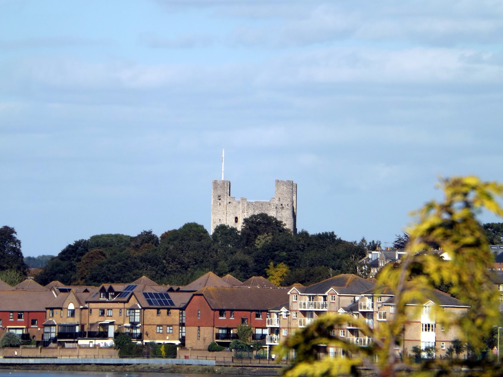
I can see Rochester Castle in the distance.
Strategically placed astride the London Road, guarding an important crossing of the River Medway, this imposing fortress has a complex history of destruction and rebuilding. Today it stands as a proud reminder of the history of Rochester, along with the cathedral and cobbled streets.
Its Norman tower-keep of Kentish ragstone was built about 1127 by William of Corbeil, Archbishop of Canterbury, with the encouragement of Henry I. Consisting of three floors above a basement, it still stands 113 feet high. Attached is a tall protruding forebuilding, with its own set of defences to pass through before the keep itself could be entered at first floor level.
In 1215, garrisoned by rebel barons, the castle endured an epic siege by King John. Having first undermined the outer wall, John used the fat of 40 pigs to fire a mine under the keep, bringing its southern corner crashing down. Even then the defenders held on, until they were eventually starved out after resisting for two months.
Rebuilt under Henry III and Edward I, the castle remained as a viable fortress until the sixteenth century.


The bridge we need to cross to get to Strood railway station comes into sight.


Rochester was for many years a favourite of Charles Dickens, who owned nearby Gads Hill Place, Higham, basing many of his novels on the area. The Diocese of Rochester, the second oldest in England, is centred on Rochester Cathedral and was responsible for the founding of a school, now The King's School in 604 AD, which is recognised as being the second oldest continuously running school in the world.

We finally reach the bridge and cross over.
Twin road bridges, one dating from 1856 and the other completed in 1970. A trust founded in the 14th century still pays for the upkeep.
Twin road bridges, one dating from 1856 and the other completed in 1970. A trust founded in the 14th century still pays for the upkeep.


After a long walk of 17 miles we are now at the Railway station and a £7 ticket sees me back to East Farliegh.

A great walk marred by The closure of paths. Now to drive home and rest my legs!