Viewranger File Here
On Monday the 19th April 2021 I drove to Manuden where I parked alongside roadside just up from the church.
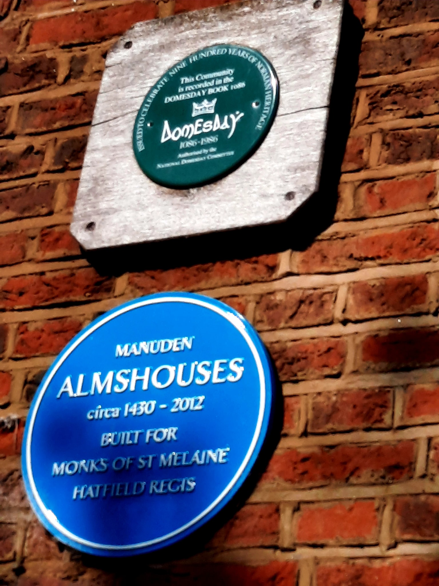
Manuden is mentioned in the Domesday Book of 1086 as one of the settlements within Clavering hundred.

Manuden is in a designated conservation area - unspoilt even by streetlights. The local council fiercely protects trees -particularly yews. Yew was the favoured wood of medieval archers and fletchers - hence the name of the village pub, "The Yew Tree Inn".

The Street, is lined with Grade II listed medieval houses, former shops and inns. There is also a wealth of vernacular medieval architecture (a malt loft which juts out over the street at an alarming angle, a thatched privy and an icehouse being a few examples). The splendid flint-coated church of St Mary the Virgin, Manuden dates back to 1143 but, although it retains some Norman features, it was largely rebuilt between 1863-76. Several fine country houses add to the charm of the village, which is surrounded by gently rising fields.


In A.D. 1143 a Norman knight, Richard de Camvill and his wife Alicia, gave "the Church of MANEGUEDANA to God and Saint Melaine and his monks at the Church of Hatfield Regis for ever".
This Benedictine priory at Hatfield Broad Oak dedicated to a 6th century French saint had been founded in A.D. 1135 by Auhrey de Vere, whose grandfather had been Lord of the Manor of Manuden. Although there is no trace of a church prior to the present structure it is reasonable to assume there was one as Manuden had well-established roots in Saxon times with several of its manors recorded in the Domesday Survey of A.D. 1186.
The present building is a much restored medieval church, which suffered partial rebuilding of its chancel in 1746 and drastic major restoration of the entire building, except the north transept, in 1863-67. Fortunately, some interesting work did survive, notably the magnificent chancel screen, the north transept and the nave roof.

The church originally consisted of a nave and chancel, to which was added a south aisle or chapel followed by a small private manorial chapel on the north side. The roof of the nave and transept are probably 15th century work and noteworthy for their king-post construction with the roof ceiled below the rafters. The tie beams are not visible, being enclosed in ornamental casing.

First recorded as a Saxon settlement in the Domesday Book of 1086, Manuden in the 21st Century has a strong sense of community spirit and a fierce pride in its history. So much so that, in the summer of 2000, all roads to Manuden were sealed off while villagers (in costume) enacted a pageant of scenes from the history of the village, researched by the formidable History Society. Scenes included the Domesday inspection, a murder and hanging, a visit by Queen Elizabeth I, a World War II evacuation and a Silver Jubilee Party.

After a little walk about looking at the Church and The Street I walk on back down pass The Yew Tree Pub and cross over The River Stort.

After crossing the bridge and turning left I follow the road for a very short distance before turning right up a bridle path and uphill.

I follow the Harcamlow Way over several fields.

I walk out onto a road that passes Bollington Hall Farm and head on up the quiet road.


I reach Wades Hall and continue onwards. To my right I see a Red Kite soaring up high.

The path now leads me pass Broom Wood, I see skylarks rising from the fields next to me.


Further along the path I turn right onto another footpath at the junction you see below.

Now the path is clearly marked on the map, but it disappears as I am to enter Broom Wood, not sure what happened here, but I make my way through the best I can.
This wood will look amazing next month when the blanket of bluebells will be in bloom!

I exit the wood and out onto the B1383 and up to The Chequers at Ugley. (Or as the sign says The Beautiful Ugley Chequers). Anyway didn't look like it was open.

So I turn left at the road that the pub sits on the corner of.

I follow the road through Ugley, which is actually really beautiful.

Ugley was first recorded in 1041 as "Uggele". It appears in the Domesday Book as "Ugghelea". The name probably means "woodland clearing of a man named Ugga.

I walk further up the road to St Peters Church at Ugley.


A large Tudor brick tower is attached to the west end of the nave which is dated 13th century. The rest of the church is flint from a rebuild in 1866. Some masonry was sourced from the ruins of nearby Bolington church.

I walk through the graveyard to the rear, where someone with some instruments was bust marking and plotting each grave.

I walk on down through Ugley Hall Farm, where the fields were full of lambs.


I eventually walk out of the fields and into Ugley Green.

The village contains two Grade II listed 19th-century houses, and a post-medieval house.


I walk down the road before taking a footpath to my left and follow this across more fields.


I was so busy watching rabbits bolting back into their burrows, that I missed my next path and instead join a busy B1383 road at the bottom.

Anyway I walk a short stretch before walking back up Alsa Street and taking a path on my right and I'm back on the route.

I am now walking into Stansted Mountfitchet.

First pub I vame to The Dog and Duck, alas sadly not open yet! I walk on.

Stansted was a Saxon settlement (the name means 'stony place' in Anglo-Saxon) that predates the Norman conquest. In the 1086 Domesday Book, Stansted was in the ancient hundred of Uttlesford. It was one of many villages and manors controlled by the powerful Robert Gernon de Montfichet (from Montfiquet in Calvados, Normandy), so began to be referred to as Stansted Mountfitchet to differentiate it from similarly named places. A small remnant of his castle remains, around which a reconstruction of an early Norman castle has been built. Believed to have been fortified originally in the Iron Age, and subsequently by the Romans and Vikings, construction of the Norman castle began in 1066. Lord Mountfitchet is also considered the 11th century builder of Montfichet's Tower in London.

Another bar, closed. I will find an open pub!

During the Second World War, the US Air Force constructed an airfield near the village. After the war ended, it was subsequently taken over by the government and developed as a commercial airport now known as Stansted Airport.

Yay! The Kings Arms is open! A pint of Laines Mangolicious and some chips ordered.

Great Glass, after a chat with the lovely Landlady she let me keep it!
I leave the pub, not realising a short walk away was the Castle I wanted to visit. But I walked the wrong direction from it and didn't want to backtrack so I will visit it another time.

After walking uphill a bit I reach the windmill.
Stansted Mountfitchet Windmill was built in 1787 for Joseph Lindsell. Lindsell sold the mill in 1807 to Henry Chaplin, who mortgaged the mill to Robert Sworder in April 1808. Chaplin died in 1844 and the mill was offered for sale by auction on 22 December 1846 without a buyer being found.

In 1847, it was reported that one pair of sails required replacement. The old Common sails were replaced with a pair of Spring sails at a cost of £29 4s 0d by Thomas Seabrook, millwright of Furneaux Pelham, Hertfordshire. In March 1848, it was reported that one of the remaining Common sails had blown down, and the remaining sail was not fit for further work. A pair of “new Patent sails” was fitted at a cost of £12 5s 0d, with a new sail back costing a further £5 13s 4d. In November 1848 the mill was again working on two sails, and another pair of Patent sails were fitted at a cost of £23. Hicks demanded a reduction in rent from £60 to £45 per annum at midsummer 1850, which he was successful in obtaining. In 1850, Hicks wrote “The mill has ground scarcely anything for the last month for want of wind there is great loss of time often. A windmill is not worth much with the present trade.”
Hicks left the mill in 1853, and recommended William Randall Dixon to be the next tenant. Dixon took the mill on a seven-year lease at £45 in May that year. A bake office was built in February 1854 at Dixon's request and the rent was increased to £55. An oak stock was reported as cracked at about this time, and the mill was again reduced to two sails in September 1854 as a stock was defective. Dixon left the mill in 1856 and Edward Hicks again took the tenancy of the mill.
In 1860 Hicks asked for the mill to be modernised and asked the owner to install a steam engine to assist the sails. That proposal was rejected, but a new windshaft was required and a fantail was asked for in return for an increase in rent. The cap frame was also repaired, with a new weatherbeam fitted. A new cast iron windshaft was fitted by Seabrook at a cost of £25. Seabrook fitted a new fantail in that year at a cost of a further £25. Hicks left the mill in June 1861, and a local man by the name of Ervin took the mill at a reduced rent of £40. In 1862, millwright Fyson of Soham remodelled the machinery, converting the mill from an underdrift mill to an overdrift mill at a cost of £58 13s 7d. The stage and round house were removed at this time. John Buck took the mill in 1863 at a rent of £20, and reported that various work done by Fyson was faulty. Rectification was carried out by Seabrook. The mill was sold to William White in January 1865 for £1,150.

By 1870, the mill had four double Patent sails which were over 7 feet (2.1 m) wide. The mill last worked commercially in 1910 to crush oats. In 1930, the tower had to be strengthened with three iron bands and in 1934 the second Lord Blyth had the mill repaired and presented it to the parish. The mill served as a Scout hut from the 1940s to 1963. It was scheduled as an Ancient Monument in 1952. The mill was opened to the public for the first time in 1964, with restoration work being done in 1966. In 1984–5, the mill was repaired by Millwrights International of Mapledurham, Berkshire at a cost of £14,000. The work enabled both the cap and sails to turn. In 2003, the mill was struck by lightning during an open day. In 2005, it was reported that repairs costing £70,000 were needed. An appeal to local residents for support in raising money towards the repair of the mill was generally ignored, despite leafletting every house in Stansted Mountfitchet.
I walk down Mill Hill cross the B1838 and take a path just past Blythwood gardens into fields beyond.

After much walking around the fields in the hot sunshine I walk out onto a lane before taking another path across Hole Farm.


After more field walking, I eventually walk back out onto Carters Hill, that I drove up this morning to Manuden.
I walk down the road back towards the car.

Once a farming community with a mill and two maltings, the village still boasts two working farms dedicated to a mixture of arable, dairy and sheep farming. Leatherwork was made in the village from 1430 to 1900's, as evidenced by the tanner shown at work on the village sign.


After a 10 mile walk, Im back at the car for the drive home!
