Viewranger File Here
On Bank Holiday Monday Dan and I drove to the Devils Kneading Trough in Kent. We parked in the free carpark on Coldharbour Lane (TN25 5HE).
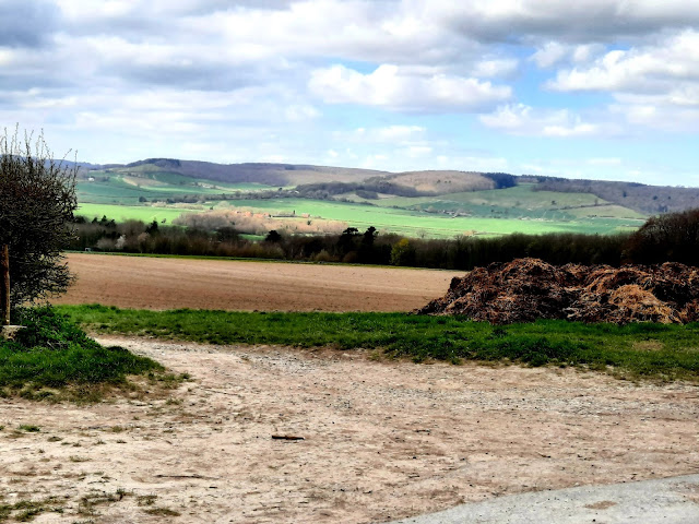
Leaving the car park we cross the road onto a path opposite with immediate views of the Devils Kneading Trough on the Wye Downs.

Known as the Devil’s Kneading Trough after its bowl-shaped appearance, this dramatic viewpoint sits at the heart of the Kent Downs AONB and is often described as Kent’s top beauty spot. Stunning views are a key feature of the AONB and from here you can see out over the flat Kentish Weald to Romney Marsh and as far as the English Channel.

It was formed after the last ice age, when torrents of meltwater cascaded down the slopes, eroding the chalk and forming steep-sided valleys known as coombes.

According to legend, anyone who walks around the Devil's Kneading Trough in Wye seven times before drinking water from the natural spring will see the devil in front of them.
Well I have no intention of walking this seven times, it is one steep hill!


So we walk down into the steep decline, you can skip this walk down and up if you like and just walk across the top.


It was one hell of a climb up, my heartbeat reached 188 bpm!

But boy what great views, I could see Dungeness Power Station and the wind farm beyond out at sea!

We walk on, uphill a bit more.


Crossing Coldharbour Lane we walk onto a footpath opposite.
We follow the track to Coombe Manor where we turn right just before uphill on a path to reach Hurst Wood.

It has now started to Sleet and snow. Typical British weather, yesterday I was in the garden in a T-Shirt!


The path continues into Towns Wood.

The woods were awash with Wood Anemones coming into bloom and my first bluebell this Spring!


We leave the wood and come across St Mary The Blessed Virgin at Crundale.

The church is of Norman origin, as can be seen from the surviving window in the north wall of the nave. The semi-circular arches of the two-bay arcade are also late Norman. In the eighteenth century the fine reredos with a scrolly pediment and the altar rails were installed. Also in the chancel is a nice single sedile under a carved canopy. The stonework of the east window is entirely a nineteenth-century creation. The rood loft stairway survives.


We leave the church, stop on the bench for some lunch. My GPS was having a fit and I was having trouble locating which way to g next. We walked across the path opposite, but backtracked walked down the road before taking a path on our left. Looking back either would have been Okay.

After following the path across a road and uphill we turn left onto a path that leads us into Warren Wood.

 |
| A sign of Spring, my first lambs sighted this year. |
 |


We continue out of the wood across Marriage Hill.

We walk into Beech wood and follow The Stour valley Walk.

The woods and bank below were filled with Wild garlic and you could smell its pungent fragrance in the air.


We pass a communications tower cross the road into Long Plantation.


We now follow a path to join a path that leads us into the village of Wye.

We reach St Gregory and St Martin Church.

There was a church here in the Saxon period, dedicated to St Gregory. That church was noted in the Domesday Book when Wye was a royal manor. Around 1200 the manor was granted to Battle Abbey, and a second dedication added to St Martin. Then in the middle of the 15th century, the Norman building was completely overhauled by John Kempe, Archbishop of Canterbury and a native of Wye.

Kempe's long career in the church led to him being in turn Bishop of Rochester, Chichester, and London. For 26 years he was Archbishop of York, until he was made a Cardinal and finally, Archbishop of Canterbury. He is buried in Canterbury Cathedral. The Kempe arms of three wheatsheaves can be seen in several locations around the church.

Kempe established a college of priests here to serve the church. After the Reformation, the college served as a grammar school and later became an agricultural college associated with London University. In 1572 the tower was struck by lightning, a fact which probably led to its ultimate collapse in 1686. The collapse of the tower destroyed the east end of the church, including the chancel and both aisles.


We leave the Church and walk up The High Street.

The village's name comes from the Old English "Wēoh" meaning "idol" or "shrine". The place may have used for worship by the pre-Christian Angles.

Wye became an important ancient communications centre because of the ford across the River Great Stour connecting the parts of the ancient trackway across the North Downs at this point. The Romans constructed their road between Canterbury and Hastings using the gap through the North Downs; remains of a Roman camp and villa have been found. By medieval times the town was a market and meeting place of the hundred court.
 |
| Wye College. |
The College of St Gregory and St Martin at Wye, more commonly known as Wye College, was an educational institution in the small village of Wye, Kent, England, 60 miles (100 km) east of London in the North Downs area.
Founded in 1447 by John Kempe, the Archbishop of York, as a college for the training of priests, in 1894, the school moved to new premises, and the South Eastern Agricultural College was established in the buildings with Alfred Daniel Hall as principal. In 1898, Wye became a School of Agriculture within the University of London. Until 2005, Wye College was a well-known study and research centre in the fields of rural business and management, biological sciences, and the environment and agriculture. The college was officially closed by its then owner, Imperial College London, in September 2009.
Today, buildings that formerly housed Wye College have been repurposed as the Mind Campus in Withersdane Hall,a substance abuse rehabilitation clinic, and Wye School, a school for children of year seven and up. The main campus and several other buildings have been owned by Telareal Trillium since 2015 who are developing a masterplan involving some new housing.


We walk up Scotton Street, taking a path that re-joins us on the path we took into Wye. We continue on crossing a road, where we sat on a bench for a drink before we took the path up the steep hill towards the Chalk Crown in the hillside.
 |
| Dominating the hill side of Wye is this spectacular white crown standing at approximately 180 feet tall, it truly is a sight to behold! |
The Wye Crown was first cut in 1902 by students from Wye Agricultural College working under the guidance of the Vice Principal T.J. Young.
Young copied a drawing of a crown from a florin (a coin worth two shillings, or 10p in modern money) and stuck it on his theodolite. He then got students carrying flags to climb the hill and peered through his theodolite so that he could direct them to place the flags so that they marked out the shape of the crown. Once the flags were in place, the students turned out en-mass and completed the cutting of the figure in just four days.
 |
| Looking back from where we came and the sun made a brief appearance. |
The figure was cut to celebrate the coronation of King Edward VII. On the night of the coronation the crown was illuminated by 1500 fairy lamps, a celebration that was repeated in 1935 for the silver jubilee of Edward’s son King George V.
During World War II the Wye Crown was covered up by having heaps of brushwood piled over it. The move was prompted by the fear that German bomber pilots would use the hill figure as an aid to navigation: it would certainly stand out clearly when seen from the air on moonlit nights.


After the steep climb, the last of the day, we reach the summit and are rewarded with amazing views.


After a rest we continue on across a path with views across to Ashford and the coast before we eventually arrive back at The Devils Kneading Trough again.

Back at the car after a 9.6 mile walk. What a great walk too!
