GPX File Here (GPS unit didn't record so a plotted route).
OutdoorActive file Here.
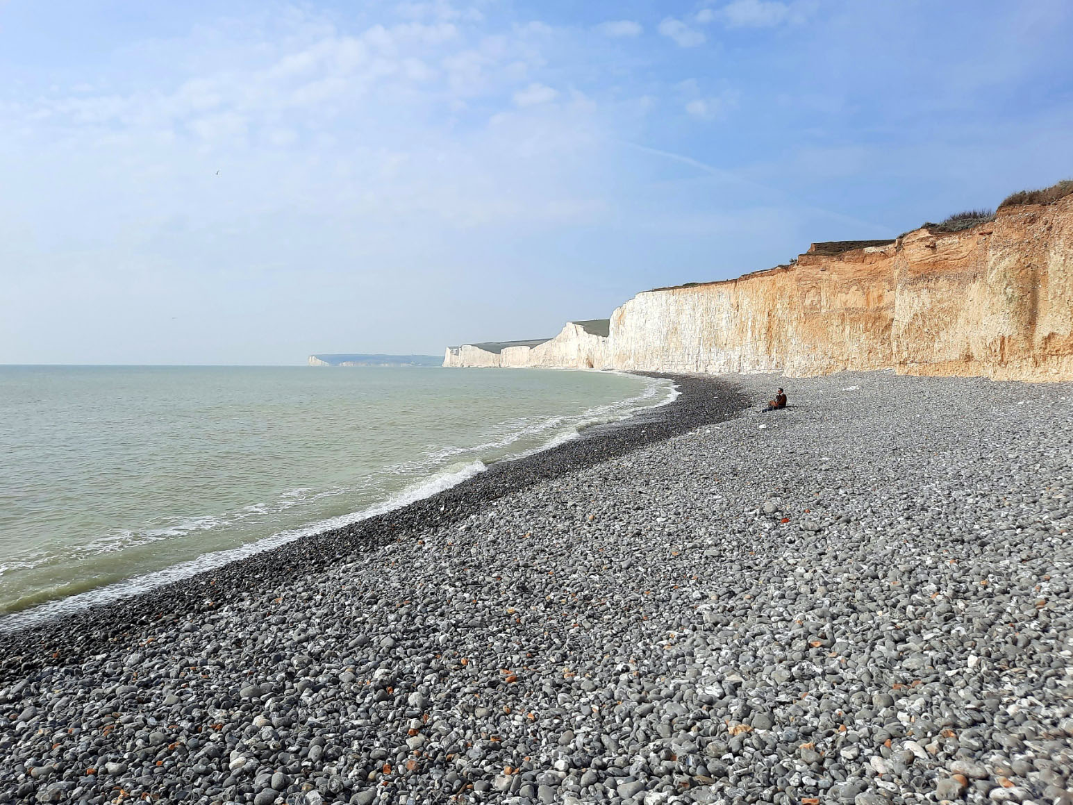
On Monday the 21st Match 2022 Mike and I drove to Seaford in East Sussex and parked on the seafront where there is free parking for 12 hours. We left the car wand walked off straight into a big climb up Seaford Head.

The first part of the footpath is on the Vanguard way, a footpath that runs from Croydon to Newhaven. The sign is easy to spot and goes up the headland. The view from the headland is spectacular and the path is adjacent to a golf course on the climb up.


Seaford Head


 |
| View down to Seaford. |

After quite a hard climb up, we are happy to walking up on top with no more climbing for now.


We head down past the Coastguard cottages towards the Cuckmere River, where we were escorted away from the path and onto another as a film crew were shooting a advert for TV.

Only one of the 3 coastguard cottages at Cuckmere Haven are still in use and is used as a holiday cottage.


We followed the path down to Cuckmere Haven where we had to walk inland to Exceat as we can't reach the Seven Sisters as the Cuckmere River blocks our way. It looked just about crossable apart from a small stretch that was too deep. Wish we'd just taken our boots off and paddled across rather than divert up to Exceat.

We follow the river up to Exceat where we pass The Cuckmere Inn.
It was 11am and the pub wasn't open till 12! Oh well never mind, we'll come again!

We cross the Exceat Bridge over the Cuckmere River and take a path that leads us back down the other side of the river.

Exceat (pronounced ex-seat) was an ancient village. The A259 goes by it just east of the River Cuckmere. The name may have come from the Old English for "the place of the Aese", early kings of Kent. After the Norman conquest, the village was given to Robert, Count of Mortain, half brother of William the Conqueror. Both Exceat and the land were given later to Grestein Priory in Wilmington.
Until the 14th century, Exceat was an important village with its own church. The village suffered French raids; it suffered many fatalities during the Black Death, as was effectively abandoned by the 15th century.

A way up the river we take a path across the water and take a path that will climb up to Haven Brow.


The view from the top is superb, back over Cuckmere Haven and to Seaford head in the West and views towards Beachy Head in the East.

We stop so Mike could try and have a cider on top of each Sister summit.

The Seven Sisters is the name for the undulating cliffs between Cuckmere Haven and Birling Gap. They are thought to have been formed by glacier melt water at the end of the last Ice Age: the melt water carved steep sided valleys, which were then truncated by sea erosion into the cliffs we see today.

There is a short descent down Haven Brow before the path again climbs on to Short Brow, the second of the Seven Sisters.

Down and up to Rough Brow before we reach Brass point.

We walk on as the Seven Sisters roll onwards like a rollercoaster.

We reach the Sarsen Stone seat on Flagstaff point where we stop for a drink and a bite to eat.

Sarsen stones are particular to the south coast of England. Around 40 to 60 million years ago, sediment formed by sand and silt became covered in groundwater which was rich in silica. Over time, the intensity of the silica increased, until the water could no longer hold it as part of a liquid solution. The silica solidified and filled the gaps between the sand, acting as glue to form a two metre thick band of rock across southern England. During the last 3 million years, and particularly during the last ice age, freeze-thaw cycles and water erosion broke this layer of sarsen up into boulders, leaving millions of them scattered across the landscape. Some have been put to good use, like Stonehenge for example.


After Flagstaff Brow there is one more climb up Bailey's Hill before you arrive at the hamlet of Birling Gap, where the is a pub and small hotel providing welcome refreshment. The beach here has some sand at low tide and has a Seaside Award. The Hotel, toilets and car park are now owned by the National Trust. Sadly, the coastal erosion here means that the row of cottages is slowly disappearing into the sea.


Its plaque states that Michel Dene was bequeathed to the National Trust by W A R Robertson, in memory of two of his brothers who were killed in the First World War.
 |
| Looking back from where we came. |

We descend down into Birling Gap.
Here we get a drink from the café and take the steps down to the beach.
I have a bite to eat before deciding I will brave a swim in the sea.

It's freezing, I can feel my feet going numb in the cold seawater. The tide is strong too pulling me backwards and then pushing me forwards again. But I hadn't gone out too far and could still stand so I felt safe enough.

A few minutes in was plenty as it was so cold but great to be back out in the water again.

 |
| A National Trust Kentish Red Ale from Westerham Brewery bought at the Café. |
We walk back up the steps and as we walk through the car park I see a 1933 Austin 10 ! What alovely car!


After Birling Gap, the path climbs the last of the Seven Sisters, Went Hill. From the top of Went Hill there are excellent views back towards Seaford and the Seven Sisters.

We head on up to the Belle Tout Lighthouse.

Belle Tout is a former lighthouse that first entered service in 1828, over 130 years after the need for one was first suggested. It had 30 oil lamps, requiring two gallons of oil per hour. A problem with the lighthouse’s location soon became apparent, however – when the weather was bad, the cliff top tended to be shrouded in mist, so the light could not be seen. The cliff also blocked the view of the light from ships sailing too close to the shore.
As a result, a new lighthouse was built – the one that still stands at the base of Beachy Head to this day. It opened in 1902, and Belle Tout went out of commission. It was a tea room for a while, accidentally damaged by Canadian artillery during World War II, and later restored by the local council.
By the 1990s Belle Tout was a private house and in danger of falling into the sea due to cliff erosion, and so in March 1999 in a feat of engineering that captured national media attention, it was moved back 17 metres away from the cliff using hydraulic jacks. It was then bought by a preservation trust and in March 2010 started a new life as a luxury bed and breakfast, with the lantern room turned into a lounge with 360 degree views.

As we walk away from Belle Tout Lighthouse another comes into view. This one is at Beachy Head.
This is a renowned suicide spot and you can see why that's one hell of a drop!
In 2010, it was the third most common suicide spot in the world, after the Golden Gate Bridge in San Francisco and the Aokigahara Woods in Japan.

The name Beachy Head appears as 'Beauchef' in 1274, becoming 'Beaucheif' by 1317, and it has nothing to do with the word "beach". Instead, it is a corruption of the original French words meaning "beautiful headland" (beau chef). It was being consistently called Beachy Head by 1724.
In 1929, Eastbourne bought 4,000 acres (1,600 hectares) of land surrounding Beachy Head to save it from development at a cost of about £100,000 (equivalent to £6,215,363 in 2020). This land became known as the Eastbourne Downland Estate.
The prominence of Beachy Head has made it a landmark for sailors in the English Channel. It is noted as such in the sea shanty Spanish Ladies:
The first land we sighted was called the Dodman,
Next Rame Head off Plymouth, off Portsmouth the Wight;
We sailed by Beachy, by Fairlight and Dover,
And then we bore up for the South Foreland light.

Human remains discovered in the 1950s were subjected to forensic reconstruction, carbon dating, and radioisotype analysis, and it was concluded that they were those of a Roman woman of Sub-Saharan African origin who grew up in the Eastbourne area in about 200–250 CE. She became known as Beachy Head Lady. However, in 2021, DNA testing indicated she was of "southern European lineage, most likely from Cyprus".


The headland has been considered a danger to shipping. In 1831, construction began on the Belle Tout Lighthouse on the next headland west from Beachy Head. Because mist and low clouds could hide the light of Belle Tout, it was decommissioned in 1902, after the Beachy Head Lighthouse had been built in the sea below Beachy Head as a replacement.


We walk on and find a welcome seat surrounded by plaques just before Cow Gap. Another cider before we push on.


We reach RAF Bomber Command Memorial further on along the path.


A proud memorial stood on Beachy Head for all those who lost there lives fighting under RAF Bomber Command.
This project, commissioned by a 90 year old man Joe Williams who is a very proud ex-bomber command rear gunner during World War II.
Joe’s vision was to have a memorial sited at the very spot where the last siting of UK land was seen when flying out to sea during the war, and for some, never returning, this being Beachy Head.
In order to achieve this, the memorial which was to be sited on protected land, which could not be walked on, meant the only way to get the monument to its chosen destination was by air, and the RAF Chinook crew took to assisting in the task.

At last the end comes into sight, but Eastbourne is still a very long way off yet.
 |
| Eastbourne in the distance. |


After much much walking we finally descend down into Eastbourne, and it felt strange to be walking on the flat and on tarmac.
 |
| All Saint Old Chapel |
All Saints The Old Chapel, a truly unique event venue, is situated in the picturesque seaside town of Eastbourne. Designed by Henry Woodyer, All Saints was built between 1867 and 1869 with land donated by the 7th Duke of Devonshire. The Grade II listed Gothic chapel was added in 1874. The chapel is the best example of Victorian Gothic in the region with some calling it Eastbourne's very own St Pancras station. All Saints may be themed and adapted to suit your vision, however incredible. Whether it be a wedding, private party, charitable event, dinner, drinks reception or a dance.

We walk on along the seafront passing the Bandstand and on towards the pier.

Though Eastbourne is a relatively new town, there is evidence of human occupation in the area from the Stone Age. The town grew as a fashionable tourist resort largely thanks to prominent landowner, William Cavendish, later to become the Duke of Devonshire. Cavendish appointed architect Henry Currey to design a street plan for the town, but not before sending him to Europe to draw inspiration. The resulting mix of architecture is typically Victorian and remains a key feature of Eastbourne.


We reach the pier where we take a short break on the beach before walking onto Memorial Roundabout where we catch the 12x bus on Cornfield Road back to Seaford Library. A relief to be sitting down at last!

Back at Seaford we walk from the Library bus stop and after getting the car we drive to Trawlers Fish Restaurant where we had Cod and chips. Lovely crisp batter and a nice restaurant. a 8.5/10!

We then drive home. A great walk at just under 13 miles with +889m(2916ft) of ascent and -891m(2923ft)of descent.
