The Medway Valley walk is a linear route follows just over 28 miles (45.2km) along the banks of the River Medway – a river which has shaped the lives of local people for centuries, providing power and water to fuel local industries and a key transport route through the county.
All walkers are bound to welcome the diversity of landscapes to be enjoyed along the river. These range from the bustling market towns of Tonbridge and Rochester through to picturesque villages, the fertile countryside supporting orchards and hop gardens and an Area of Outstanding Natural Beauty.
So I left home and after just under an hours drive, I park up for free on Station Hill in East Farleigh. It seems I had just missed the train and the next was 50 odd minutes, so I decided to have a stroll around while I waited.
GPX File here
Viewranger File Here

The population of the village expanded from 642 people in 1801 to 1,668 in 1881. The population growth occurred in parallel with an increase in hop production, which the tithe map of 1841 show covering a quarter of all land in the parish, 40 years before peak production was reached. Hops are no longer grown in the parish. The last oast house in the village ceased working in 1977.

East Farleigh appears in the Domesday Book as Ferlaga from the Saxon words referring to a passage (over the river in this case). The nearby village of West Farleigh has the same roots.

The medieval bridge is said to be the finest in Southern England. Although it is unsure exactly when it was built, the earliest known mention of the bridge dates from 1324. General Fairfax crossed Farleigh Bridge on 1st June 1648 to outflank the Earl of Norwich whose Royalist troops were camped on Penenden Heath. Significant numbers of cannon balls have been recovered from the area surrounding the bridge together with a handgun (now lost). Trenches dug on the Barming side of the bridge produced many bones of men and horses as well as a canon which was kept outside the Victory pub for many years. It is clear that there was Royalist opposition at the bridge but Fairfax reported the crossing was relatively easy. The subsequent Battle of Maidstone was one of the fiercest fought of the civil war starting at 7pm and finishing at midnight in St Faith's churchyard with the Royalist surrender.


 |
| Maidstone Water works |
The waterworks was built in 1860 in an Egyptian style. It provided water to Maidstone which, in 1897, suffered one of the worst outbreaks of typhoid in the country. Polluted spring water entered the waterworks which failed to filter out the bacteria and the supply was not turned off soon enough. It was later used as a coachworks and joinery.


I cross the bridge and walk up the hill to St Marys Church.

In 961, East Farleigh manor was given by Queen Ediva, the mother of king Edmund, to Christ church Canterbury. Following the conquest, the manor is listed in the Domesday Book and was held by Bishop Odo of Bayeaux (also Archbishop of Canterbury), William's half-brother. Mention is made of 110 villagers and slaves, (but probably only counts the men of the parish), 4 mills, 6 fisheries producing 1200 eels pa, woodland for 145 pigs and a church. In the Domesday Book the village is called Ferlaga; usually translated from Saxon as “the way of the passage” (over the river) or from Gaelic as a “clearing in the woods (or grass, or alder)”. By 1300 it is referred to as Fearnlega in the Book of the Church of Rochester and on a map of 1575 as East Farly.
In about 1120, The Normans rebuilt the Saxon church; all that remains of the original is a little tufa stonework on the outside of the north-west corner. The tower was added in the 12th century and the aisles in 1835.

The 12th-century church is dedicated to St Mary and is a listed building. East Farleigh House was the home of the noted artist Donald Maxwell from 1930 to 1936, and he is buried in the churchyard.

Notable residents
Reynold Pympe, politician
Two sons of William Wilberforce, both of whom were vicars of East Farleigh, are buried in St Mary's churchyard. William Wilberforce himself spent some time at The Old Rectory shortly before he died.

In the graveyard is a simple wooden cross over the grave of forty three strangers who died of Cholera in 1849.
 |
| View down to the bridge and village |


I made my way back to the station and sat about for a bit as the trains was further delayed by 9 minutes due to signalling faults. I eventually catch the train to the start of the walk in Tonbridge.

After about a half hour train journey, I arrive in Tonbridge and turn left out of the station and make my way down the busy High Street.
Tonbridge is a market town in Kent.

The town was recorded in the Domesday Book 1087 as Tonebrige, which may indicate a bridge belonging to the estate or manor (from the Old English tun), or alternatively a bridge belonging to Tunna, a common Anglo-Saxon man's name. Another theory suggests that the name is a contraction of "town of bridges", due to the large number of streams the High Street originally crossed.
Until 1870, the town's name was spelt Tunbridge, as shown on old maps including the 1871 Ordnance Survey map and contemporary issues of the Bradshaw railway guide. In 1870, this was changed to Tonbridge by the GPO due to confusion with nearby Tunbridge Wells, despite Tonbridge being a much older settlement. Tunbridge Wells has always maintained the same spelling.
After taking a wrong turn, as its looks like someone has turned the castle direction around, I arrive at Tonbridge Castle.
Tonbridge stands on spur of higher land where the marshy River Medway could be more easily forded. Ancient trackways converged at this point. There is no record of any bridge before 1191. For much of its existence, the town remained to the north of the river, since the land to the south was subject to extensive seasonal flooding. One part of the town is called 'Dryhill'. Richard Fitz Gilbert de Clare founded the Priory of St Mary Magdalene in 1124.
A castle was built here in the 11th century by Richard Fitz Gilbert, son of the murdered guardian of William the Conqueror in his infancy. Richard was responsible for governing England in William I's many absences.
The town was besieged by William Rufus, soon after his accession to the throne, because the Earl had pledged allegiance to William's brother, Robert. The arrow, which killed William Rufus a few years later, was shot by Walter Tirel who was born in Tonbridge as well as being Richard Fitz Gilbert's son-in-law.

The town was soon afterwards taken again, this time by King John only a few months after the signing of the Magna Carta. Both the Earl and his son were signatories and guardians of the document responsible for its compliance. It was subsequently besieged by Prince Edward, son of Henry III. On this occasion the besieged garrison burnt the town rather than see it fall. The town and Tonbridge Castle were rebuilt after this and in the 13th century became an official residence and records repository of Edward II.
In later medieval times, Tonbridge was considered an important strategic settlement. Some evidence shows Henry III intended it to be a walled town, and a charter was issued allowing for walls to be built, a market to be held, court sessions to be held and two members from the town to attend parliament. The walls were never built, perhaps because the castle's large outer baileycould have easily accommodated the townspeople in times of strife. A surrounding bank and ditch known as The Fosse was erected. Today only traces of this encircling defence now remain. The historic core of the town still contains a large number of working buildings dating from the 15th century: the oldest is Port Reeves in East Street.
Tonbridge School, the famous public school, was established in 1552 under letters patent of Edward VI, to educate the sons of local gentry and farmers (There was already a nearby school in existence for poorer boys, now Sevenoaks School.)
During Queen Mary's reign Tonbridge was involved in an unsuccessful uprising against the Queen's marriage to the King of Spain, with 500 townspeople involved in the Battle of Hartley in 1554. As a result, the town was chosen for a place of execution of a number of Protestants; and in 1555 James Tutty and Margery Polley were burned at the stake in the town and Joan Beach met the same fate in 1556 at Rochester. A memorial to Margery Polly is on the green at Pembury.

During the Civil War, the town was garrisoned by the Parliamentarian side who refortified the castle. Royalist sympathisers made several attempts to take the town but were repulsed.
In 1740 an Act of Parliament was passed to make the River Medway navigable to Tonbridge by the Medway NavigationCompany, allowing such materials as coal and lime to be transported to the town, and gunpowder, hops and timber to be carried downriver to Maidstone and the Thames. For a hundred years the Medway Navigation Company was highly profitable, paying out good dividends to its investors, but after the arrival of the railway in 1842 the company went into a steep decline and all commercial traffic ceased in 1911 when the company collapsed. Some of the original warehouses and the wharves are still recognisable today, downstream of the town's main bridge.
Later, the town and its surroundings became famous for the production of finely inlaid wooden cabinets, boxes and other objects called Tunbridgeware, which were sold to tourists who were taking the waters at the nearby springs at Tunbridge Wells. Another speciality in the town was until recently the production of cricket balls (the original cricket ball factory in Preston Road was demolished in 2012 to make way for housing) and other sports goods. The Corn Exchange in Bank Street, which was originally conceived as a chapel, dates from 1790.


I leave the castle and make my way back to the High Street
 |
| The Chequers Inn and The Bakehouse next door. |
The Chequers is probably the most photographed building in Tonbridge after the castle and has been called "one of the finest examples of a Kentish timber-framed building that can be found today".
It stands on the High Street on a site just below the castle where an inn possibly stood in 1264. The present building dates back over 500 years to the late 15th century.
The name could be linked to the word "Exchequer" and a connection with fee-gathering for the lords of the castle.
A room on the first floor was possibly used as a Justices' room and at times a hangman's noose dangled from a strong oak sign post that jutted out over the street. Close to The Chequers was the traditional place for legal punishments – such as the stocks and a whipping post. In July 1555 Margery Polley was burnt here for her religious beliefs and in July 1575 Katherine, the wife of Edmund Brystowe, was burnt for poisoning her husband.
The inn was also used as a location in many of the novels of Jeffrey Farnol.
There are no signposts marking the start of the walk, so after a while looking about I found it starts on the South Side of the bridge, walk behind the pub below and join the towpath.


Its not long before you leave the bustling of Tonbridge behind and walk out into the peaceful Medway quietness.

 |
The River Medway rises in the High Weald, Sussex and flows through Tonbridge, Maidstone and the Medway conurbation in Kent, before emptying into the Thames Estuary near Sheerness, a total distance of 70 miles (113 km). About 13 miles (21 km) of the river lies in Sussex, with the remainder being in Kent.


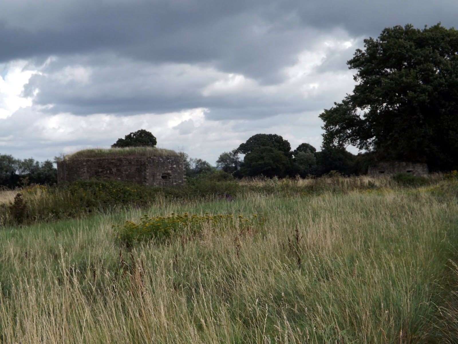
Along the river are several Pillboxes remaining from the Second World War. These provide a constant reminder when it was feared the river would be used as a route for invasion.


I now reach Eldridge 's Lock, where there is a canoe and fish pass installed.


I continue on along the river.


I now pass through Porters Lock again with a Canoe and Fish Pass.


 |
| Himalayan Balsam |
Himalayan balsam (Impatiens glandulifera) is a relative of the busy Lizzie, but reaches well over head height, and is a major weed problem, especially on riverbanks and waste land, but can also invade gardens. It grows rapidly and spreads quickly, smothering other vegetation as it goes.

 |
| More Pillboxes |
This is the first of a couple of places I saw with people being able to camp by the riverside.

 |
| Ford Green Bridge |
This iron bridge is used by walkers on The Wealdway, a Long distance walk of 80 miles from Gravesend to Beachy Head.
 |
| A tee-pee beside the river. |
 |
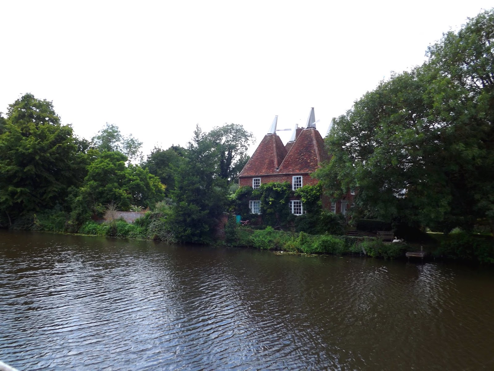
| Oast Houses in the distance. |


I now pass Oak Weir Lock.

I leave the river to cross over the Branbridge Road and into an Industrial Area, a vast contrast to the lovely walk so far.

I walk under the bridge that carries the A228 across.

 |
| A iron bridge that carries a railway line across The Medway |

Now the river scenery improves again as I approach Twyford and Yalding.

I walk pass a Oast House in Yalding, now a beautiful residence.

An Oast House is a building used to dry fresh hops before they are sent to the brewers, to be used for flavouring beer. A traditional Oast House consists of the 'oast' and the 'stowage'. The oast was a kiln, with a plenum chamber fired by charcoal at ground floor and the drying floor directly above. The steep pitched roof channelled the hot air through the hops to the top. The stowage, was the barn section, it had a cooling floor and press at first floor and storage area at ground floor.
Yalding is situated 6 miles (9.7 km) south west of Maidstone at a point where the Rivers Teise and Beult join the River Medway.
(meaning twin ford, where there was originally a double crossing of the two rivers) is one of the finest medieval bridges in the south-east of England. Yalding was one of the principal shipment points on the River Medway for cannon, from villages of the Wealden iron industry. One iron master was John Browne from Horsmonden.
The wharf was later used for transporting fruit from the many orchards in the area.
The Saxon village was called Twyford and was close to the bridge. But the name was recorded in the Domesday Book as the Saxon manor of Hallinges seized by William the Conquerer and given to his half brother Odo of Bayeux', Yalding was derived from the Olde English pre 7th century "Ealdingas" and translates as the place of the Ealda people a tribe who were widespread until the 9 the century (the old village). It was recorded in the "Domesday" as "Hallinges" by a Norman-French cleric who had little knowledge of the area. In 1212 it is recorded more correctly as "Ealding"
The medieval records from Yalding are so complete that it was used in a History Case Study for Secondary Schools, called The Yalding Project.
During the English Civil War in 1643, a battle took place at Town Bridge between the Roundheads and Cavaliers. The Cavaliers had advanced from Aylesford towards Tonbridge, but the Parliamentarian soldiers had marched to block their movements, bombarded them and forced their surrender, with the result that 300 were captured and 300 escaped.
Yalding was a favourite of Edith Nesbit, author of The Railway Children, who wrote in the 1920s: "The Medway just above the Anchor (at Yalding, Kent) is a river of dreams...If you go to Yalding you may stay at the George and be comfortable in a little village that owns a haunted churchyard, a fine church, and one of the most beautiful bridges in Europe."
The village was home to a chemicals manufacturing works from 1912 to 2003. In the early years it manufactured soap, then progressed to crop protection products. It was run by Syngenta at the time of closure.
Garden Organic, previously known as the Henry Doubleday Research Association, the UK's leading organic growing charity, created a demonstration garden near the village. This was closed in 2007 but was leased and reopened by the business Maro Foods, in 2008. The gardens are now known as the Yalding Gardens.


 |
| The Boathouse Pub |
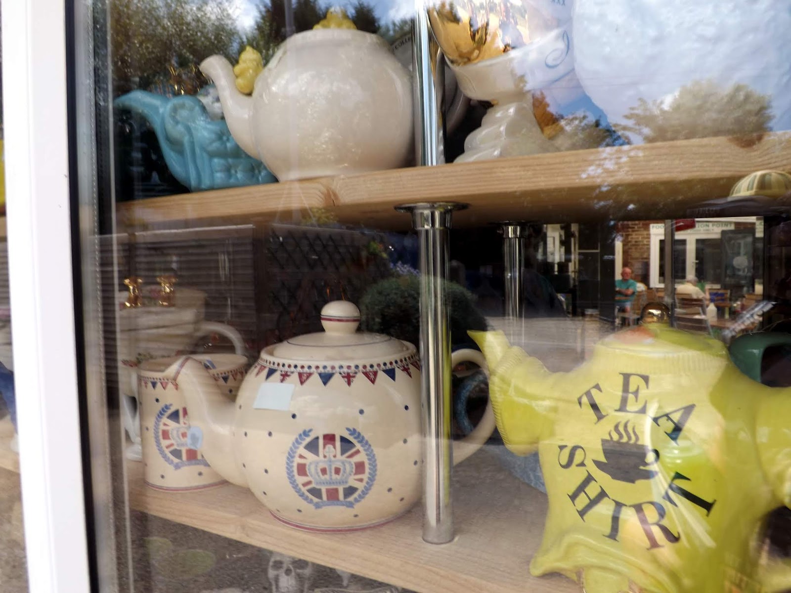
Now I reach Teapot Island, it came as a surprise. It was on my list to visit but I was unaware it would be on my walk today.

Teapot Island is a family run business that was established in Yalding in April 2003, housing the biggest collection of Teapots in England! With over 7600 teapots on display in our exhibition that is open to the public for a small charge.
They have over 2000 teapots for sale and also small mementos that you can purchase from our shop to take home.
In 2004 we started supporting the Kent Air Ambulance via our 3 metre tall Wishing Well teapot and cup and we currently hold two Guinness World Record certificates.
There has been a cafe on this site since the 1950s. It started its life as a tin shack serving tea and selling bait to the fisherman. It has changed a lot since then and they now boast a bistro style cafe, with a wide variety of different types of food on their menu and a big selection of ice creams. They are well known for our cream teas which boast scones, which are baked on the premises daily, real Cornish clotted cream, their own homemade jam and not forgetting of course a pot of tea.

After a quick stop for a Ice-cream I walk on through Yalding.

 |
| Twyford Bridge |

The path now turns away from the Medway and follows a Canoe Canal that was installed next to the Anchor Inn to direct watercraft alongside Hampstead Lane.


 |
| Alpaca's in a field alongside Hampstead Lane. |
Further up I cross a bridge and I now rejoin The River Medway.


 |
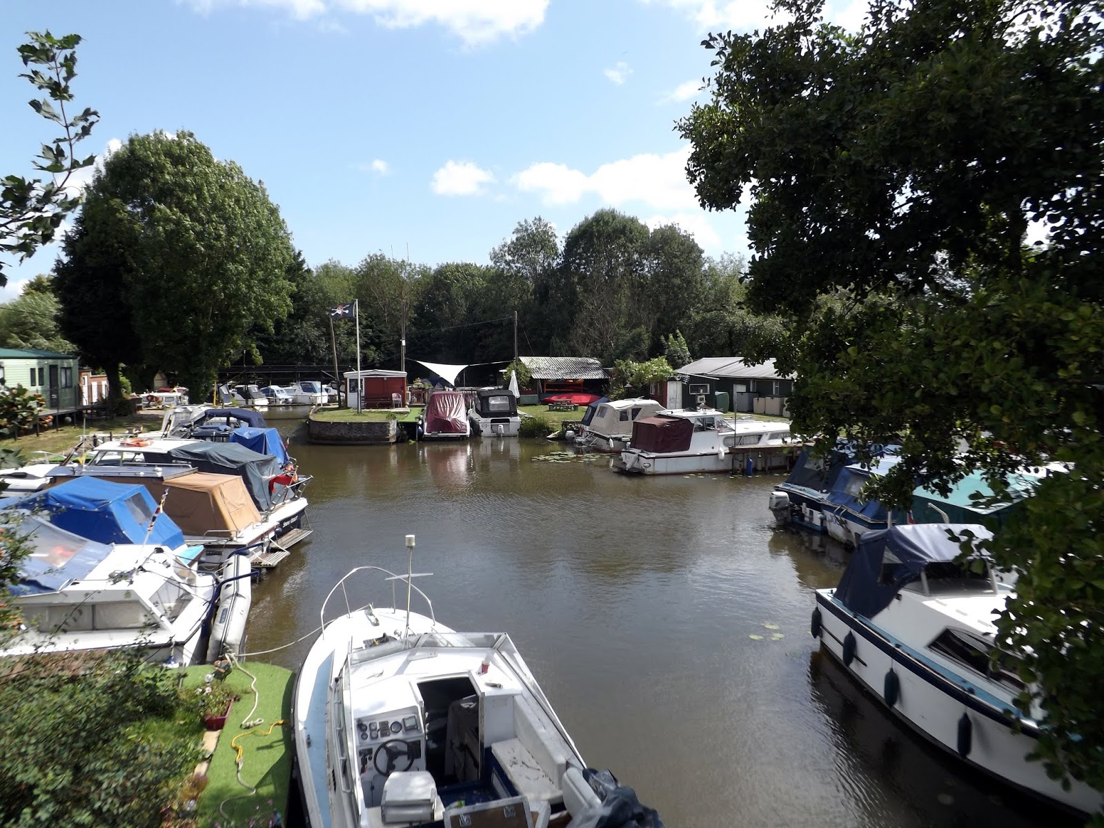
| Hampstead Marina Yalding |
 |
| Kenwood Trust Conference Centre. |
Kenward Trust is a rehabilitation centre for people recovering from alcohol and substance misuse issues.

As I walk further up I can see Nettlestead Place up above me, a medieval Manor House with a old stone gatehouse and 13th century undercoft.
Nettlestead Place appears to have been not unusual in this respect with the Saxon origin St Mary’s Church, immediately adjacent to it.
By the 12th Century, the manor was owned by the de Wahull family who were responsible for much of the medieval part of the house, including the stunning Undercroft which was built about 1250. Then in 1292 the de Pympe family took over from the de Wahulls until the 16th century when the house was passed by marriage into the Scott family.
Nettlestead Place was then abandoned during the second half of the 17th century. In 1913, the abandoned house was bought by Ronald Vinson who between 1920 and 1922 built onto the medieval range to make the house as it appears today
The present owners, Roy and Annabel Tucker have lived in Nettlestead Place since 1978 and have with much passion, rejuvenated and much extended the gardens and grounds.
There is a path that leads up the hill to St Marys Church but I was too tired and running low on time to go see it. It is a 15th century church.

I push on along the river towards Wateringbury.
The river is lined with boats and yachts here and a string of caravans along the bank.
The river is lined with boats and yachts here and a string of caravans along the bank.

The village name means Fortress by the river.

Wateringbury's existence is first documented in the 10th century will of Bihtric and Aelfswith and in the early 11th-century obligation recorded in the Textus Roffensis to maintain part of Rochester Bridge. The settlement had a detached 'den', used in autumn to feed pigs on acorns and nuts, in the forested Weald of Kent at Lilly Hoo, which remained a part of the parish for secular matters until the 19th century (and for ecclesiastical matters until the 20th century).


 |
| Wateringbury Train Station beside the river. |


I pass fields of horses and cattle as I approach Teston.


I am now at Teston Lock.

 |
| Barham Court |
Barham Court was once the home of Reginald Fitz Urse, one of the knights who murdered Thomas Becket in Canterbury Cathedralin 1170. As a result of that deed, Fitz Urse fled to Ireland and the manor passed into the ownership of his kinsman, Robert de Berham. The de Berham family (now called Barhams) became one of the great families in Kent.
At the end of Elizabeth I's reign, the property passed to Sir Oliver Boteler and his wife, Anne. The Botelers (later spelled Butler) were Royalists and Barham Court was sacked by Cromwell's New Army during the Civil War. William Butler, their son, was imprisoned in London for his support of the Kentish Royalist Petition of 1642, which indirectly led to the Battle of Maidstone 1648.
The last of the Butlers, Sir Philip, was responsible for rebuilding the parish church of St Peter and St Paul and changing the course of the old Tonbridge-Maidstone road, which used to run north of the church and then south of the house on its way to Barming and Maidstone. He had the road moved 'some hundred rods' (say five hundred and fifty yards) to the south. When Edward Hasted visited the house in the 18th century, then owned by the Bouverie family, he described it as the greatest ornament of this part of the county. After that it passed to the Charles Middleton, 1st Baron Barham and was the birthplace of his daughter and heir Diana, later Diana Noel, 2nd Baroness Barham.
William Wilberforce was a frequent house guest of the first Lady Barham, who is said to have inspired and supported him in his fight against slavery. He loved the place and once wrote that 'for the charm of softness and elegance I never beheld a superior to Barham Court'.
The house was very badly damaged in a fire in 1932. It was subsequently refurbished by Holloway Brothers. Today the house itself has been converted into offices, with apartments attached.
 |
| Teston Bridge |
I pass under Teston Bridge.

The bridge was constructed in the 14th or 15th century and comprises six arches of various heights and widths, the middle three of which span the river.
Three of the arches were rebuilt at the beginning of the 19th century and the parapet may also have been rebuilt. In 1749 the central arch was rebuilt at a cost of £225 12S 4d to provide access for barges.


I follow the river past more herds of cattle, one decided it would move towards me and bellowing. I said to it "Shut up" and it stopped and did as it was told.


Up above me and beyond the railway line was St Margarets at Barming. Another Norman church dating from the 12th century. It stands among orchards and separated from the village it serves.
 |
| St Margarets, Barming |
 |
| More riverside camping |


I am now approaching East Farleigh and my feet are now tired.


I arrive back in East Farleigh and I cross the bridge again to return to my car.


Including the look about East Farleigh earlier this was about a 15 mile walk.

Next up Pt 2 the final stretch, East Farleigh to Rochester. Hopefully I'll complete this in the not too distance future.
Read Part 2 here
Read Part 2 here