Sunday, 6 September 2020

The Four Waterfalls Walk,Brecon Beacons South Wales 5th September 2020

On Saturday the 5th September 2020, I left my campsite near Porthcawl for the drive to Cwm Porth car park near Ystradfellte in the Brecon Beacons to walk the Four Waterfalls walk.

GPX File here
Viewranger File here

NOTE: Our path follows a footpath later on that's sign posted Dangerous, so make your own decision if you wish to follow my route. You do so entirely at your own risk.

We parked up and paid the £4 to park, normally you need the £4 in coins for the meter but due to covid they are only accepting payment by card. I was here just gone 9am, get here early as it fills up quickly. NOTE: This is called Cwm Porth car park and not Four Falls Waterfall Hike Car Park 2 as navigated to by Google maps.Got confused on the walk as there are no signs for Car Park 2       (CF44 9JF).

We left the car and set off across the road to follow the trail towards our first waterfall.


We follow a well maintained footpath towards Sgwd yr Eira (“SGOOD uhr ehr-uh”) on the Afon Hepste (Hepste River).

Here we found stunning views across the Brecon Beacons National Park.


We now reach the 170 odd steps down to Sgwd yr Eira.

Meaning Snow Waterfall in Welsh, Sgwd yr Eira is part of the Four Falls Walk. Situated between the villages of Hirwaun, Ystradfellte and Pontneddfechan, north-west of Merthyr.

The site itself is of massive national and international environmental importance and receives around 160,000 visitors a year. Part of Fforest Fawr, a European and UNESCO Geopark, Waterfall Country is famous for its wooded gorges, caves, swallow holes and waterfalls, as well as oak and ash trees and more than 200 species of mosses, liverworts and ferns.


Sgwd yr Eira - Famous for being the falls behind which you can walk, the 'falls of snow' plunge over a hard band of sandstone whose overhang protects the walker from the full force of the water.


The sound of the gushing water was amazing and the spray meant you were getting wet whether you like it or not!


This is the most spectacular of the four falls.


After walking behind the falls, we stopped a little bit up the river for lunch before tackling the 170 odd steps back up to the top.

Once back up, after a short rest at the top we continued along the route and now take a path down to Sgwd y Pannwr (“SGOOD uh PAN-noor”).


This was a long path down,not steep at first but got steeper towards the bottom.

Sgwd y Pannwr - The 'fall of the fuller' or 'fall of the woollen washer' is the lowermost of the three celebrated falls on the Mellte.


I was able to sit on a ledge and watch the Afon Mellte spread out over its ledge as the waterfall then plunged into a dark pool below me. I was looking for a way to get down to the pool for a swim, but could see no safe route.


So no safe route to the pool, I sat by the River Mellte and dipped my feet in the freezing water.

After a rest and drink. We decided not to walk all the way back up the path to the safe Tourist path, but instead follow the river to the next waterfall and prevent the climb up again.

After a short distance we reached our third Waterfall, Sgwd Isaf Clun-Gwyn (“SGOOD ee-sahv clin-goo-un”).

Sgwd Isaf Clun-Gwyn - The 'lower fall of the white meadow' is the middle of three falls.

We sat here for a bit watching people leap into the falls as part of a Gorge walking trip.

We were about to leave, but I knew I'd regret it if I didn't go in for a swim. My wife didn't want mew to go in saying its too busy with people. But I have perfected the art of getting changed beneath a towel, and was in swimming within minutes.


What a beautiful swim too, and not as cold as I'd have thought.


After my swim, I got changed and now followed the dangerous path up the cliff that required a bit of scrambling and hands on the rocks to climb.

Please if you are not confident on this type of path or you have kids or dogs with you, follow the main tourist path!


The path became very narrow with a drop below,so we carefully made our way along to the next waterfall. 

Afon Mellte


We pass a sign telling us the path we were on was dangerous, I saw no sign warning us of this from the other direction.


We now reach Sgwd Clun-Gwyn (“SGOOD clin-goo-un”), our fourth and final Waterfall.

Sgwd Clun-gwyn - The 'fall of the white meadow' is the uppermost of the three celebrated falls on the Mellte. It is formed where a north-northwest to south-southeast trending fault brings hard sandstone up against softer mudstone.

In terms of the Welsh meanings, apparently in South Wales, a lot of waterfalls had the name sgwd meaning “cascade” as opposed to rhaeadr meaning “waterfall” (which you see a lot of in North Wales).


We leave the fall behind. Now we come to a wooden bridge, and none of the signs say Four waterfalls Walk Car Park 2 that I had navigated to using Google maps. So I crossed the bridge and walked on by the Sgwd Clun-Gwyn fall again on the other side.
After a while I realised our mistake and my initial gut feeling was right we needed to follow the Cwm Porth car park signs. So we walked back crossing the bridge again and followed the river.


After much walking we passed the sign for the caves, but at this point didn't fancy thew detour so we arrived back at the car park at just under 5 miles delightful miles of beautiful waterfall country. So glad we decided to walk this route.


Trip to Barry Island (Ynys y Barri), South Wales (Gavin and Stacey Country) and then onto Porthcawl, 4th September 2020

On the 4th September 2020 I set off from home and after just over 3 and a half hours drive, my wife and I arrive at Barry Island in the Vale of Glamorgan South Wales. 

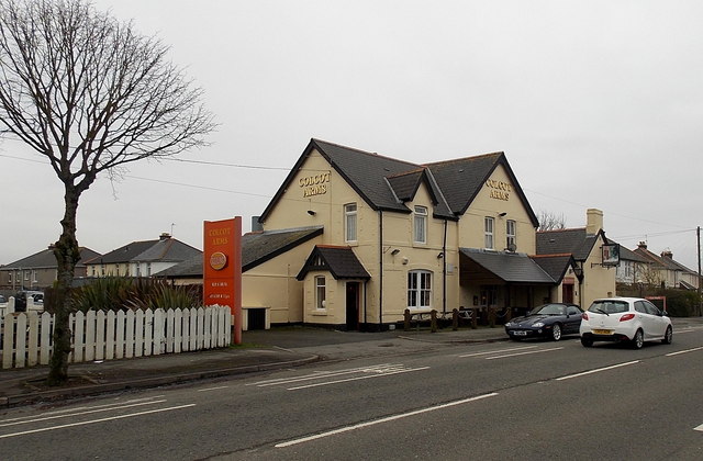
As we drive in we pass the Colcott Arms,the Colcot Arms is set in Billericay – it's the local pub in which Smithy hosts his pub quiz.

File:Colcot Arms, Barry - geograph.org.uk - 3286004.jpg - Wikipedia
First stop was to drive to 47 Trinity Road the location of Stacey's House from the BBC show 'Gavin and Stacey' where she lives with her Mum Gwen West.

Across the road at 48 is Uncle Bryns House, been nice to knock and ask what happened on that camping trip!


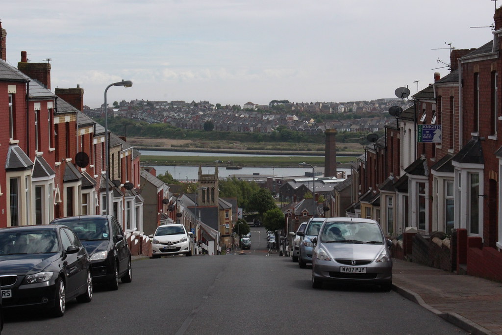
Trinity Street, Gavin and Stacey
View down Trinity Street to Barry Island.

We drive down to Barry Island and paid the £6 for a days parking. Shame only options was 1 hour or day!


We are on the seafront of Barry Island or ‘Barrybados’, as it’s affectionately been nicknamed by the locals. In the 20th century it was home to a thriving Butlins holiday resort and pleasure park filled with amusement rides. After a period of decline, Barry Island has been redeveloped with a new seafront and investment into the pleasure park.

The holiday camp was used to film scenes in the "Shangri-La" holiday camp in the Doctor Who serial Delta and the Bannermen. The island was also a location for Doctor Who in the 2005 series episodes "The Empty Child" and "The Doctor Dances", standing in for a bomb site in 1941 London and the 2014 series episode "Flatline".

Tourism has had a further boost in recent years thanks to the hit BBC television series Gavin and Stacey, set in the nearby town of Barry with the beach front frequently popping up in episodes. Over the road from the beach are a variety of gift shops selling souvenirs based around the hit series.


Stacey works at Marco's cafe, which is a real cafe on the front; across the road is where Nessa works at the arcades. The gang plonk themselves on the beach right in front of the Western Shelter by Boofy's and O'Shea's chippies (yum) and it's the place where Gav meets Stacey off the bus after their first meeting in London.

Marco' Cafe, where Stacey works.

The recently refurbished seafront now offers a sweeping promenade along the entire length of Whitmore Bay beach, against a backdrop of enticing cafés and restaurants, beach wheelchairs available to loan, vibrant beach huts and lots to amuse the kids with a climbing wall, mist feature, adventure golf and beautiful landscaped gardens. Or for the more adventurous, Barry Island Pleasure Park offers thrilling rides.

We take a walk along the sandy beach that featured a few times in the BBC show.

The peninsula was an island until the 1880s when it was linked to the mainland as the town of Barry expanded. This was partly due to the opening of Barry Docks by the Barry Railway Company. Established by David Davies, the docks now link up the gap which used to isolate Barry Island.


The area around Barry Island shows extensive evidence of human occupation. Mesolithic or Middle Stone Age microlith flint tools have been found at Friars Point on Barry Island and near Wenvoe, and Neolithic or New Stone Age polished stone axe-heads were discovered in St. Andrews Major. As the area was heavily wooded and movement would have been restricted, it is likely that people also came to what was to become Wales by boat, apparently from the Iberian Peninsula. They cleared the forests to establish pasture and to cultivate the land.

These neolithic colonists, who integrated with the indigenous people, gradually changed from being hunter-gatherers to settled farmers. They built the long barrows at St Lythans and Tinkinswood, which date to around 6,000 BP, only 3 miles (4.8 km) and 4 miles (6.4 km) to the north of Barry Island, respectively.
In common with the people living all over Great Britain, over the following centuries the local population assimilated immigrants and exchanged ideas of the Bronze Age and Iron Age Celtic cultures. Together with much of South Wales, Barry Island was settled by a Celtic British tribe called the Silures. There have been five Bronze Age burial mounds, or cairns, recorded on Friars Point.
Although the Roman occupation left no physical impression on Barry Island, there were Romano-British settlements nearby in Barry and Llandough. These people embraced the Roman religion of Christianity and dedicated a chapel to St Baruc, a disciple of St Cadoc. Having forgotten to bring St Cadoc's reading matter with him, on a journey from the island of Flat Holm, St Baruc was sent back and he drowned in the Bristol Channel on the return journey. He was buried on Barry Island and the ruins of the chapel that was dedicated to him can still be seen in Friars Road. His feast day is on 27 September.
The Vikings launched raids in the area and Barry Island was known to be a raider base in 1087.


We walk from Whitmore bay and onto Little Island and up to the top.


We walk back to the seafront and visit  Island Leisure Amusement Arcade, Western Shelter. This is where Nessa worked in the change booth.


We walked back towards the car and stopped for breakfast in Romys cafe. This was the worst breakfast we've had in our lives! Cooking bacon bit, disgusting other bits and a old mushroom doing a backstroke in the oil! Avoid avoid, wish we'd gone elsewhere, was ill later that night!

We leave Barry and drive to our campsite Brodawel Campsite in Nottage, just outside Porthcawl.


Lovely site, just make sure you've got a pitch away from the toilet block, that had a waft of sewage in the air.

So after setting up we drove a short way up the road to Porthcawl and found a free spot to park on West Drive and we walked back into town.

Porthcawl is Historically part of Glamorgan and situated on a low limestone headland on the South Wales coast, overlooking the Bristol Channel, Porthcawl developed as a coal port during the 19th century, but its trade was soon taken over by more rapidly developing ports such as Barry. Northwest of the town, in the dunes known as Kenfig Burrows, are hidden the last remnants of the town and Kenfig Castle, which were overwhelmed by sand about 1400.


Porth is a common Welsh element, here it means harbour, but the second element is disputed. Local tradition states that cawl is a corruption of Gaul, and that the area was an ancient landing point for Gaulish and Breton, or later Frankish and Norman knights.A modern, if unlikely, interpretation is Cawl harbour.

Porthcawl, like many British resorts, has suffered a decline in its holiday trade over recent years, especially since most of the South Wales Valleys coal pits closed. A major feature of the summer was the miners' fortnight, when large numbers of miners took their annual break.

Harbour Quarter


Porthcawl Lifeboat Station, purpose-built in 1995, is situated near the harbour. The station operates an inshore B class Atlantic 85 lifeboat and a D class IB1. 'Cosy Corner' is a park area, which over the years has housed a theatre, cinema, roller skating rink and ballroom. The Jennings Building, built in 1832, is a grade II listed building and Wales' oldest maritime warehouse, and is currently vacant. The building has been identified as a potentially important facility as part of the Porthcawl Regeneration Strategy.

At the end of Porthcawl Pier stands a white lighthouse built in 1860. The lighthouse is currently in use as a navigational aid. Porthcawl Lighthouse was the last coal and gas-powered lighthouse in the UK. It switched to being powered by North Sea gas in 1974, before becoming powered by electricity in 1997. The pier and surrounding area are popular spots for sea fishing.

The historic ships the PS Waverley, the last seagoing paddle steamer in the world, and the MV Balmoral sail from this area during the summer months.


Tourist attractions in the area include sandy beaches, a grand pavilion, a funfair named Coney Beach (modelled on Coney Island in New York), a museum and three golf courses.


We head back to the site and then head into Nottage, where I had a pint in the Farmers Arms and a bowl of chips.

We then walked around to the Swan Inn for another pint before the half mile walk back to site.


A good day in not so good weather, but a great day planned for the next day walking the Four Waterfalls walk!