Monday 9 October 2017

Ingrave,Thorndon Country Park,Herongate circular walk 9th October 2017

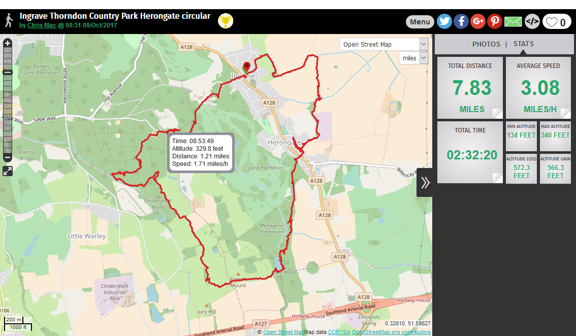
On Monday the 9th of October 2017 I set off from home for a local walk with my Labrador Ben.I drove to Ingrave, Brentwood,Essex. Here I parked up in St Nicholas Grove and crossed the busy Brentwood Road into Thorndon Gate.

Ingrave's name is derived from that of the original manor in this area, "Ging-Ralph" or "Ralph’s-ing".

Here I pass an house with what appears to be a chapel, but can not find any information on this.

I walk down the road that leads to the Golf Course and Thorndon Hall. At the end of the road I take a footpath that leads between the road to the course and the hall.

I pass by Thorndon Hall.
Thorndon Hall is a Georgian Palladian country house within Thorndon Park, Ingrave, Essex.
Formerly the country seat of the Petre family who now reside at nearby Ingatestone Hall, the house is located within nearly 600 acres (240 ha) of ancient medieval deer park, meadows and forest. The garden is designed by Capability Brown.
Thorndon Hall is Grade-I listed with English Heritage, and the park is Grade II*-listed.

 The estate of Thorndon Hall, known previously as the manor of West Horndon, can trace its records back to the 1086 Domesday Survey commissioned by William the Conqueror. However, a building on the site of Old Thorndon Hall was first recorded in 1414 when King Henry V of England gave licence for its new owner, a merchant from South Wales called Lewis John, to "empark 300 acres (120 ha), to surround his lodge within this park with walls and to crenellate and embattle the lodge". The current house replaced Old Thorndon Hall which was located about a mile to the south in what is now known as "ruin wood" next to Old Hall pond. The old hall was damaged by fire in the early 18th century and was subsequently pulled down after being used briefly as farm buildings

The present house was designed by the fashionable neoclassical architect James Paine and construction started in 1764. The portico of the present house was originally commissioned and imported from Italy in 1742 for use on the old hall which had been remodelled by Giacomo Leoni in the Palladian style. Following the fire at the Old Hall, it was kept, and reused in the design of the present house.
The estate and newly finished house was visited in 1778 by King George III and Queen Charlotte on their visit to see the troops at nearby Warley Common.
Following a fire in 1878, much of the main house and west wing were gutted leaving a shell and destroying or damaging many of the Petre picture collection. The surviving east wing was adapted into partial residential use with plans to renovate the house back to its original grandeur. However Petre family finances were in a poor state after the Great War and in 1920 the house and a portion of the estate was leased to Thorndon Park Golf Club. Originally, the company had planned to develop the estate into a luxury housing development and golf course, much the same as the Wentworth Club and St. George's Hill in Surrey, but with the introduction of London green belt legislation limiting house building on farm and parkland, the plan could not go ahead and the company folded.

 Eventually the golf club acquired the house and grounds, but chose to move out of the main hall and construct its purpose-built clubhouse within the grounds. In 1976, Thorndon Hall was sold to a developer, Thomas Bates & Son, Romford, who converted the mansion sympathetically to luxury apartments and cottages in landscaped surroundings, woodlands and parkland. Parts of the former park had been sold off during the twentieth century for development on the outskirts of Brentwood. Essex County Council manages extensive areas as the public Thorndon Country Park. The nearby Petre family mortuary chapel is now owned by the Historic Chapels Trust.

I walk on through Thorndon Country Park and its woodlands.

I walk on through and along a road where I reach Thorndon Park Chapel
The chapel was built as a private chantry chapel and mausoleum for the Roman Catholic Petre family who lived in Thorndon Hall. It was built in about 1850, and dedicated in 1857. The architect was William Wardell. Having become redundant and subject to decay and deterioration, the chapel was given to the Trust by Lord Petre in 2010.

Constructed in Kentish ragstone with freestone dressings, the chapel has a tiled roof. Its architectural style is Decorated. The plan of the chapel is L-shaped in three bays, with a vestry and a bellcote on the south side. On the sides of the chapel are buttresses and two-light windows. At the west end is an arched doorway, with carvings in the spandrels, above which is a large three-light window containing curvilinear tracery. The east window is similar. The bellcote is attached to the south wall and consists of an octagonal stair turret, an octagonal highly decorated bell stage with lancet bell openings, and a pyramidal roof. Inside the church is an elaborately decorated roof, including gilded angels. Around the walls of the chapel are the Stations of the Cross on stone panels. The stone altar is integrated into the east wall, with a richly carved reredos above it. Some of the stained glass was made by Hardman, but has been moved into storage.


I walk on through the park and woodland before taking a path that leads me up to Jury Hill.

On a clear day, you can see over the Thames Plain to the Queen Elizabeth II Bridge and Canary Wharf.


The path is blocked!
I carefully walk past the cows with Ben on his lead, hoping neither make any unexpected moves.


I walk along the path and see an mound, upon reading the nearby sign I find out its past.


The Pigeon Mount in Thorndon Park South was once the base of an elaborate octagonal tower and was the central feature of a large walled orchard. The mound had a spiral path leading to its door and from the tower there were spectacular views over the Thames Estuary. The tower may have had two uses - either a summer house for sitting and drinking tea when visiting the garden of nearby Thorndon Hall, or as a dovecote for keeping pigeons.

The tower has long gone and only the mound remains.


I pass Old Hall Pond that is a day ticket water, I fished here many many years ago myself!


Ben and I leave Thorndon Country Park and walk back across Brentwood Road to The Green Man PH in Herongate.

The Green Man PH is a traditional village pub dating back to the 17th century, the Grade II listed Green Man counts oak-beamed ceilings and inglenook fireplaces among its original features.Once a family home, then a greengrocer’s shop before becoming a pub.

I walk along Cricketers Lane, a lane of beautiful cottages. I walk too far missing the footpath and have to backtrack.


A old 1968 Porsche parked by the Green Man PH


Now back on track I walk down a private road that the footpath follows, passing some big houses.


At the end of the private road I turn left by the gates that leads to what appears to be a sewage or water treatment centre.

I follow this path along side the fences before it heads out into some farmland. 


This path eventually leads me back to my car parked in St Nicholas Grove after a 8 mile walk!


GPX File here........... http://www.haroldstreet.org.uk/routes/download/?walk=3093

Monday 25 September 2017

Chartwell House,Toys Hill,Ide Hill and Emmets Garden Circular 25.09.2017

I set off from home in the rain, and arrived at Chartwell House a little after 9am. The house doesn't open until 10am so I parked up (Free for NT members otherwise a charge) in the car park.
I walked out onto Mapleton Road turning left towards Four Elms.


My Viewranger track here..please click

I follow the road for a while before turning left onto a track that leads past some fields and an orchard.


At the end of this track I reach Oast Tops at Chartwell Farm.
Oast Tops is three round kiln oast houses with Stone built walls,Converted in 2010.

One of two adjacent oast houses, along with Dairy Oast, which were once part of Chartwell Farm.

As I walked further along the track Pheasants were flying out of every place I walked by, they were everywhere.

I walk on through Buddles Wood before exiting onto Puddledock Lane.
This road climbs steeply over quite a distance, I have certainly warmed up now.
View over the Weald of Kent
At the top of this Hill is Toys Hill Well.


Another fantastic Viewpoint

I reach the end of Puddledock Lane where it meets Toys Hill Road, here I take a footpath on my left up another steep hill.


The highest point of the Kent Downs! Toys Hill is more than 450 acres (180 hectares) of woodland, cared for by the National Trust. Enjoy the fine views over the Weald and discover the diverse and abundant wildlife which makes this area a Site of Special Scientific Interest (SSSI).
For hundreds of years, Toys Hill was a vital part of the local economy. Charcoal burners, herdsman and local villagers would have gathered firewood and grazed their livestock here. Charcoal pits can be seen on the orange route and the pollarded trees on the disabled access route. Pollarding is an ancient way of managing woodland which is grazed.
The hill used to be well known for its groves of ancient beech pollards, dating back to the early days of grazing. You can still see a few which survived the 1987 storm. The woods are regenerating after the storm; look for the sessile oak, beech and birch saplings on the plateau. Parts of Scords Wood are managed on a non-intervention ‘hands off’ basis so that natural development after the storm can be studied by Natural England. The bridle path, green and red routes lead through this area which has become rich in insects and fauna.


I reach a car park at the top of the hill, which I walk through before crossing Toys Hill Road and across into Scords Wood opposite.


As I leave Scords Wood I have more amazing views across The Weald of Kent.


I can now see my next climb up to Ide Hill.


St Marys Church at Ide Hill.


At the top of the hill I exit onto Sundridge Lane and walk up to the village green.

There are several old buildings round the sloping village green, including the 18th-century Cock Inn and the Ide Hill Village School, built in 1856 it is the second home of the school which unusually for a church school predates the church building as the school was formed in 1809.


Ide Hill is a village within the civil parish of Sundridge with Ide Hill, in the Sevenoaks District of Kent, England. It stands on one of the highest points of the sandstone ridge about five miles south-west of Sevenoaks. Its name first appears on record in 1250 as Edythehelle. It is an eponymic denoting 'Edith's hill', from the Old English hyll 'hill'.


I reach St Marys Church, The Highest church in Kent.


The church is relatively modern. The village had an Anglican chapel in 1807, built by Beilby Porteus, Bishop of London, who lived in nearby Sundridge; St Mary's church was built in 1865 and "has the distinction of being the highest church in Kent" [The Kent Village Book] at 216 metres above sea level, as well as boasting a beautiful lychgate, crafted by local builder Cecil 'Dusty' Boakes.


I walk back down Sundridge Road passing the school and many lovely cottages.


Old School House a grade II listed building. C18 or earlier 2-storey, 2-window timber framed cottage.


After walking a bit along the road I turn left up a track and past a cricket green.


This Track leads me up to the NT Emmetts Garden.

Emmetts Garden was open farmland until 1860 when the present house was built. The name 'emmett' is a local word for ant and refers to the giant anthills that covered the area until the 1950s. The house and land was purchased in 1890 by Frederic Lubbock, a banker and passionate plantsman. Lubbock's elder brother was John Lubbock, 1st Baron Avebury, coincidentally a world expert on ants, which may have influenced his decision to purchase the property.

The gardens were initially laid out between 1893 and 1895 under the influence of Lubbock's friend William Robinson in the fashionable Edwardian style popularised by Gertrude Jekyll. The shrub garden was added later in 1900-1908.
After Lubbock's death (1927), the estate was acquired by an American geologist Charles Watson Boise. He made various alterations to both house and garden but retained the original character of the gardens.

In 1964 Charles Boise bequeathed Emmetts to the National Trust. Since then the Trust has sought to maintain the botanical diversity of the garden developed by the two men.
Many of the old trees and shrubs planted by Lubbock were brought down in the Great Storm of 1987. Following the storm, which had the benefit of bringing more light to the gardens, the National Trust has undertaken a sympathetic replanting programme.

The garden, which covers an area of about six acres (approximately 2.5 hectares), occupies a commanding site on a 600-foot (180 m) sandstone ridge, overlooking the Weald. One of the highest points in Kent, it offers expansive views towards the North Downs.
It is mainly planted with trees and shrubs in the form of an arboretum; a magnificent 100-foot (30 m) Wellingtonia (Giant Sequoia) fortunately survived the Great Storm. There is also a rose garden located next to the Victorian house to which the gardens once belonged. The house is not open to the public.


After much wandering about these beautiful gardens, I stop in the Tea room for tea and a slice of Coffee cake.


I now continue with my walk,back through Scords wood in The Chart.


I leave Scords Wood and cross Emmetts Lane and back into Scords Wood opposite. 


I leave Scords Wood and head down a lane towards French Street.


I walk pass more lovely cottages in the small hamlet of French Street.


After more walking  along the Greensand way through woods, I am back at Chartwell House.

I get my timed ticket for 1250 hrs to visit the house and proceed through the houses grounds.

Swimming Pool
In the early years, the Churchills used the lakes for swimming until the oval concrete pool was constructed in the 1930s. With his usual thoroughness, Churchill took the advice from his scientist friend, Lindemann, on the amount of water needed to fill it and from a chemist on the correct chemicals to keep it clean.

Huge Gunnera plants


Swimming Pool


Golden orfe ponds

Churchill first encountered golden orfe in the 1930s and was so entranced by them that they were made features of the Chartwell garden. Have a look out for a small chair next to one of the ponds; Churchill could sit here for hours in silent contemplation as he feed his beloved fish.


For over forty years Chartwell was the home of Winston Churchill. He bought the property in September 1922 and lived there until shortly before his death in January 1965. In the 1930s, when Churchill was excluded from political office, Chartwell became the centre of his world. At his dining table, he gathered those who could assist his campaign against German re-armament and the British government's response of appeasement; in his study, he composed speeches and wrote books; in his garden, he built walls, constructed lakes and painted. During the Second World War Chartwell was largely unused, the Churchills returning after he lost the 1945 election. In 1953, when again Prime Minister, the house became Churchill's refuge when he suffered a devastating stroke. In October 1964, he left for the last time, dying at his London home, 28, Hyde Park Gate, on 24 January 1965.
The origins of the estate reach back to the 14th century; in 1382 the property, then called Well-street, was sold by William-at-Well. It passed through various owners and in 1836 was auctioned, as a substantial, brick-built manor. In 1848, it was purchased by John Campbell Colquhoun, whose grandson sold it to Churchill. The Campbell Colquhouns greatly enlarged the house and the advertisement for its sale at the time of Churchill's purchase described it as an "imposing" mansion. Between 1922 and 1924, it was largely rebuilt and extended by the society architect Philip Tilden. From the garden front, the house has extensive views over the Weald of Kent, "the most beautiful and charming" Churchill had ever seen, and the determining factor in his decision to buy the house.

In 1946, when financial constraints forced Churchill to again consider selling Chartwell, it was acquired by the National Trust with funds raised by a consortium of Churchill's friends led by Lord Camrose, on condition that the Churchills retain a life-tenancy. After Churchill's death, Lady Churchill surrendered her lease on the house and it was opened to the public by the Trust in 1966. A Grade I listed building, for its historical significance rather than its architectural merit, Chartwell has become among the Trust's most popular properties; some 232,000 people visited the house in 2016, the fiftieth anniversary of its opening.

Churchill Portrait


Vistors Book, including signatures from President Truman, amongst many others


I was told off, apparently I was not allowed to take photos inside the building!


After World War II, Chartwell was bought by a group of friends and admirers of the Churchills to be given to the National Trust upon Sir Winston’s death. This extraordinary gesture alleviated most of the mortgage woes and inheritance details the Churchills worried about for their children. For years, the identity of the group of donors remained a secret, but today, the names of these men and their generous gift are celebrated on a plaque on the Chartwell grounds.


Lady Churchill's rose garden

The present walled rose garden on the north side of the house was designed by Clementine's close friend and cousin Venetia Montagu. Together they created a traditional, formal English rose garden divided by paths into four beds and softened by a mass of perennials and shrubs in gentle colours. The roses may not be out yet, but the garden remains a place of quiet contemplation.

Leaving the house, I wandered around the grounds and the Kitchen Garden.


The studio is home to a collection of Churchill's paintings that have been saved for the nation to see and enjoy.


Playhouse built for Churchill's youngest daughter Mary


Kitchen garden

I head to the kitchen garden to see the wall that Churchill built with his own hands. Using the old diaries of Churchill's head gardener and surviving invoices of seed purchases, the National Trust recreated something like the appearance of the productive kitchen garden as the Churchills knew it. Much of the produce grown heads over to the café to be used in delicious dishes.


I now head back to the car after a 10 mile walk. I drive back along the road to where I walked earlier and saw the alpaca or Llamas (I can never tell the difference) before the drive home.


GPX File here............ http://www.haroldstreet.org.uk/routes/download/?walk=3094