Sunday 6 September 2020

Trip to Barry Island (Ynys y Barri), South Wales (Gavin and Stacey Country) and then onto Porthcawl, 4th September 2020

On the 4th September 2020 I set off from home and after just over 3 and a half hours drive, my wife and I arrive at Barry Island in the Vale of Glamorgan South Wales. 

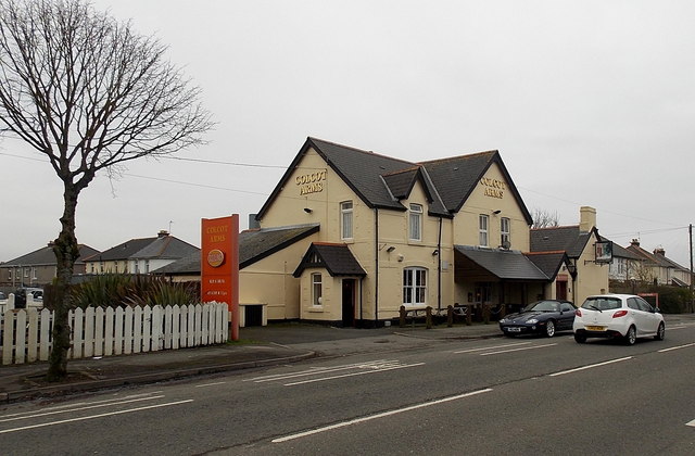
As we drive in we pass the Colcott Arms,the Colcot Arms is set in Billericay – it's the local pub in which Smithy hosts his pub quiz.

File:Colcot Arms, Barry - geograph.org.uk - 3286004.jpg - Wikipedia
First stop was to drive to 47 Trinity Road the location of Stacey's House from the BBC show 'Gavin and Stacey' where she lives with her Mum Gwen West.

Across the road at 48 is Uncle Bryns House, been nice to knock and ask what happened on that camping trip!


Trinity Street, Gavin and Stacey
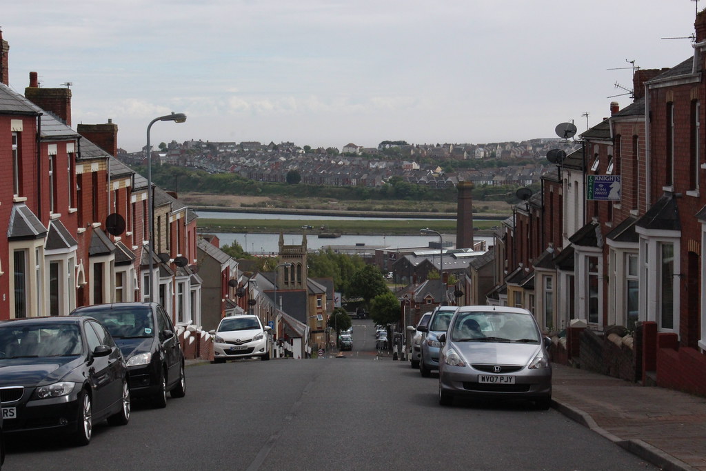
View down Trinity Street to Barry Island.

We drive down to Barry Island and paid the £6 for a days parking. Shame only options was 1 hour or day!


We are on the seafront of Barry Island or ‘Barrybados’, as it’s affectionately been nicknamed by the locals. In the 20th century it was home to a thriving Butlins holiday resort and pleasure park filled with amusement rides. After a period of decline, Barry Island has been redeveloped with a new seafront and investment into the pleasure park.

The holiday camp was used to film scenes in the "Shangri-La" holiday camp in the Doctor Who serial Delta and the Bannermen. The island was also a location for Doctor Who in the 2005 series episodes "The Empty Child" and "The Doctor Dances", standing in for a bomb site in 1941 London and the 2014 series episode "Flatline".

Tourism has had a further boost in recent years thanks to the hit BBC television series Gavin and Stacey, set in the nearby town of Barry with the beach front frequently popping up in episodes. Over the road from the beach are a variety of gift shops selling souvenirs based around the hit series.


Stacey works at Marco's cafe, which is a real cafe on the front; across the road is where Nessa works at the arcades. The gang plonk themselves on the beach right in front of the Western Shelter by Boofy's and O'Shea's chippies (yum) and it's the place where Gav meets Stacey off the bus after their first meeting in London.

Marco' Cafe, where Stacey works.

The recently refurbished seafront now offers a sweeping promenade along the entire length of Whitmore Bay beach, against a backdrop of enticing cafés and restaurants, beach wheelchairs available to loan, vibrant beach huts and lots to amuse the kids with a climbing wall, mist feature, adventure golf and beautiful landscaped gardens. Or for the more adventurous, Barry Island Pleasure Park offers thrilling rides.

We take a walk along the sandy beach that featured a few times in the BBC show.

The peninsula was an island until the 1880s when it was linked to the mainland as the town of Barry expanded. This was partly due to the opening of Barry Docks by the Barry Railway Company. Established by David Davies, the docks now link up the gap which used to isolate Barry Island.


The area around Barry Island shows extensive evidence of human occupation. Mesolithic or Middle Stone Age microlith flint tools have been found at Friars Point on Barry Island and near Wenvoe, and Neolithic or New Stone Age polished stone axe-heads were discovered in St. Andrews Major. As the area was heavily wooded and movement would have been restricted, it is likely that people also came to what was to become Wales by boat, apparently from the Iberian Peninsula. They cleared the forests to establish pasture and to cultivate the land.

These neolithic colonists, who integrated with the indigenous people, gradually changed from being hunter-gatherers to settled farmers. They built the long barrows at St Lythans and Tinkinswood, which date to around 6,000 BP, only 3 miles (4.8 km) and 4 miles (6.4 km) to the north of Barry Island, respectively.
In common with the people living all over Great Britain, over the following centuries the local population assimilated immigrants and exchanged ideas of the Bronze Age and Iron Age Celtic cultures. Together with much of South Wales, Barry Island was settled by a Celtic British tribe called the Silures. There have been five Bronze Age burial mounds, or cairns, recorded on Friars Point.
Although the Roman occupation left no physical impression on Barry Island, there were Romano-British settlements nearby in Barry and Llandough. These people embraced the Roman religion of Christianity and dedicated a chapel to St Baruc, a disciple of St Cadoc. Having forgotten to bring St Cadoc's reading matter with him, on a journey from the island of Flat Holm, St Baruc was sent back and he drowned in the Bristol Channel on the return journey. He was buried on Barry Island and the ruins of the chapel that was dedicated to him can still be seen in Friars Road. His feast day is on 27 September.
The Vikings launched raids in the area and Barry Island was known to be a raider base in 1087.


We walk from Whitmore bay and onto Little Island and up to the top.


We walk back to the seafront and visit  Island Leisure Amusement Arcade, Western Shelter. This is where Nessa worked in the change booth.


We walked back towards the car and stopped for breakfast in Romys cafe. This was the worst breakfast we've had in our lives! Cooking bacon bit, disgusting other bits and a old mushroom doing a backstroke in the oil! Avoid avoid, wish we'd gone elsewhere, was ill later that night!

We leave Barry and drive to our campsite Brodawel Campsite in Nottage, just outside Porthcawl.


Lovely site, just make sure you've got a pitch away from the toilet block, that had a waft of sewage in the air.

So after setting up we drove a short way up the road to Porthcawl and found a free spot to park on West Drive and we walked back into town.

Porthcawl is Historically part of Glamorgan and situated on a low limestone headland on the South Wales coast, overlooking the Bristol Channel, Porthcawl developed as a coal port during the 19th century, but its trade was soon taken over by more rapidly developing ports such as Barry. Northwest of the town, in the dunes known as Kenfig Burrows, are hidden the last remnants of the town and Kenfig Castle, which were overwhelmed by sand about 1400.


Porth is a common Welsh element, here it means harbour, but the second element is disputed. Local tradition states that cawl is a corruption of Gaul, and that the area was an ancient landing point for Gaulish and Breton, or later Frankish and Norman knights.A modern, if unlikely, interpretation is Cawl harbour.

Porthcawl, like many British resorts, has suffered a decline in its holiday trade over recent years, especially since most of the South Wales Valleys coal pits closed. A major feature of the summer was the miners' fortnight, when large numbers of miners took their annual break.

Harbour Quarter


Porthcawl Lifeboat Station, purpose-built in 1995, is situated near the harbour. The station operates an inshore B class Atlantic 85 lifeboat and a D class IB1. 'Cosy Corner' is a park area, which over the years has housed a theatre, cinema, roller skating rink and ballroom. The Jennings Building, built in 1832, is a grade II listed building and Wales' oldest maritime warehouse, and is currently vacant. The building has been identified as a potentially important facility as part of the Porthcawl Regeneration Strategy.

At the end of Porthcawl Pier stands a white lighthouse built in 1860. The lighthouse is currently in use as a navigational aid. Porthcawl Lighthouse was the last coal and gas-powered lighthouse in the UK. It switched to being powered by North Sea gas in 1974, before becoming powered by electricity in 1997. The pier and surrounding area are popular spots for sea fishing.

The historic ships the PS Waverley, the last seagoing paddle steamer in the world, and the MV Balmoral sail from this area during the summer months.


Tourist attractions in the area include sandy beaches, a grand pavilion, a funfair named Coney Beach (modelled on Coney Island in New York), a museum and three golf courses.


We head back to the site and then head into Nottage, where I had a pint in the Farmers Arms and a bowl of chips.

We then walked around to the Swan Inn for another pint before the half mile walk back to site.


A good day in not so good weather, but a great day planned for the next day walking the Four Waterfalls walk!


Monday 24 August 2020

Constable Country Walk Stratford St Mary to Flatford Mill circular and Wild swim 24th August 2020

On Monday the 24th of August 2020 I drove just under a hour to Stratford St Mary in Suffolk. I parked up for free in Lower Street and walked up the road to try and find the start of the walk.

GPX File here
Viewranger File here


A beautiful timber-framed cottage
Stratford St. Mary is a village in Suffolk, England in the heart of 'Constable Country'. John Constable painted a number of paintings in and around Stratford.

Stratford (the ford of the Roman Via Strata) with its attached hamlet of Higham sits on the Suffolk/Essex border on the River Stour, Suffolk. It is 58 miles (93 km) from London just off the A12 between Colchester and Ipswich. The village has a fifteenth-century flint faced church which is clearly visible from the A12. It is also served by a primary school, post office and village store, and three pubs. Stratford village is within the Stratford Vale which is also recognised as an area of outstanding natural beauty.

Le Talbooth
I walk past Le Talbooth a beautiful restaurant and Spa Hotel.

Le Talbooth, originally known as Leggs, was formerly a pair of cottages with their own quay and lime kiln. Chalk was brought by barge from Great Cornard near Sudbury and coal from Manningtree and Mistley. It was first described as the Tolbooth in 1659. Merchandise was weighed here and tolls charged for upkeep of the tall, narrow toll bridge. The weirs and locks placed across the river made the area prone to flooding when the river rose.

I follow the road and I am now walking up Gun Hill. Before the A12 was built, all the traffic had to negotiate the steep and dangerous bends on Gun Hill.

I cross the A12 and take a road down to Milsoms Hotel and restaurant and joining the path by The River Stour.


I follow the path along The Stour and through The National Trust 'Bridges Farm'.


I leave the path and walk into Dedham. Dedham is at the heart of 'Constable Country' – the area of England where Constable lived and painted. Constable attended the town's Grammar School (now the 'Old Grammar School' and 'Well House'), and he would walk to school each morning alongside the River Stour from his family's home in East Bergholt. Many of Constable's paintings feature Dedham, including Dedham Mill, which his father owned, and Dedham Parish Church, whose massive Caen stone and flint tower is a focal point of the surrounding Dedham Vale.


I walk up to Dedham Parish Church.

One of the great churches of northern Essex, St Mary's dominates the High Street of Dedham. The church as we see it today is primarily a 15th century rebuilding of an earlier medieval church which existed at least as early as 1322. That early church occupied the site of the current south aisle chapel, an indication of just how much smaller it was than the grand 15th century building we see today! The door to the vestry is thought to have been the main entrance to the 14th century church.
Work on a new church was begun in 1492 and completed in 1522. The walls are rubble and flint, so common in East Anglia. The tower is knapped flint, dressed with limestone. The striking west tower, finished in 1519, is totally self-supporting and features an unusual vaulted passage. An unsubstantiated tradition is that Margaret Beaufort, mother of Henry VII, gave money for the tower to be built. Whoever paid for it, the tower is certainly striking; it stands 131 feet high and is visible for miles along the valley.


I have a quick walk about inside,before moving back outside.


A wood pigeon found a nice dry spot to nest in the archway.


Early documents of Dedham records the name as Diddsham, presumably for a family known as Did or Didd.


Dedham is at the heart of 'Constable Country' – the area of England where Constable lived and painted. Constable attended the town's Grammar School (now the 'Old Grammar School' and 'Well House'), and he would walk to school each morning alongside the River Stour from his family's home in East Bergholt. Many of Constable's paintings feature Dedham, including Dedham Mill, which his father owned, and Dedham Parish Church, whose massive Caen stone and flint tower is a focal point of the surrounding Dedham Vale.

Other artists

In 1937, Cedric Morris and Arthur Lett-Haines founded the East Anglian School of Painting and Drawing at Dedham. When, however, this burnt down, they moved to Hadleigh, Suffolk.

Of longer influence in Dedham was the horse painter Sir Alfred Munnings, who became President of the Royal Academy. His house in Dedham, Castle House, now contains a gallery of his work, and his studio.

Tom Keating, the art restorer and famous art forger, was a Dedham resident until his death in 1984. He is buried in the churchyard of St Mary's Church.


I take a footpath off Brook Street and head away from Dedham.


The air is now full of Pungent smell of onions. There are two fields of onions being harvested!

After walking through the dusty onion smelling fields I take a grassy footpath towards Flatford.


I am now walking at Flatford.


Flatford Tea Room

I cross the bridge over the River Stour and pass the busy tearoom on the other side.


Location of Constables Boat building picture
This oil painting portrays the construction of a barge at a dry-dock owned by Constable's father. It is based on a tiny pencil drawing in a sketchbook at the V&A. Constable painted the landscape entirely in the open air. His biographer C. R. Leslie praised its 'atmospheric truth', such that 'the tremulous vibration of the heated air near the ground seems visible'.

Boat Building Near Flatford Mill posters & prints by John Constable

I follow the Lane down to Willy Lotts Cottage, site of John Constables famous painting 'The Haywain'. Many a home had a copy of this on their walls years ago.


The Hay Wain – originally titled Landscape: Noon – is a painting by John Constable, finished in 1821, which depicts a rural scene on the River Stour between the English counties of Suffolk and Essex. It hangs in the National Gallery in London and is regarded as "Constable's most famous image" and one of the greatest and most popular English paintings.

Painted in oils on canvas, the work depicts as its central feature three horses pulling what in fact appears to be a wood wain or large farm wagon across the river. Willy Lott's Cottage, also the subject of an eponymous painting by Constable, is visible on the far left. The scene takes place near Flatford Mill in Suffolk, though since the Stour forms the border of two counties, the left bank is in Suffolk and the landscape on the right bank is in Essex.

The Hay Wain is one of a series of paintings by Constable called the "six-footers", large-scale canvasses which he painted for the annual summer exhibitions at the Royal Academy. As with all of the paintings in this series Constable produced a full-scale oil sketch for the work; this is now in the Victoria and Albert Museum in London. Constable originally exhibited the finished work with the title Landscape: Noon, suggesting that he envisaged it as belonging to the classical landscape tradition of representing the cycles of nature.

The Hay Wain - Wikipedia
Flatford Mill was owned by Constable's father. The house on the left side of the painting belonged to a neighbour, Willy Lott, a tenant farmer, who was said to have been born in the house and never to have left it for more than four days in his lifetime. Willy Lott's Cottage has survived to this day practically unaltered, but none of the trees in the painting exist today.

Originally part of Gibbeon’s Gate Farm, Willy Lott's House is a Grade 1, listed building. Willy Lott (1761-1849) was a tenant farmer who worked the 39 acres around Flatford that made up Gibbeon's Gate Farm. He lived in a house attached to the farmland, which long after his death, became known as Willy Lott's House. Willy Lott's parents lived in this house, Willy and his sisters and brothers were born there.

Although he could not read or write, Willy made enough money to buy the house and farmland around Gibbeon's Gate which he did in 1825. He never married, lived with his sister Mary and he died in the house at the age of 88 leaving the farm plus approximately £450 to his sisters, their children and his brother’s children.

I walk back up the lane back towards the bridge to continue my walk.

Valley Farm

Now back at the bridge I cross and continue on my way, you could of course take the footpath on the other bank to avoid a walk back into Dedham and save a little mileage.


There were loads of people out and about on the banks and on the water.


I walk through a herd of cows laying on the floor, they're obviously used to crowds of people, they didn't move a limb.


I follow the path on through Dedham Hall Farm and back to Dedham.

I now walk back through Dedham.


Famous people of Dedham

Rear Admiral Ernest Roberts (1878–1933), rugby union international who represented England from 1901 to 1907.

John Rogers, (c.1570–1636), sometimes referred to as "Roaring" Rogers, who was the most famous preacher of his age, was Vicar and Lecturer of Dedham from 1605–1636.

Matthew Newcomen, (c.1610–1669), a co-author of Smectymnuus (1641), who preached before parliament in 1643, was Vicar and Lecturer of Dedham from 1636–1662.

William Burkitt, (1650–1703), author of A Poor Man's Help and Young Man's Guide (1694),and Expository Notes on the New Testament (1700–03), which was in print for more than 150 years, was Vicar and Lecturer of Dedham from 1692–1703.

Dedham is the ancestral home of General William Tecumseh Sherman, of American Civil War fame, whose ancestors emigrated to Massachusetts in the 1630s.

Samuel Meredith RN (1796–1873), the first person to be appointed to the rank of Chief Constable was born in the village.

Birthplace of William Haggar (1851–1925), whose pioneering work with film at the start of the twentieth century made him one of Britain's foremost directors.

Osborne Reynolds, (1842–1912), engineer and physicist, who developed the understanding of electricity, magnetism, and fluid flow (part of the equation for determining the change between 'streamline' and 'turbulent' flow is still called a 'Reynold's Number'), was the son of a headmaster of Dedham Grammar School.

Roger A. Freeman, (1928–2005), Dedham farmer and author who became a world authority on the operations of the US Eighth Air Force in World War II.
John Bond, (1932-2012), footballer and later manager.

Mary Whitehouse, (1910–2001), social activist who opposed social liberalism and the mainstream British media, both of which she accused of encouraging a more permissive society is buried in Dedham.


Dedham Mill

I cross the Bridge pass the Boathouse Restaurant and the busy rowboat hire.

On the opposite side I take a path and walk by Dedham Mill.

This is the site of John Constables Dedham Lock and Mill painting.

Dedham Mill, like that at Flatford, was owned and operated by Constable’s father. This sketch of it, showing Dedham church to the right, was probably painted on the spot during Constable’s long holiday with his wife Maria in Suffolk in 1817.

As it is unfinished, this work is particularly interesting in revealing Constable’s working methods at this date. Although some passages are painted in remarkable detail, other areas are only broadly blocked in, and much of the brown canvas ground is visible in the foreground and close to the trees on the right.


I follow the beautiful and peaceful river now, leaving the crowds in Dedham who seem happy not to walk too far from the car parks.


I walk back to the car, drop off my boots and grab my swimwear for a dip in the Stour at Stratford St Mary.


A 7 mile delightful walk and swim.Been years since I've been here. Still a favourite!