Wednesday 8 March 2023

Kings Lynn Norfolk Walk 8th March 2023

On Tuesday the 8th March 2023 Mel and I drove from our hotel in Hunstanton to Kings Lynn and parked up in Boals Car park for just £2.90 for the day.
 
We leave the car park up Boal Street to a roundabout turning left onto Nelson Street that guides us to South Quay which is the start of the walk alongside the Great Ouse River.

We walk by Green Quay on our right. The Green Quay is housed in a warehouse with a 14th century ground floor and 15th and 16th century upper floors. Originally known as Marriott’s Warehouse, the building is now a discovery centre for The Wash. Here you can find out about the unique biodiversity of The Wash, discover how The Wash was formed and appreciate the future pressures on one of East Anglia’s most spectacular environments.


During the heyday of King's Lynn prosperity, this warehouse was the lifeblood of the town and was used to store corn loaded off visiting ships.


The name Lynn may signify a body of water near the town – the Welsh word llyn means a lake; but the name is plausibly of Anglo-Saxon origin, from lean meaning a tenure in fee or farm. As the 1085 Domesday Book mentions saltings at Lena (Lynn), an area of partitioned pools may have existed there at the time. Other places with Lynn in the name include Dublin, Ireland. An Dubh Linn....the Black Pool. The presence of salt, which was relatively rare and expensive in the early medieval period, may have added to the interest of Herbert de Losinga and other prominent Normans in the modest parish.

The town was named Len Episcopi (Bishop's Lynn) while under the temporal and spiritual jurisdiction of the Bishop of Norwich, but in the reign of Henry VIII it was surrendered to the crown and took the name Lenne Regis or King's Lynn. Domesday records it as Lun and Lenn, and ascribes it to the Bishop of Elmham and the Archbishop of Canterbury.

The town is generally known locally as Lynn.

View down an Alleyway to Kings Lynn Minster.

During the 14th century King’s Lynn was ranked amongst the most important ports in England, and to this day houses the only 2 remaining hanseatic league buildings in England.

View down a road to the Town Hall.


We walk on along the riverside to a bridge that crosses over a sluice into Kings Staithe Square.


Immediately after crossing the sluice, we turn right on to Purfleet Quay, passing the statue.


One of the most recognisable buildings in King’s Lynn is the Custom House built by Henry Bell in 1683 as a merchants’ exchange. The building was used as a customs house from the 18th century until 1989. It was the first classical building to be built in King’s Lynn, and it is now open to the public as a museum.


We pass the statue of George Vancouver. 

Captain George Vancouver RN born in King's Lynn (June 22, 1757 – May 10, 1798) was an officer in the British Royal Navy, best known for his Vancouver Expedition maritime exploration of the North America's north-western Pacific Coast regions, including the coasts of contemporary Alaska, British Columbia, Washington and Oregon. He also explored the Hawaiian Islands and the southwest coast of Australia.


We pass the Custom House and turn left on to King Street. 


We reach St Georges Guildhall on King Street. The Guildhall of St George is currently in the ownership of the National Trust. At present it is leased on a long lease by the Borough Council of King's Lynn and West Norfolk for hire by the public as a space for music, performances, lectures and entertainments.

It was built for the Guild of St George, which was founded in 1376.


The historic Guildhall of St George is the largest surviving medieval guildhall in the country. The Guildhall was created for the Guild of St George at the beginning of the 15th century.

We walk on reaching Tuesday Market Place.


An impressive square which still holds a market every Tuesday and hosts town events including Festival Too in the summer, which is Europe’s largest free festival. In the cold months of February, the market place also hosts the Mart which is a funfair for the whole family to enjoy.

The north side of the square, specifically the buildings numbered 15 and 16, house a permanent reminder of another purpose of the square. The Tuesday Market place, in the past, was a site of public executions.

Even before the witchfinder general Matthew Hopkins began his purges of witches in the East of England, people were accused of witchcraft. There is a legend that a lady named Margaret Reed in 1590 was accused and found guilty of witchcraft in King’s Lynn. Her punishment for this crime? Burning at the stake in King’s Lynn’s Tuesday market place. The story goes that as she was being consumed by the flames, her heart burst from her body and struck the wall on those buildings numbered 15 and 16 on the square. The still beating heart then fell to the ground and rolled into the River Ouse where the water bubbled and frothed until the heart finally sunk to the bottom. The building where the heart struck was scarred, carved into the red brick is a diamond shape and within that is a heart shape, the heart of Margaret Reed.

Today the market was a mere 6 stalls !

We continue straight on past the Corn Exchange and then bear right around the Market Place and into St Nicholas Street.

Wool Market House

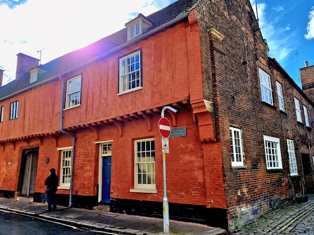
The handsome Grade II listed building is a former merchant's house which was built in the mid-15th century. It was recently converted into a four-bedroom home and is now on the market with Brown & Co at a guide price of £550,000 back in 2020.

It was once home to the famous artist and political activist, Gustav Metzger, who used it as his studio. He was born in Nuremburg in 1926 and came to Britain in 1939 as a refugee. He attended the Royal Academy of Fine Arts in Antwerp between 1948 and 1949 and later lived in London.


At the end of St Nicholas Street is St Nicholas Chapel.

England’s largest surviving parochial chapel, St Nicholas’ Chapel or the Fishermen’s Chapel was founded in 1146 as a chapel of ease to St Margaret’s Church. The roof of this Grade I listed building features a series of beautifully carved angels.
We turn left onto St Ann’s Street and at the end we turn right on to North Street.

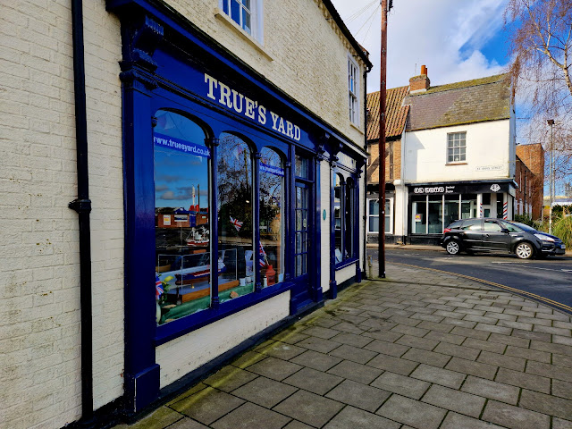
We pass Trues Yard. True’s Yard is virtually all that remains of King’s Lynn’s old fishing community, the North End.

Once hundreds of families lived within a stone’s throw of the beautiful mediaeval chapel of St. Nicholas. The North End had its own boat builders, chandlers, sailmakers, pubs, bakehouses and school.

The hard and sometimes dangerous life they led bred a fierce loyalty in the Northenders – they supported each other in times of crisis, seldom married anyone from outside the North End and cared for their widows and orphans. The menfolk would sail up to 100 miles away to bring in their catch and their women would tend the children, wait, pray and mend the nets when they came home.

The fishing fleet still sails from King’s Lynn, but the old way of life has gone.

There is now a museum here on the bygone fishing life.

At the end we turn right on to John Kennedy Road. We continue down this road (which becomes Railway Road) until we reach the cross road junction with Blackfriars Street and Blackfriars Road.
This is a busy loud road, not the most pleasant of walking.

We cross to the corner of Blackfriars road and follow the path in to The Walks.

We walk down to the fountain and then turn left on to a path that heads back up towards the road. 

This path takes us past St John’s Church and on to St John’s Walk.

When John Motteux, owner of Sandringham, attended a service at St Nicholas’ Chapel in 1843, he was forbidden to sit in any pew because (in those days) these had to be paid for. He therefore offered £1,000 towards building a new church where seats would be free. The building was completed in 1846, paid for by subscriptions, and designed by the architect Anthony Salvin in the Early English style and faced with Yorkshire sandstone. The St John’s congregation are very proud of this heritage and still seek to live out what it means to be ‘the poor man’s church’ today.

After passing the church, bear right off St John’s Walk and follow the path to the Red Mount Chapel.

Red Mount Chapel is an unusual 15th century wayside chapel that was part of the Walsingham pilgrimage route. The chapel was also used by soldiers during the Civil War, who left interesting graffiti in the interior.

Sadly locked up so we couldn't have a look inside.

We walk on through St James Park and pass the old Town Wall ruins and along Broad Walk towards Millfleet.


We cross the busy road pass the library pictured above and down Millfleet.

The walk follows Millfleet back to South Quay and is 2 miles in length. But we aren't ready to finish seeing Kings Lynn yet and we turn off and walk up Tower Place.


We walk on up Tower Place and up to the modern shopping centre.

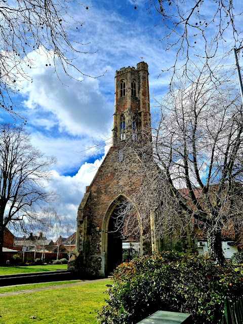
We wander about the town centre before we end up on St James Street and pass the Greyfriars Tower.


The tower, known as Greyfriars Tower survives. It is one of only three surviving Franciscan monastery towers in England and is considered to be the finest.

Following the Dissolution of the Monasteries by Henry VIII, the tower at Lynn remained because it was considered to be a useful seamark by sailors entering the town, still being clearly visible on the town's skyline to this day.

The tower is informally referred to as 'the leaning tower of Lynn' as it leans dramatically to the west. At its worst, the lean was 67.5 centimetres - which given its height of more than 28 metres is just over 1 degree. This compares to 3.98 degrees on the Leaning Tower of Pisa.

Although it is not believed to be in imminent danger of collapse, until recently it did require work to correct the lean to ensure it remains a part of the King's Lynn skyline.

Walking on we reach Kings Lynn Minster, but first we cross the road to look at the Town Hall.

Trinity Guildhall/Town Hall - The guildhall dates to the early 15th century. The building is of brick, but has a magnificent façade of chequered flushwork, with a 17th century porch. Next to the guildhall is the Town Hall, built in 1895 in the Elizabethan and Gothic Revival styles. It also has chequered flushwork to complement the façade of the guildhall. The complex includes a late 18th century courthouse and cell block, as well as a cell block dating from 1937, with many original fittings.

We cross back over to the Kings Lynn Minster church.

The building dates from the 12th to 15th centuries, with major restoration of the nave in the 18th century. Five of its ten bells and its organ also date back to the mid-18th century.

Benedictine priory
The church was established by Herbert de Losinga, Bishop of Norwich in 1095 to serve a Benedictine Priory and dedicated to St Margaret of Antioch. The priory was subordinate to the Priory of the Holy Trinity in Norwich.

The slender 12th-century south-west tower in the Early English Gothic style precedes the larger north-west tower in the Perpendicular style of the 15th century. The chancel with clerestory dates from the 13th century, when the earlier Norman nave was replaced. Elements of the Norman building survive in the base of the south-west tower.


After the English Reformation St Margaret's became the parish church for the town of King's Lynn, and its property was used as an endowment for Norwich Cathedral. Prior Drake was made prebend of the fourth stall in Norwich Cathedral.

The central lantern and south-west spire collapsed in 1741, which destroyed much of the nave. This was reconstructed in a programme of rebuilding between 1745 and 1746 by the architect Matthew Brettingham in an early Gothic revival style. The church retains its medieval misericords.

St Margaret's church was granted the honorary title King's Lynn Minster in 2011 by the Bishop of Norwich.

We leave the church and cross over and walk down St Margaret's Lane and back down to the river.


We follow the route and river back to the car, a lovely walk on a chilly March day!


Monday 20 February 2023

Hadleigh to Kersey,Suffolk circular walk 20th February 2023

GPX File here

On Monday the 20th February 2023, Dan and I set off to walk from Hadleigh to Kersey circular walk in Suffolk.

We drive down Duke Street in Hadleigh and cross the Toppesfield Bridge and park on the right just after by the Riverside Walk. Here is free parking.

Scheduled as an Ancient Monument, this medieval three arch bridge that spans the River Brett, has been described as ‘˜the finest ancient road bridge in Suffolk'.

Toppesfield Bridge

The River Brett has its source is in the villages to the north of Lavenham and it flows through Hadleigh to its confluence with the River Stour via Monks Eleigh, Brent Eleigh and Chelsworth.

We follow the Riverside Walk for a way, a bit too far in fact and we need to double back to take a path that heads out over farmland.

Nice to see all the snowdrops beneath the trees, Spring isn't far away!

We walk across farmland and climb up Broom Hill. I thought Suffolk was supposed to be flat !!

This former quarry is now covered with woodland, grassland and scrub. There are many ancient trees, together with pollarded oaks and small-leaved limes, which had high branches removed, and coppiced hazel and lime trees, which were cut at ground level.

We continue on up Constitution Hill and across Coram Lodge Farm and up to Coram Street.

We follow Coram Street passing Coram Street Farm and take a footpath across the Kersey Vale.


We walk down to the charming home pictured above and the follow Vale Lane.

After walking along Vale Lane for some way, we reach the Church of St Marys at Kersey.


The oldest parts of the church date to the twelfth century. A reconstruction of the church is thought to have started with the north aisle which was joined to the nave by an arcade and completed in 1335. Work then started on the tower, but was delayed by the outbreak of the black death in 1349. The tower was completed in 1481 and the north and south porches were then added.

View down into Kersey.


The church is of flint and stone and stands on high ground to the south of the village. In about 1335 the north aisle was built and the tower's foundations laid. The tower was completed in 1481. The tower has four stages. There are diagonal buttresses, a castellated parapet with flint chequer work and an octagonal stair turret. The south porch has two bays with buttresses rising to crocketed pinnacles. The north porch is similar but less elaborate.

Inside the church, the ceiling has moulded and carved beams and carved panels. The nave roof has hammer beams alternating with tie beams with arched braces meeting in the centre. There are two baptismal fonts, one 12th-century and another 15th-century. There is a 15th-century lectern and chancel screen. The north aisle has a defaced stone carved frieze.

The chancel was rebuilt in 1862 by King's College, Cambridge, and a small vestry was added in the north east corner.


In Medieval times St Mary's was an important site of pilgrimage with a shrine filling the whole north aisle. This survived Henry VIII's dissolution program but was destroyed around the time of the Civil War. On 8 March 2020 the shrine was re-hallowed.

The newly re-hallowed Shrine and church is host to arts and music events. Jazz evenings take place twice a year, classical music concerts, film evenings, dances and various other events happen regularly.

The Shrine was rehallowed in the presence of Leading Aircraftman Dougie Vince. The bomber on which he served as engineer was attacked by an ME 109 as they returned from a raid on western Germany. The navigation instruments were destroyed and a fire started toward the rear of the aircraft. The navigator had no positional fix and fuel was critically low. The RAF, however, had installed two searchlights in the churchyard of St Mary's Kersey which illuminated the church tower, giving pilots a known navigational reference point. As a result, the church gained the nickname of the “Thank God Church”. Mr Vince's bomber fixed their position and landed at a nearby airfield. The tail gunner died in the fire and Leading Aircraftman Vince's hand was almost burnt away as he fought the flames using an extinguisher that had become red hot in the flames.


We leave St Marys and head out towards Kersey.


The main street has a ford across a stream. Its principal claim to fame is that a coarse woollen cloth called Kersey cloth takes its name from it. The cloth was presumably originally made there, but later in many other places too.

The parish contains the village of Kersey and the hamlets of Kersey Tye, Kersey Upland, Wicker Street Green and William's Green.


We walk down the hill into Kersey, quite possibly one of the most prettiest village in Suffolk.

Kersey is famous for its historical medieval timber frame houses which can be seen on the main street running through the village. They are all estimated to date from between the 12th and 15th centuries and are one of the biggest collections preserved in Suffolk and East Anglia.


The main road running through Kersey is called The Street and there’s no doubt that it is absolutely stunning.

The vibrant pink, orange and pastel houses plus the historic timber frames make this a totally unique street to wander up and down.


The village is known for its picturesque main street with medieval timber-framed houses and a ford of a tributary of the River Brett known locally as "The Splash".


Sad to see River House under Scaffolding, ruins the look of the village too. Hopefully its taken down soon.

The Grade II-listed home dating back to 1490 has gone on the market for £1.4million complete with a Tudor tower and Medieval wing in 2022.

River House needs a major overhaul as it hasn't been lived in for more than 20 years and has no central heating.

The home, in the heart of 'Constable country', features a rare wall painting depicting life-size figures in Elizabethan dress.

Its original construction is on a jetted oak timber frame, which is still visible throughout many parts of the house.

In the late 16th and early 17th century, the house was owned by the Cooke family, wealthy clothiers.


The 13th century picturesque pub, called The Bell Inn, on the main street cannot be missed for its timber framed medieval facade.

This is such a well-kept pub, both inside and out and it also boasts a great beer garden if you’re visiting in summer and want to enjoy the quiet village atmosphere with your drink.

Sadly closed as it was still too early in the day!


We walk up the hill and pass the water pump here in Kersey.


We follow the road round and do some more road walking for a while.

Further up the road we take a footpath on our right and follow the field round and we cross the road into Kersey Mill.

The Mill building, Maltings and elegant Georgian fronted Mill House are surrounded by 18 acres of grounds, beautiful established water gardens and sunken Mediterranean garden, with brooks and streams that flow to the River Brett.

Kersey Mill is complimented with a host of diverse local businesses, which are independently owned. These range from a gym, pilates room, art studio with crafts and gallery, florist, beauty salon, boutique, suffolk craft and produce and cake shop . In addition there are services providing holistic and wellbeing therapies, counselling, creative photography and graphic design and promotion.

You will also find a unique wedding and corporate meeting venue nestled in the grounds. While you are visiting us, why not take the opportunity to relax and unwind in the coffee shop.


We stop in the coffee shop, Dan had a hot chocolate and myself a pot of tea. We had a look at the menu but at  £9.80 for a sausage roll and the same price for a sandwich, err no thanks!


We leave the coffee shop and pass the wedding venue, and stopped to have a go on the swing!

We cross the ditch and over the fence to avoid the long walk around up the access road.

We take the same footpath we walked up but turn left across a bridge and across farmland and out onto Mill Lane.

Almost immediately take a footpath opposite and across more farmland.

St Marys is still in sight and has been pretty much since we left it.

We walk pass Noaks Tye Farm and its dilapidated farm buildings and then down down a tree lined path and more snowdrops.


We follow the path uphill across farmland that's full of startled partridges taking flight.

We cross the busy A1071 and onto the path opposite.

We cross the fields that now leads us back into Hadleigh.

We head back downhill into Hadleigh.


We pass The White Hart.

The White Hart is a substantial detached house which according to its Grade II listing dates from the 15th Century. As the name suggests it served the town as a public house, however, following a successful planning application a change of use to residential was granted in December 2018. Up for sale at £775,000!

We walk on crossing the River Brett and onto Hadleigh's High Street.

Established in 1991, Ainger Holbrows Ltd are a family-run business selling new and used cars for over 25 years. Pretty certain these Austin's are for sale though!


The former Kings Arms on Benton Street is a typical example of timber framing. The building, a pub for over 400 years, has sections that date to the 15th century. It was known unofficially as the "Old Monkey" and is still referred to by that name today. It is now a private residence and bed and breakfast.

We walk up along High Street, it has a nice feeling to this quaint town. I like it!

We stop to shop at Adnams shop and stock up on beers to take home!


The first documented lord of the manor was ealdorman Byrhtnoth, who was killed at the Battle of Maldon in 991, when Anglo-Saxon forces tried to repel Viking invaders. Ealdorman was the highest rank of noble and just before his death he was the most senior ealdorman in the country to King Æthelred I. Byrhtnoth and his wife had no children, and "so he bequeathed his many lands to churches or religious institutions around the country". Hadleigh received its market charter in 1252 and had a grammar school by 1275. The manor of Hadleigh, along with those of Lawling in Essex and Monks Eleigh in Suffolk, were among those given to the Priory Church of Canterbury Cathedral. It made Hadleigh an "archiepiscopal peculiar" – under the direct control of the Archbishop of Canterbury.


Hadleigh was one of the East Anglian towns that derived its prosperity from its wool and cloth industries. It has a 15th-century timber-framed Guildhall and many fine examples of timber and brick listed buildings, some with highly detailed 17th century plasterwork or "pargeting". Most of these buildings can be found in the High Street, Angel Street, Benton Street and George Street.

A old milestone stands on the High Street that once had a unique lamp standard but now removed.

We turn down Church Street and up to St Marys in Hadleigh.


The church has a late 13th-century or early 14th-century tower and 14th-century aisles. The church was almost wholly reworked in the 15th century, when the arcades were rebuilt, and the clerestory, south porch and northeast vestry added. At this time also the whole building, except for the tower, was re-fenestrated. In the 19th century and early 20th century the church was extensively restored.

The church is constructed of flint rubble with stone dressings and has leaded roofs and spire. It has an aisled nave and chancel, a western tower, a two-storey south porch and a north vestry. On 26 April 1950 the church was designated a Grade I listed building. Its listing by Historic England records the principal reasons for designation as its size, the quality of its late-medieval architecture and its interior.

Opposite the church is Hadleigh Town Hall & Guildhall Complex. It is one of the finest medieval buildings in East Anglia and the only one available for hire in our beautiful market town that can trace its origins back to the 15th Century.


The Market House

The Guildhall buildings are, in fact, formed of three separate structures, all of which lie to the south of the churchyard: the Market House, the Guilds Halls and the New Town Hall (Grand Hall). They are located on land that belonged originally to the manor of Toppesfield Hall. In 1252, king Henry III of England granted a weekly market and an annual fair to Gilbert de Kirkeby, his wife Lauretta and their heirs. By 1438, the Lord of the Manor was William de Clopton, who granted these rights, to fifteen trustees, with an initial annual payment of 6s 8d. In 1438, the Hadleigh Market Feoffment was formed, to manage the market and buildings. The oldest part of the complex, the Market House, fronts the churchyard. Later the Guilds Halls were built and the final addition was the New Town Hall. Abutting the Market House to the west was the 'Long Hall newly built' (1438), which appears to have been the home of the Grammar School, the earliest record of which is dated 7 May 1382. Its last use was as an almshouses and accommodation for the Dean's servants; but it was seriously damaged in a storm in 1884 and was demolished.


The Deanery.

The Deanery, is a most impressive ecclesiastical property believed to date from the early 14th Century, of impressive proportions and standing within the grounds of St Marys’ Church. Now a private residence.


Guthrum, King of the Danes, is said to be buried in the grounds of St Mary's Church in the town. He was defeated by King Alfred at the battle of Edington in 878.


We leave St Marys and walk across to Market House.


We walk through to Market Place and pass the new town hall.

The New Town Hall.


At the top of Market Place on the High Street is the White Lion Hotel.

A former Commercial Inn & Posting House.

Now converted into a number of flats. The building retains many original features both at the front and in a small enclosed central courtyard. Sadly a fire in 2011 damaged part of building to the rear of the property.


We walk back down Market Place passing a old water pump. We walk through onto Duke Street and back to Toppesfield Bridge.

Dan stops to feed the geese from the bridge.


We are now back at the car after a 7.8 mile walk in spring like weather,  A great day!

Now for the drive home!