Tuesday 4 July 2023

Trencrom Hill,Lelant Downs Cornwall 3rd July 23

GPX File Here.

On Monday the 3rd July 2023, I decided to drive a short distance from the St Ives Holiday Village run by John Fowler to the Trencrom Hill car park (TR27 6NP) to climb Trencrom Hill.

It was late evening so the sun was much cooler and was beginning to set, giving the area a nice glow.

Trencrom Hill (or Trecrobben) is a prominent hill fort, owned by the National Trust, near Lelant, Cornwall. It is crowned by an univallate Neolithic tor enclosure and was re-used as a hillfort in the Iron Age. Cairns or hut circles can be seen in the level area enclosed by the stone and earth banks. The hill overlooks the Hayle Estuary and river, and Mount's Bay and St Michael's Mount can be seen to the south. The hill was recorded as Torcrobm in 1758 which is derived from Cornish "torr crobm", i.e. 'hunched bulge'.


Trencrom Hill was acquired by the National Trust as freehold on 8 August 1946 from Lieutenant Colonel G L Tyringham. The freehold was 25.568 hectares (63.18 acres). On ascending the hill from the north side there is a plaque in situ in the rock facing the path. It reads:

"This property was presented to the National Trust by Lt Col C L Tyringham, of Trevethoe in March 1946 & at his wish is to be regarded as a memorial to the men and women of Cornwall, who gave their lives in the service of their country during the two world wars. 1914 – 1918, 1939 – 1945".

The well on the west side of the ramparts of the hill fort is known as the Giant's Well. James Halliwell-Phillipps mentioned it in 1861 in Rambles in Western Cornwall, "Outside the vallum at Trecrobben, or, as it is called by the rustics, Trancrom, is the Giant's Well". The well low down on the eastern flank of the hill is not the Giant's Well and is a disused shaft of the Praed Consols (Wheal Cherry/New Trencrom) sett, which was used as a well after the mine had flooded.

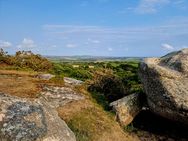
The hill began to rise a little more steeply towards the top and a little scramble up a coupe of high rocks.


The sett (area) of Wheal Cherry (later known as New Trencrom Mine and Mount Lane Mine) included the summit of Trencrom Hill. Trencrom is within the granite and the sett also covered the metamorphosed killas to the east. Wheal Cherry seems to have been short-lived with £2,293 spent on the erection of a 24-inch pumping engine and 24 inch whim with stamps in 1857/58 and by September 1858 the sett and materials being offered for sale. The sale notice stated that Wheal Cherry was ″a valuable property″. There was another attempt at the start of the 20th century by the Gerry Brothers of Lelant and after five years they sold their interest in 1907. At this time a new shaft was being sunk on the eastern slope and at a depth of 7 fathoms (42 ft; 13 m) found a 2 feet (0.61 m) wide lode which yielded 60 pounds (27 kg) of black tin to the ton. Work was still continuing on Wheal Cherry in 1916. A further attempt in 1943 at the mine, now known as the Mount Lane Mine was unsuccessful.

A survey in January 1996 found small scale quarrying, mostly post-medieval using drills but in some cases using wedges which may be earlier. Large parts of the granite summit have been levelled and a paved track was probably used to transport stone from the quarry face on carts.


I reach the top (175m) with views across to Carbis Bay.

Trecobben, the giant of Trencrom, was supposed to have killed Cormelian (wife of Cormoran) by throwing a hammer across to St Michael's Mount.

In several parts of Cornwall there are evidences that these Titans were a sportive race. Huge rocks are preserved to shew where they played at trap-ball, at hurling, and other athletic games. The giants of Trecrobben and St Michael’s Mount often met for a game at bob-buttons. The Mount was the “ bob,” on which flat masses of granite were placed to serve as buttons, and Trecrobben hill was the “mit,” or the spot from which the throw was made. This order was sometimes reversed. On the outside of St Michael’s Mount, many a granite slab which had been knocked off the “ bob ” is yet to be found; and numerous piles of rough cubical masses of the same rock, said to be the granite of Trecrobben Hill,* shew how eagerly the game was played.

Trecrobben Hill was well chosen by the giants as the site of their castle. From it they surveyed the country on every side; and friend or enemy was seen at a considerable distance, as he approached the guarded spot. It is as clear as tradition can make it, that Trecrobben was the centre of a region full of giants.

View across to St Michaels Mount

St Michael's Mount may have been the site of a monastery from the 8th to the early 11th centuries. Edward the Confessor gave the site to the Benedictine order of Mont-Saint-Michel and it was a priory of that abbey until the dissolution of the alien houses as a side-effect of the war in France by Henry V. Subsequently, it ceased to be a priory, but was reduced to being a secular chapel which was given to the Abbess and Convent of Syon at Isleworth, Middlesex, in 1424.Thus ended its association with Mont-Saint-Michel, and any connection with Looe Island (dedicated to the Archangel Michael). It was a destination for pilgrims, whose devotions were encouraged by an indulgence granted by Pope Gregory in the 11th century. The earliest buildings on the summit, including a castle, date to the 12th century.


There are views stretching across North Cornwall to Godrevy and towards Rosewall Hill to the west.

More Folklore,

THE SPRIGGANS OF TRENCROM HILL.

IT is not many years since a man, who thought he was fully informed as to the spot in which a crock of the giant's gold was buried, proceeded on one fine moonlight night to this enchanted hill, and with spade and pick commenced his search. He proceeded for some time without interruption, and it became evident to him that the treasure was not far off. The sky was rapidly covered with the darkest clouds, shutting out the brilliant light o the moon--which had previously gemmed each cairn--and leaving the gold-seeker in total and unearthly darkness. The wind rose, and roared terrifically amidst the rocks; but this was soon drowned amidst the fearful crashes of thunder, which followed in quick succession the flashes of lightning. By its light the man perceived that the spriggans were coming out in swarms from all the rocks. They were in countless numbers; and although they were small at first, they rapidly increased in size, until eventually they assumed an almost giant form, looking all the while, as he afterwards said, "as ugly as if they would eat him." How this poor man escaped is unknown, but he is said to have been so frightened that he took to his bed, and was not able to work for a long time.

Keep an eye out for holes in the summit's boulders. These were drilled by miners during the Victorian times and on Midsummer's Day the merrymakers would fill the holes with gunpowder and light the fuses in celebration.


"On the largest of these cairns are some rock-basins, known respectively as the Giant's Chair, the Giant's Cradle, and the Giant's Spoon.


I descend back down to the bottom and the car.

Only a short walk but a great hill at sunset. I walked this again later ion the week with my kids. We walked from St Ives Holiday Village up a very busy road (Not advisable) and then after maybe a mile we took a footpath on our left and this immediately begins to climb steeply. We reach another road which we cross and walk up the path to the summit. We decide to descend the hill on the side of my previous trip and down to the car park and follow this quiet road back to the site.

Tuesday 13 June 2023

Norfolk Coast Path Day 2: Burnham Deepdale to Stiffkey 13th June 2023

GPX file here

On the 13th June 2023 Ian and I left home at 0600 hours and drove up to Burnham Deepdale to continue our Norfolk Coast Path Journey. We parked up at the same spot as before in the layby by the church and we walked back down The Drove and back onto the Coast Path, as we do a Red Kite soars above.

We pass the houseboat in front of us turning right and follow the marshland again.

The path now follows a raised bank with marshland on both side this passes the Burnham Deepdale Sluice and the Mow Creek, this seems to stretch on for ever.

It’s already hot but it is nice to have the sea breeze. Oystercatchers cry out in the water and skylarks rise up from the grass with their ascending beautiful song.

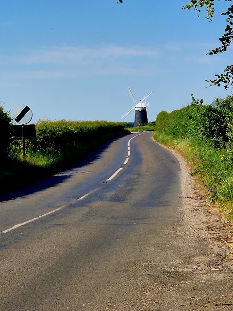
The Burnham Overy Staithe Windmill looms in the distance but is a long way off yet.

The raised bank winds round a loop and now heads inland and we pass the River Burn on our left. This creek winds off with boats moored with views over to Burnham Overy Staithe.

But first we have to follow the path as it winds it way from the town and along a creek.


We cross the creek and walk towards the Windmill again as we approach Burnham Overy Staithe.

All the fields in the local area are filled with lovely poppies.

We reach the Windmill now.
 
Burnham Overy Staithe Mill was built in 1816 for Edmund Savory, a miller who was running a watermill on the River Burn known as the Lower Mill. Savory worked the mill until his death on 9 February 1827, when it passed to his son John.

John Savory worked the mill until his death on 27 September 1863, and the mill passed to his son, also named John. In 1869, a law was passed that all trade horses should be licensed. John Savory was convicted in 1870 and fined £5 for having one more horse than he held a licence for. He was again convicted in 1873 and fined £5 for the same offence. The mill was offered for sale by auction on 23 June 1888 at the Norfolk Hotel, Norwich. The premises comprising a steam mill powered by a 16 horsepower (12 kW) steam engine driving four pairs of millstones, the watermill driving three pairs of millstones and the windmill, also driving three pairs of millstones. As well as the mills there was a 25-coomb maltings, granaries and various other farm buildings, together with over 40 acres (16 ha) of land. The lot was unsold, and Savory worked the mill until 1900 when it was sold to Sidney Dewing. In 1910, the mill was sold to Sidney Everett, a maltster of Wells-next-the-Sea. In 1914, the mill was tailwinded. It was last worked in 1919. In 1926, the mill was sold to Hugh Hughes, an architect from Grantchester, Cambridgeshire. Hughes had the mill, which had been stripped of machinery by this time, converted to holiday accommodation owned by the National Trust.


We walk down Tower Road into Burnham Overy Staithe.

The villages name means 'Homestead/village on the River Burn' or perhaps, 'hemmed-in land on the River Burn'. 'Overy', meaning 'Over the river', was added to distinguish it from the other Burnhams in Norfolk.

Between Burnham Overy Staithe and the sea, the river spreads out into multiple tidal creeks through the salt marshes that fringe this stretch of coast, and finally reaches the sea by passing through the fronting sand dunes at a gap near Gun Hill locally known as Burnham Harbour. Small boats can reach Burnham OveryStaithe through this gap and creek. Today Burnham Overy Staithe, and the associated harbour, is a recreational sailing centre. It is also the point of departure for seasonal ferries to the Scolt Head Island National Nature Reserve.

Historically Burnham Overy was the port for the surrounding villages of the Burnhams. Both settlements lie on the River Burn, and until the end of the Middle Ages trading ships were able to reach the village (now Burnham Overy Town). With the silting of the river, commercial traffic switched to the downstream Staithe. With the coming of the railway to the Burnhams in 1866, commercial shipping declined and the last cargo is believed to have been shipped from the Staithe soon after the end of the First World War.


Burnham Thorpe, the birthplace of Horatio, Admiral Lord Nelson, lies 1 mile (1.6 km) to the south-east. According to various letters and documents, Nelson learned to row and sail a dinghy at Burnham Overy Staithe, at the age of 10, two years before joining the Navy. The village’s only pub is called “The Hero” in his honour.

It was shortly after the Hero pub where we should have continued onto the Coast Path, but we missed this and we walk on down the A149. We pass the turning for Gun Farm and further down we join a path that leads us down through the Holkham Nature Reserve and eventually back onto the path alongside the River Burn.

Looking back we hadn’t miss much at all, neither of us saw an acorn sign to point us in the right direction.

We stop on the bench for a drink and some food before we walk on.

We follow another raised bank for a while until we follow the path over the sand dunes and onto the Holkham Beach.


The path follows its way through the dunes, but it is easier going out on the beach on the firm sand the tide has left behind as it is still a very long way out.


One of the great sights to come and watch on this beach in July is the Household Cavalry.

They come here annually, bringing their horses to exercise them on the beach. It is a wonderful sight if you manage to time it right, usually at the beginning of July.

The Household Cavalry have been coming to Norfolk for more than 23 years now for their annual training. As operational soldiers, they are based in London for 11 months of the year and their trip up to Norfolk allows them a little bit of relief from their full-on schedules. These are the soldiers who play a large part in ceremonial duties in London as well as serving abroad.

It's fun to watch some of the horses who haven't been in the sea before and the skilled horsemanship of the soldiers riding bareback when they go into the water.


After a long way along the beach, the sand becomes soft and its now hard going under foot, we pass through the Holkham Nudist beach. Where Ian says “Just my luck, just a naked man to look at!”


I have a chuckle then suggest we make our way over to the Pine Forest called Holkham Meals where I hope the ground will be firmer.


We lose the path again due to poor signage but we trek from our path through the trees and emerge back onto the Coast Path be it a lot further away from the coast than we were.


Ian emerging from the trees, back on the path now!

We stop on a bench for more water before following the path through the blazing heat.

We walk pass Abrahams Bosom Lake and into a Car Park and out to the Wells-Next-The-Sea Café.


Out onto the path we turn left to see the RNLI lifeboat Station and the Coastguard Lookout with views over the beach.

There has been a lifeboat at Wells for over a hundred and fifty years; the first RNLI lifeboat was stationed here in 1869. Its greatest test was in 1880, when it was launched to help the several vessels including the Ocean Queen. The conditions were appalling, and 11 of the 13 crew lost their lives after being hit by a huge wave. A memorial can be found by the Harbour Offices.


We turn back and walk along the path into Wells-Next-The-Sea.


We pass a harbour with its many boats.

We follow the bank alongside East Fleet into Wells.


The Harbour is on the North Norfolk Coast. It is used by a small fishing fleet and by visiting commercial and fishing vessels, including vessels engaged in surveys, crew transfer or safety boat operations. The harbour also caters for a growing number of leisure craft which are both local boats and an increasing amount of visiting craft.

There has been a port at Wells for over 600 years. The harbour is protected by salt marshes behind a sand bar. Because it is a natural safe haven from the unpredictable North Sea weather the Port of Wells was one of England's major harbours in Tudor times and a thriving, centre for shipping and maritime industry in the 18th and 19th centuries. Its greatest period of prosperity was probably from 1830 to 1860. The stone quay side was constructed in 1845 following an Act of Parliament the previous year. The coming of the railway in 1857 marked the beginning of decline though there was a resurgence from 1960 to 1989 when coasters bringing fertilizer and animal feed came in some numbers. The Granary with its distinctive gantry was built around 1904; it has now been turned into apartments. The gantry allowed grain to be transferred between the building and ships without disrupting road traffic. The railway closed in 1964 and in 1976, the Wells Harbour Railway was constructed to link the town with the beach and Pinewoods Holiday Park. It replaced a withdrawn bus service.

Mentioned in Domesday Book, the town derives its name from the many clear spring wells, at one time over 180 of them, in the town. Early on it became both a fishing port, sending its small ships as far as Iceland, and a supplier of grain to London as long ago as the 1300s. It was a major importer of coal in the 1500s supplying the miners of the north east in return with wheat for their bread and malt for their beer.

One reason why it is has preserved its character is that it was until recent times a manufacturing town, once supplying huge quantities of malt to the Dutch and then latterly to London breweries. It was, in the eighteenth century, nationally important as a producer of malt. The iconic maltings and granaries, now turned to new uses make its working quay a fascinating place to visit. An impressive feature of the harbour is the large granary building with its distinctive overhanging gantry. Built in 1903, the granary has now been turned into luxury flats with magnificent views of the harbour.

As a commercial port, Wells’ high point was in the 19th century when large wooden sailing vessels, some over 300 tons were built here, some 170 or so of them. It was then that the stone quay was built. There were two shipyards in Wells, situated in the East End (where now only house names give away their location). Shipwrights were supplied with locally made ropes, spars, sails and iron work made by local blacksmiths. It was the arrival of the railway in 1857 that marked the beginning of the decline in the sea-going trade of Wells, though those who came to Wells fifty years ago would have seen a huge if short lived revival of commercial shipping.


As many as eight cargo vessels, double banked would have been seen at the quayside in the 1970s and 80s having brought fertiliser and animal feed from abroad. Eventually vessels became too large to be accommodated and latterly only the Dutch sailing barge the Albatros continued the trade.

Into the town from the quay, is the charming Staithe Street with its traditional shops, part of a delightful network of narrow streets, old alleys and yards. Some of the buildings in the town are hundreds of years old, including former coaching inns and public houses. Many are now listed buildings. At the top of the town, lies the Buttlands, a wide green space, fringed by lovely lime trees and surrounded by some impressive Georgian and Victorian houses.


I buy some Chips and a drink from Frenchs and we sit on the front with the masses of other day-trippers doing the same.


We have a quick look up Staithe Street and its shops before we continue on the path along East Quay.


Why don't these companies think about the sign writing when the van doors are open Ha ha.


We walk on through a small industrial estate with ship repairs etc.


After a while we are walking through Grassland with marsh to our left.

This path seems to go on forever, I just wanted to make it to Stiffkey now and get the bus back to the car.

After much much walking we walk into Stiffkey's Saltmarshes car park and up Green Way.


At the top we walk out onto Wells Road and to the bus stop, where we catch the CH1 Coasthopper to Wells.

At Wells we cross the road and as luck would have it straight onto the next bus the 36 Coastliner back to Burnham Deepdale.

A great but tiring walk, into the car for the long drive home!