Wednesday 9 February 2022

Benfleet to Leigh On Sea, Essex Walk 9th February 2022

OutdoorActive file here

GPX File here

I leave home and take the train to Benfleet Station on the C2C Fenchurch Street Line.

I leave the station and walk up the road and then along the Benfleet Creek and the Benfleet Marina.


1969 Morris Minor

A 1951 Dodge 

I walk on following the creek, all the noise, noise of hustle and bustle is left behind, pure silence here.


I now take the path through the gate and over the Fenchurch Street line.


Up ahead I can see Hadleigh Castle, and it is this that I am heading for next.

Now I turn left and up a steep hill to reach the Castle.

It was a steep hill that raises your heartbeat, but the views are so worth the effort!

Hadleigh Castle is a ruined fortification in the English county of Essex, overlooking the Thames Estuary from south of the town of Hadleigh. Built after 1215 during the reign of Henry III by Hubert de Burgh, the castle was surrounded by parkland and had an important economic and defensive role. The castle was significantly expanded and remodelled by Edward III, who turned it into a grander property, designed to defend against a potential French attack, as well as to provide the King with a convenient private residence close to London. Built on a soft hill of London clay, the castle has often been subject to subsidence; this, combined with the sale of its stonework in the 16th century, has led to it now being ruined.

Hadleigh Castle was first built by Hubert de Burgh, the 1st Earl of Kent, who was a key supporter of King John. De Burgh was given the honour of Rayleigh by John in 1215 as a reward for his services, but chose not to develop the existing caput of Rayleigh Castle, instead building a new fortification south of the town of Hadleigh. The exact date of construction is uncertain, but it is now believed the work was conducted early in de Burgh's tenure of the site, permission being retrospectively officially confirmed through a licence to crenellate in 1230 under Henry III.

De Burgh finally fell out of favour with Henry III; he was imprisoned and then finally stripped of Hadleigh Castle in 1239. For the rest of the century, Hadleigh was retained as a royal castle, as part of an estate containing 142 acres of agricultural land, the park and the castle mill. By the 1250s, the castle had fallen into neglect and, despite some investment after it was given to Queen Eleanor in 1273, it remained in relatively poor condition. Only the mill, vital for the operation of the wider estate, appears to have been well-maintained. A new 17-metre-wide by 9-metre-long (56 foot by 30 foot) hall and an adjacent solar complex were built at the castle around 1290, but collapsed due to subsidence shortly afterwards. In 1299 the castle was given to Queen Margaret, who complained about the quality of the building and insisted that repairs were carried out. Her husband, Edward I, visited the castle twice, using it as a base for hunting in the area.

Edward II took a much closer interest in Hadleigh, leading to a period of renewal and rebuilding during his reign and that of his son, Edward III. Edward II first stayed there in 1311, and work was done to renovate the castle before he arrived, including building new royal quarters and repairing some of the castle walls that had succumbed to subsidence. Amongst the buildings known to be in the castle during the period were the castle hall, larder, kitchen, cellar, a long house, prison, an "old chamber" and armoury; they were guarded by a garrison of 24 soldiers during crises. Edward stayed there frequently during his reign up until 1324, on occasion travelling to Hadleigh Castle from London on his royal barge, which docked at a wharf to the south of the castle.

Edward III acquired Hadleigh Castle in 1330, when he recovered it from his mother, Isabella of France, who had taken it from Edward when she deposed him in 1326. Edward paid little initial interest to the castle, but in the 1360s decided to make much greater use of the property, ordering large parts of it to be rebuilt at a cost of more than £2200. Between 1361 and 1363 the internal buildings were renovated and new royal lodgings built along the south walls, after which the east side of the castle was rebuilt entirely, with two large circular towers installed in a new stretch of curtain wall, completed by 1365. The north side of the castle was rebuilt to include a main entrance with a portcullis and a drawbridge, protected by a barbican and a large circular tower called the "High Tower", which was complete by 1370. The work was probably overseen by William of Wykeham.

Originally, historians believed that Edward's decision to rebuild much of the castle was in response to the growing tensions with France; in this version of events, Hadleigh would have formed an importance coastal fortification along the Thames estuary, protecting it from French raids. Current historical opinion plays down this motivation, noting that at the time of the work on Hadleigh relations with France were unusually good. Instead, it is suspected that the increasing elderly Edward intended Hadleigh more as a personal retreat close to London, where he could stay in privacy and considerable comfort. Whilst the entrance on the inland side remained relatively basic, the building work created a grander impression from the estuary – any visitors to London, English or French, would have passed by Queenborough Castle on the south bank and Hadleigh on the north, the combination communicating a strong sense of royal power.

Edward III's grandson, Richard II, made little use of Hadleigh, and the use of the castle was granted to Aubrey de Vere until his death in 1400. The castle was passed amongst a number of high-status owners during the 15th century, but saw little use by the crown. Edmund of Langley and his son Edward of Norwich, the Dukes of York, used the castle in the early years, before passing it on to Humphrey of Lancaster, the Duke of Gloucester. Richard, Duke of York, used the castle next, before it passed to Edmund Tudor in the middle of the century. The tradition of the castle forming part of the queen's property was then reinstated and it was granted to Elizabeth Woodville, the wife of Edward IV. Henry VIII made no known use of the castle himself, but it formed part of the dower of three of his wives - Catherine of Aragon, Anne of Cleves, and Catherine Parr - and the castle's parks were used as sources of timbers for his navy.

After 1544 the estate began to be broken up; first the parks were sold and then the castle itself, bought by Lord Richard Richfrom Edward VI for £700 in 1551. Rich dismantled the castle for the value of its stone, primarily between 1551 and 1575, and the castle, now thoroughly ruined, passed through Rich's descendants.

The English painter John Constable visited Hadleigh in 1814 and made a drawing of the castle as preparation for ten oil sketches and a single painting. The oil painting Hadleigh Castle was produced in 1829 and exhibited at the Royal Academy in the same year. One of the sketches is currently displayed at the Tate Gallery, London, while the painting now hangs in the Yale Center for British Art at New Haven, United States. Constable's painting, "one of his most monumental works" according to the art historians Tammis Groft and Mary Mackay, depicts the early 19th-century Hadleigh Castle as a decaying, man-made structure, succumbing to the elemental power of nature.

William Booth purchased Hadleigh Castle and its surrounding site in 1891 for the use of the Salvation Army, which established a farm to train the English poor prior to them being sent overseas to the British colonies. Considerable subsidence and slippage on the ridge occurred between 1898 and 1923, causing a collapse of the southern curtain wall.

The Salvation Army gave the castle to the Ministry of Works in 1948, and it is now owned by English Heritage, classed as a scheduled monument and a Grade I listed building. Subsidence and landslips have continued; the north-east tower largely collapsed in the 1950s, and further major slippages occurred in 1969, 1970, and 2002. One of the three-storey towers at the eastern side stands to nearly full height with narrow rectangular windows in the upper levels. The second tower has only about one-third of its original form. Some sections of the curtain wall have survived, as well as the foundations of the great hall, solars, and the kitchen.

The castle is still surrounded by the 19th-century Salvation Army farm, and beyond that by Hadleigh Country Park, owned and managed by Essex County Council and a Site of Special Scientific Interest with special regard for invertebrates.

I leave the castle behind and head off towards Leigh on Sea.

I pass Leigh on Sea Railway Station and take a road that will lead me into Old Leigh.


In the 11th century Leigh was a marginal community of homesteads. The Domesday Book records 'five smallholders above the water who do not hold land', who were probably engaged in fishing thus giving Leigh a claim to nearly a thousand years of activity in the fishing industry.

The main seafood catch from Leigh fishing boats has always been shellfish and whitebait. Many of the local trawlers were at one time bawleys, and two of Old Leigh's pubs – the Peter Boat and Ye Olde Smack – owe their names to types of local fishing boat. Local fish merchants land, process and trade a wide range of supplies daily, including shrimps, lobster, crab, seabass, haddock, cod and mackerel, cockles, whelks, mussels and oysters.


The riverside settlement of 'Old Leigh', or 'The Old Town', is historically significant; it was once on the primary shipping route to London. From the Middle Ages until the turn of the 20th century, Old Leigh hosted the settlement's market square, and high street (known as Leigh Strand). Leigh had grown to become a prosperous port by the 16th century; ships as large as 340 tons were built here for fishing and other purposes. Elizabethan historian William Camden (1551-1623) described Leigh as "a proper fine little towne and verie full of stout and adventurous sailers". By the 1740s however, Leigh's deep water access had become silted up (as attested to by John Wesley) and the village was in decline as an anchorage and port of call.

With the advent of the railway line from London to Southend during the mid-19th century, much of the "old town" was demolished to accommodate its passage, and new housing and streets began to be built on the ridge of hills above the settlement.

I enter Old Leigh, been here many times before but you never tire of the place!


My first stop is The Crooked Billet, first time in this pub. Quite a pleasant pub too! I had a nice Nicholson Pale Ale from the Cornish St Austell Brewery.

Next I went across the road for my old Leigh tradition of seafood from Osborne Bros.

As I walk on further I pass the site of an old spring hidden behind a wall and metal bars.


Natural springs are common in parts of Essex and were originally the only source of fresh water for some settlements. In Leigh-on-Sea High Street is an early nineteenth century brick structure at the bottom of a conduit carrying water from a cliff top spring. A cast iron plaque dated 1846 records the reinstatement of the well head in 1825.

The spring no doubt issued from the junction of the Thames terrace gravels with the underlying London Clay. A stone in Rectory Grove, not now in its original position, was placed at the well head in 1712.


Next I popped into The Peterboat Pub , one I have been into before. But not today its closed for refurbishment and closed till the weekend.

Across the road is The Hatch where you can buy coffee and snacks, I wasn't interested in any of those but the old 1930's Southend Pier Train Carriage in there grabbed my eye. 


I walk on and find the Leigh Heritage centre, I don't remember having ever see this before. Its free entry and I popped in for a quick look about.

The Heritage Centre stands in the Centre of the Old Town in the old Smithy. Along with many other buildings in the Old Town the Smithy was purchased by the Borough Council many years ago with a view to a development which never took place and it was allowed to fall into disrepair until the Leigh Society formed and decided to rescue the building.

Over the centuries the building had been owned by several people and used for a variety of uses.


I walk on and pop into The Olde Smack , another pub I have never been in.

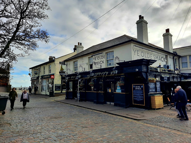
On entering I notice it is a Greene King pub, I order a pint of Ye Olde Smack Bitter. Not impressed but then I never am with any Greene King beer.
 

I leave the pub and walk up get a small portion of chips to eat by the small beach here.


I cross over the railway and up the road before walking up the steep Church Hill.


Up at the top of the hill is church of St Clements.

It's well documented that Leigh has a mention in the Domesday Book, and for good reason. From ancient times to now Saint Clement’s has been at the heart of Leigh, a thriving fishing community and the last port stop before London.

The Patron Saint, Saint Clement, was Pope and Martyr. He was a Roman citizen of noble birth, baptised by Saint Peter in Jerusalem. For his faith in Jesus Christ Saint Clement was bound to a heavy anchor and thrown into the sea. Saint Clement is one of the patron saints of fishermen, so it is appropriate that he is the Patron Saint of Leigh, with the town’s long seafaring tradition and cockling industry.

Of the current church the oldest part of the building is the present north aisle, dating from c.1400. Legend has it that the stones the church is built from were taken from the ruins of Hadleigh Castle, although this is wholly apocryphal. Into the north wall are set some stone steps leading up to the long since removed Rood Screen. The ceiling of the north aisle resembles the inverted hull of a ship, and it is thought that it may have been constructed by the boat builders of medieval Leigh. Much has been added to the church building over the centuries, as the town and population of Leigh grew, as chronicled in Bundock’s book.

I stop off in Elm Road to visit Hopsters and buy a bottle of Delirium Red, delicious it was too!

I leave and walk back downhill towards Leigh On Sea railway station.

A 1971 Triumph TR6.

I reach the station after a 6.1 mile walk.


Monday 17 January 2022

Hackney Wick , London Circular Walk 17th January 2022

GPX File here

VIewranger File Here.

On Monday the 17th January 2022 I got the train to Hackney Wick Station for my first walk of the year. I decided to do a city walk as I couldn't face another mud fest like the walk before and rather than chance it I'd do this walk, besides there's three breweries here. Only two open during the week though Old Street Brewery is Weekends only.

From the Station I walk into Queens Yard where the three breweries are; not open yet they can wait for the end of the walk.

Howling Hops Brewery

Crate Brewery

The White Building is home to Crate Brewery and centre for art, technology and Sustainability but was once an old prints works.

I cross a bridge over the River Lee Navigation and follow this along its towpath.

The Lee Navigation is a canalised river incorporating the River Lea (also called the River Lee along the sections that are navigable). It flows from Hertford Castle Weir to the River Thames at Bow Creek; its first lock is Hertford Lock and its last Bow Locks.

A Coot taking a rest on a boat.

It has a long association with navigation, as the marshes of Walthamstow have produced a dugout canoe from the Bronze Age and parts of a Saxon barge. According to the Anglo-Saxon Chronicle, the river was used by Viking raiders, and King Alfred changed the level of the river to strand Guthrum and his fleet. In more peaceful times, it became important for the transport of grain from Hertfordshire, but navigation of its southernmost tidal reaches of Bow Creek were difficult due to its tortuous meanders.


Rescued from the scrap yard in the 1970’s her current owner, a shipwright, currently working on the rebuild of the Golden Hinde, has been slowly restoring her and returning her to sail as she was laid up for about 20 years with little working having been done to her.

‘Gebroeders’ previous owners had had the old bottom cut out and new floor frames and bottom plate put in her in the late 90s and for a time she was in France before being bought to the UK, where she now has a mooring on the River Lea, cruising the Thames and Medway.

The Owner is hoping to attend the next ‘sail Amsterdam’ and compete in the Swale and Whitstable Harbour Match in 2021.

The barge was built in 1879 by J.F. Meursing in Amsterdam (registration number; Amsterdam-1052) for Widow Cleijndert, a Grain merchant in Nieuwendam in South Friesland. In The Meursing Yard archives, held in the museum, is a wooden half model of the boat.


 I stop under a bridge and check how far I'd gone. A check reveals I'm on the wrong part of the canal, so I turn around and walk back. Lucky I'd not walked too far. I was so confident I knew where to go without consulting maps!

Back at The White Building I climb the steps cross Carpenters Road and back down steps on the other side of the Lee Navigation.


View across to QEII Olympic Park and The London Stadium home to West Ham Utd.

I turn right now and along The Hertford Union Canal.

The Hertford Union Canal or Duckett's Cut is just over 1 mile long in the London Borough of Tower Hamlets in East London. It connects the Regent's Canal to the Lee Navigation. It was opened in 1830 but quickly proved to be a commercial failure.
It was acquired by the Regents Canal Company in 1857, and became part of the Grand Union Canal in 1927.

I decided to mix it up a bit and not have just canal walking I walk up and through Victoria Park. So I cross Wick Road and enter Victoria Park.


The park has two cafes, The Pavilion Cafe in the west and The Park Cafe in the east. There are two playgrounds, one on either side of the park, as well as sporting facilities and a skatepark in the east. The park is home to many historic artefacts and features and has decorative gardens and wilder natural areas as well as open grass lands.

Victoria Park is used as a concert venue and hosts many festivals each year. The park is approximately a mile away from the Queen Elizabeth Olympic Park. Owing to its proximity to the Olympic park, it became a venue for the BT London Live event along with Hyde Park during the London 2012 Olympic Games.

I divert away from my path to walk over to the Burdetts Coutts Drinking Fountain.

The fountain was designed in 1862 by Henry Astley Darbsihire and erected by Baroness Burdett Coutts at a cost of £5,000. The fountain is made out of granite, and is a 28 feet (8.5 m) diameter octagon with 60 feet (18 m) red granite columns, in the Gothic style, and is situated near to the Hackney gate of the park. The opening of the fountain in 1862 was attended by 10,000 spectators. The year after the fountain was installed, The Illustrated London News called Victoria Park the best people's park in London, due to its facilities such as the fountain. In his Dictionary of London, Charles Dickens, Jr. described the fountain as "beautiful"

In 1975, the fountain was given Grade II* listed status by Historic England. In 2011, the fountain was refurbished as part of a major restoration of Victoria Park. The fountain is no longer in public use.

Baroness Angela Burdett-Coutts  was one of the major Philanthropists of her day and was also responsible for the indoor market that stood on Columbia Road in East London, which proved an expensive failure.

I leave the park and cross over Grove Road and back into Victoria Park. Up to now the smell of Hackney Wick had been the smell of smoke from the barges log burners but now the true smell of Hackney hits me. I am almost bowled over by the smell of cannabis!

I walk by the Pavilion Café by the lake and stop off to use the handy toilet block here.
  

I follow the lakes banks to a Chinese Pagoda.

What's a Chinese Pagoda doing in Victoria Park? 

China opened to the west during Queen Victoria's reign and in 1842 the original Chinese Pagoda was built as an entrance to the Chinese Exhibit in the London Parks.

After the exhibition, the Pagoda was purchased for display in Victoria Park. The two story Pagoda stood on an island in the centre of one of the parks lakes but suffered considerable damage during World War II. Over the years it fell into disrepair and was eventually demolished in 1956.


In 2010 the Borough was awarded a £4.5m grant towards a programme of major improvements to Victoria Park. The funds were used to restore the landscape and a new Pagoda was introduced.

The new Pagoda is built on the original location in Victoria Park and features a new bridge. The Pagoda and newly restored features of the Park were a backdrop to the London 2012 Olympic Games.


Further along are the Dogs of Alcibiades.

The Dogs of Alcibiades (pronounced al-sih-BAI-uh-dees), two identical statues, stand guard over the Bonner Street entrance, next to Regents Canal. These two proud beasts have stood at their posts since 1912 and, barring a brief absence in 2011, have been the mainstay monuments of our beloved park.

The statues are marble sculptures of Molossian Hounds and were donated to the park by Lady Aignarth, a wealthy and clearly rather generous resident of East London, in 1912. They are rumoured to have been a commemoration of her late husband, Horatio, who passed away that year.

The tag ‘Dogs of Alcibiades’ is actually misleading; the sculptures are exactly the same, named so as the dog in question originally belonged to Alcibiades, a 5th Century Athenian statesman and friend of Socrates.

For nearly 100 years they acted as wardens for the park and were seen as a symbol of pride and honour of Victoria Park. However, in 2011, tragedy struck when vandals defaced the statues and smeared them with ‘black blood’. The exact substance used is unknown – though some have suggested – and the poor animals looked as if ‘black blood’ was streaming from their mouths.

There is thought that these dogs were daubed with ‘black blood’ because of their proximity to Bonner Street, named after Queen Mary I’s hatchet man ‘Bloody Bishop Bonner’. Was the historical significance lost on these vandals, or were they taking the ‘Bloody Bishop’ at his word five centuries later?

Luckily these were not the same dogs that were placed in 1912 by Lady Aignarth. The ‘real dogs’ had been removed by Tower Hamlets council in 2009. In an effort to preserve the original sculptures and save them from years of weather decay, the council had taken mouldings of the statues and replaced them with replicas.

I exit the park by Bonner Gate and over the canal and into Stewardstone Road.


I walk along the road to the end, turn left into Old Ford Road and then cross over Cricketers Bridge and back along the  Regenst canal once more.


I pass the Palm Tree Pub and into Mile End Park.

Mile End Park is a linear park in the London Borough of Tower Hamlets which follows the Regents Canal from Victoria Park to Limehouse Basin.


I continue along the canal and Canary Wharf comes into view in the distance, Limehouse Basin isn't too far now.

I am now passing Bow as I walk along the canal.

Sewer Chimney Vent. (built next to the towpath C1906 to ventilate the Northern Low Level No.2 Sewer and the Limekiln Dock Inversion Sewer).

Now I enter Limehouse Basin.


The Basin, built by the Regent's Canal Company, was formerly known as Regent's Canal Dock and was used by seagoing vessels and lighters to offload cargoes to canal barges, for onward transport along the Regent's Canal. Although initially a commercial failure following its opening in 1820, by the mid 19th century the dock (and the canal) were an enormous commercial success for the importance in the supply of coal to the numerous gasworks and latterly electricity generating stations along the canal, and for domestic and commercial use. At one point it was the principal entrance from the Thames to the entire national canal network. Its use declined with the growth of the railways, although the revival of canal traffic during World War I and World War II gave it a brief swansong.


In the 19th century, as steam-power gained dominance, Limehouse's facilities became too small for the new, larger steamships.

The history of the connection of the Basin to the River Thames and the Limehouse Cut is complex. Originally the Basin had three entrance locks to the Thames to separate ship and barge traffic. The smaller upstream entrances were later closed and filled. In 1968, a short stretch of new canal was constructed to reconnect the Limehouse Cut to the Basin, replacing the Cut's old direct link with the Thames. It was closed to commercial traffic in 1969, with one quay at the Basin retained for the use of pleasure craft.


To the east of the canal entrance, behind a viaduct arch is the octagonal tower of a hydraulic accumulator, 1869, replacing an earlier and pioneering structure dating from the 1850s by William George Armstrong, engineer and inventor. This regulated the hydraulic pressure of the extensive network of hydraulic mains around the basin supplying the coal-handling machinery. The associated steam raising plant and hydraulic pumps have been removed. The building was converted by Dransfield Owens de Silva for the London Docklands Development Corporation to function as a viewing platform. It (and the basin itself) is now owned by the British Waterways Board; and is a Grade II listed building, and is open every year during Open House Weekend, usually the third weekend in September.


I now follow the Limehouse Cut out of the Basin.

From The Limehouse Cut I can see St Annes Church, an elegant 18th century church designed by Nicholas Hawksmoor. Restored in 1851 after a fire.

A little further on above a bridge that carries Commercial Road (A13) I can see The Mission.
The Mission is now an apartment block but was once The Seamans Mission from the 1930s. The building was built in 1923.

A Cormorant drying is wings.

I walk on to Bow Locks where The Limehouse Cut meets Bow Creek and The River Lee.

Bow Locks (grid reference TQ383824) (No20) is a set of bi-directional locks in Bromley-by-Bow in the London Borough of Tower Hamlets and Newham. The locks link the tidal Bow Creek to the River Lee Navigation, which is a canalised river. These locks were first built in 1850 and then rebuilt in 1930, at the same time as the Prescott Channel was cut nearby. At high tide, the tide from Bow Creek formerly flowed through Bow Locks, to raise the level of the canals, such as the Limehouse Cut. In 2000, these locks were modified to keep the tide out, to reduce silting in the canal system.


It's Bow Locks!


I walk on and up to Three Mills Park.


Three Mill Island is London’s oldest still-surviving industrial centre and is also home to The House Mill*, the largest and most powerful of the four remaining tidal mills in Britain. The wheels stopped turning in 1941, but there are plans to restore them, for power generation.

Three Mill Island has an extensive history with evidence to suggest that the mills were listed in the Domesday Book and date back to the 11th century. During the Middle Ages, Stratford Langthorne Abbey acquired Three Mills Island and by the time Henry VIII dissolved the Abbey in the 1530s the mills were grinding flour for the bakers of Stratford, who were celebrated for the quality of their bread and supplied the huge London market. It is thought that the mills also produced gunpowder for a short period in the 1580s.


During the 16th century the three mills were reduced to two and in the 17th century the mills began using the grain to distill alcohol and they became a major supplier to the alcohol trade and gin craze of London. Ownership changed relatively frequently during the 17th to late 19th centuries, until 1872 when the Nicholson family, already well established as a gin producer, acquired the site.

Distilling ceased after the mills sustained severe air-raid damage during the Second World War, but the site continued to be used for bottling and warehousing by Nicholson, and from the early 1970s until the early 1990s, by Charrington and Hedges & Butler.

I walk on a little further and up to 3 Mills Studios where much has been filmed; Masterchef, Lock Stock and two smoking barrels, Fantastic Mr Fox, Made in Dagenham and much more.


I walk on through Three Mills Park.

I reach the statue called 'Reaching Out'.

Reaching Out first statue of a Black woman in the United Kingdom to be created by a Black sculptor.

A little way up the canal I reach Sugarhouse Island and Danes Tower.

The tower looks like an Olympic torch and lights up at night.

Sugar House Island takes its name from a building (The Sugar House) which has long been a local landmark on the Three Mills Wall River waterfront as well as a road which runs through the development (Sugar House Lane). Both are thought to be named after the sugar refinery which operated on site from the early nineteenth century. The refinery was controlled by the Law Brothers, and then by William Corrie in 1853. It was set back on the south side of High Street, Stratford immediately west of Three Mills River.

Frank Lewis asserts that The Sugar House is itself the earliest sugar refinery in Essex. However the date now revealed by cleaning in the bricks on the front of The Sugar House (1882) indicates that this Victorian structure post-dates the last recorded existence of the sugar refinery by a number of decades. The 1894 Ordnance Survey map shows where The Sugar House has been erected, in the cooperage believed to have served the gin mills by making barrels for the meat from its pigs.

I walk on along City Mill River and The London Stadium comes back into view.

I walk along Marshgate Lane and back along The Lee Navigation. My phone is almost dead so i took no more photos here. I arrive back at Hackney Wick and straight into one of my favourite breweries Howling Hops.


Howling Hops was born in a pub basement in Hackney. We brew uncompromising, generously-hopped beers in Hackney Wick at the UK's first Tank Bar and deliver nationwide.

I tried Sours, Stouts and pale ales before resorting to a 05% beer as I had tried everything else!

Once my phone had some charge as they kindly put it on charge for me, I entered my beers on the UnTappd app. A great walk of just under 9 miles, then got the train home!