On Wednesday the 2nd July 2025 I awoke and we all went up for Breakfast at Horizons onboard P&O Iona. Whilst having breakfast we had amazing views out to Flåm and Aurlandsfjord.

After breakfast we got ourselves ready and headed down to deck 3 and out into Flåm.

We head off and pass the Ægir Bryggeri Pub which I hope to visit later.
 |
| Ægir BryggeriPub |
We walk into the centre of Flåm, where all the shops are.

Flåm (Norwegian pronunciation: [floːm]) is a village in the Flåmsdalen valley which is located at the inner end of the Aurlandsfjorden, a branch of Sognefjorden. The village is located in Aurland Municipality in Vestland county, Norway. In 2014 its inhabitants numbered 350.

We pop into several souvenir shops here.
The name Flåm is documented as early as 1340 as Flaam. It is derived from the plural dative form of the Old Norse word flá meaning "plain, flat piece of land", and it refers to the flood plains of the Flåm River. ("A plain between steep mountains" is the toponomy of the encyclopedia Store Norske Leksikon.)

We reached the Flam Railway. Many from our ship had a trip booked, we had not. I didn’t fancy being crammed into a small train full of people, Ive just spent days crammed full of people on a ship, I needed some space and quiet time. But we did visit the museum here.
The Flamsbana train takes you from Flam (situated at sea level) to the mountain station Myrdal (867 meters above sea level) and offers breathtaking views throughout the thrilling ride.
In the course of an hour, while your train is moving at 40km/h prepare to witness spectacular scenery including mountainsides, tiny, charming villages, foaming waterfalls, go through 20 tunnels and take pictures at many viewpoints. The hour will fly by!
What is more, 80% of your journey Flamsbana train will be running on a gradient of 5.5% proving Flam railway's title of being one of the steepest railways in the world. Many travelers believe that one return ticket for Flam railway is not enough to really appreciate the scenery.
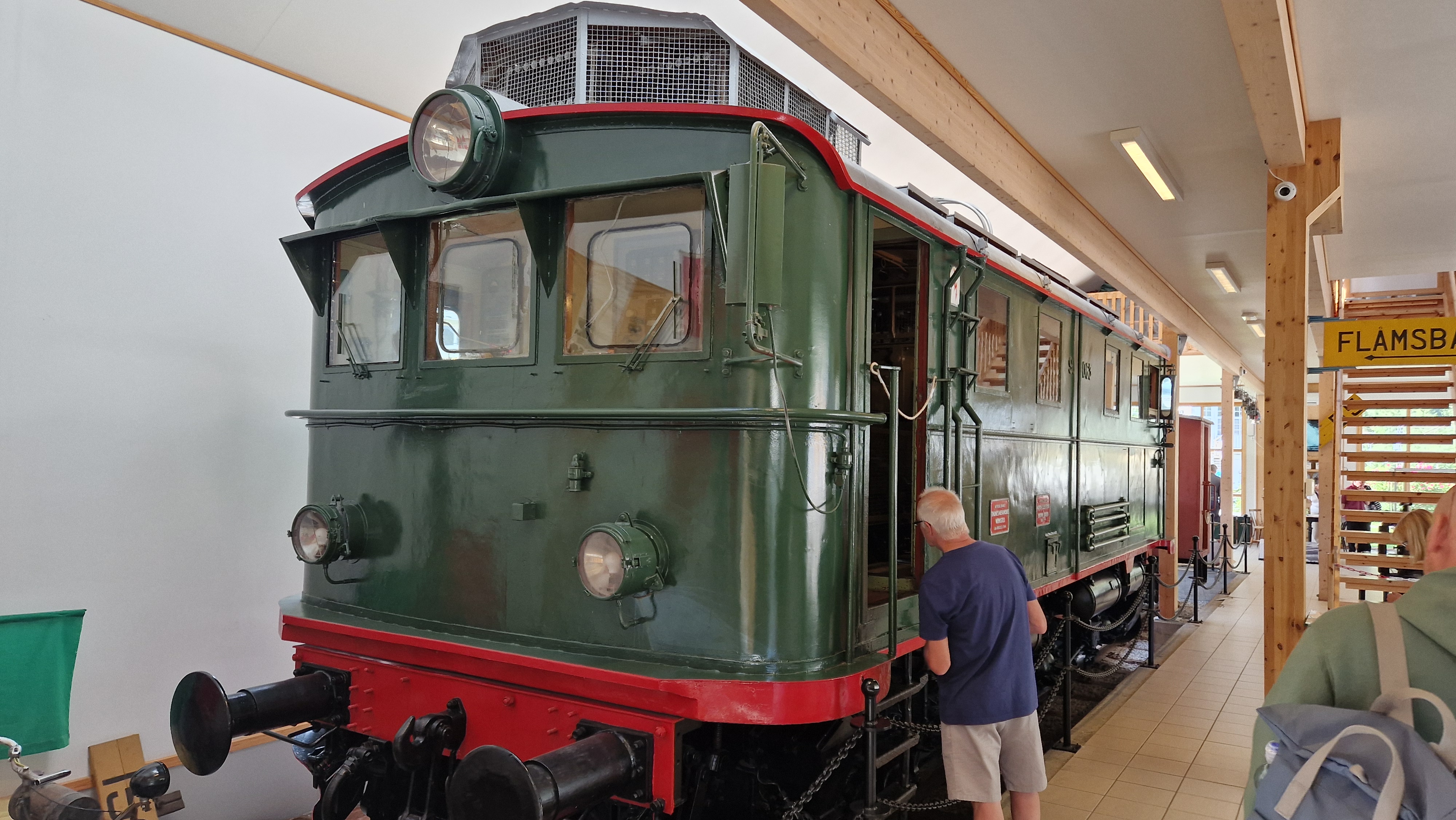
The Flåm Railway Museum has no entrance fee. The museum offers a guided tour, in 9 different languages, with an audio guide from Voice of Norway. After downloading the app on your mobile, you can experience the tour with an audio guide in the museum.
With a pleasant narration, you will hear about the construction of the Flåm Railway and the history of Flåm. At your own pace, on your own mobile, you will get to know the authentic exhibition at the museum.

At your own pace, on your own mobile, you will get to know the authentic exhibition at the museum.
We visit the Flåm Railway Museum and discover the exciting stories behind the construction of the Flåm Railway, Europe’s second steepest railway. Listen to the audiovisual guided tour, which tells you about the hardworking people who built this masterpiece of a railway. As well as the many technical challenges during construction.

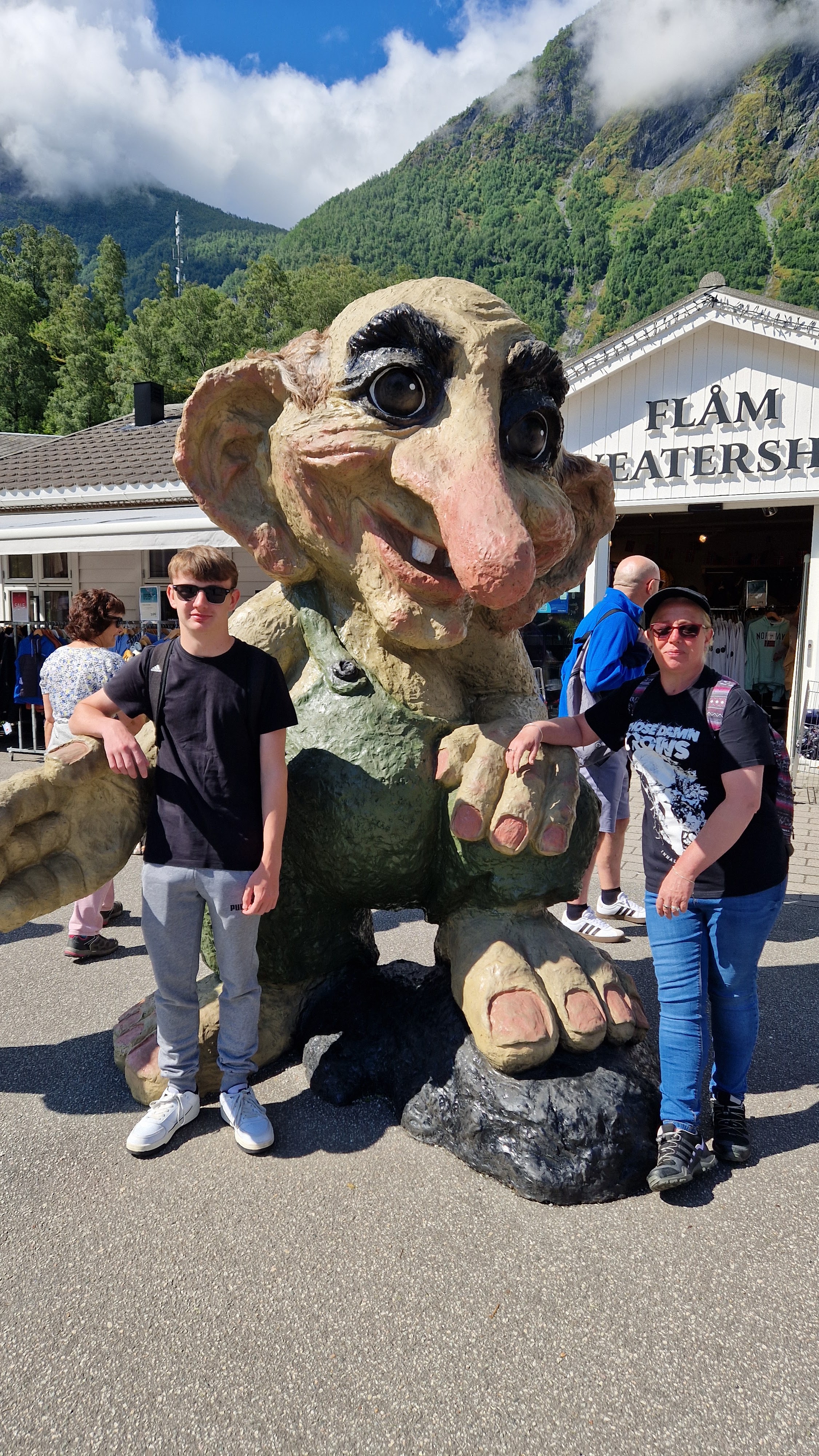
Almost next door to the museum is the Flåm Sweatershop, and outside we take photos with a giant Norwegian Troll.
Flåm Sweatershop is a delightful haven for tourists seeking authentic Norwegian craftsmanship. Located in the scenic village of Flåm, this charming clothing store specializes in high-quality sweaters and knitwear that embody the essence of Norway's rich textile traditions. As you step inside, you'll be greeted by the warm ambiance that reflects the cozy Norwegian lifestyle and the friendly staff eager to assist you in finding the perfect piece. The shop features an impressive array of sweaters, cardigans, and accessories, showcasing intricate designs inspired by nature and Norwegian folklore. Each item is crafted with care, ensuring that visitors not only take home a stylish souvenir but also a piece of cultural heritage.

A troll is a being in Nordic folklore, including Norse mythology. In Old Norse sources, beings described as trolls dwell in isolated areas of rocks, mountains, or caves, live together in small family units, and are rarely helpful to human beings.
In later Scandinavian folklore, trolls became beings in their own right, where they live far from human habitation, are not Christianized, and are considered dangerous to human beings. Depending on the source, their appearance varies greatly; trolls may be ugly and slow-witted, or look and behave exactly like human beings, with no particularly grotesque characteristic about them.
In Scandinavian folklore, trolls are sometimes associated with particular landmWe stop for a break on a picnic bench with views back to Iona, she looks beautiful sitting here in the fjord.arks (sometimes said to have been formed by a troll having been exposed to sunlight). Trolls are depicted in a variety of media in modern popular culture.

We stop for a break on a picnic bench with views back to Iona, she looks beautiful sitting here in the fjord.

We walk on and see the Flamsbana train sitting at the station, waiting to take the tourists on their journey. Flåm is heaving with tourists and on top of the cruise visitors many more coaches are arriving.

We decide its time to leave the hustle and bustle and start our walk to visit the Brekkenfossen waterfall.

We cross a bridge over the river Flåmselvi and walk along Nedre Brekkevegen and a campsite beside it.

The views are just jawdropping gorgeous.

Further up were a herd of cows that we had to stop and say Hi to.

The village of Flåm has since the late 19th century been a tourist destination. It currently receives almost 450,000 visitors a year. Most ride the 20-kilometre (12 mi) Flåm Line between Flåm and Myrdal, one of the steepest railway tracks at 1 in 18 (not counting rack railways) in the world. There are also a few spirals. A former rail station building in Flåm now houses a museum dedicated to the Flåm railway.

Getting a photo of one, I leant forward and not noticing a wire, I get a big shock from the electric fence, Mel and George heard the surge as I touched it!

There are complaints of overtourism and suggested curbs on it.
Air pollution in Flåm and Geiranger during the cruise season is similar to that of a big city. Cruise traffic in Norway, which is one of the largest exporters of oil in the world, emits more NOx than all road traffic in Norway combined.
In 2009, Jens Riisnæs (an author and NRK journalist) said "We have the world's most beautiful nation, we don't need to follow the cruise operators' premises. They can go other places with their polluting ships. It is unwanted noise."
In 2009, Dagens Næringsliv said that a report by Vestlandsforskning says that both "Flåm and Geiranger are nearing a limit in capacity. It might be an alternative and rather stand forth as a «relaxed», exclusive and somewhat less of a mass tourism, cruise destination."
In a 2014 Dagens Næringsliv article, a farmer said that "Previously the smell of summer was that of grass that had been cut. Now the smell is of heavy oil".] Furthermore, "They [a retired couple] talk about fish that has disappeared from the fjord. In Norway, cruise ships are permitted to dump overboard their greywater in the postcard-narrow fjord-arms. Furthermore, the news article says that defecation in public by tourists, is already a problem; the village's train station has the only public toilets, and 200,000 tourists are expected in the summer season.
In 2014, tourism professor Arvid Viken said that "it is about time this [type of] tourism is evaluated somewhat more soberly than how it has been done in many municipalities for some years". Furthermore, this tourism "has low profit per tourist, but is often associated with considerable costs for" the municipal administrations.

As we walked on further we can see the waterfall in the distance.

Flåm was the birthplace of the poet Per Sivle. I know, I’ve never heard of him either!

We have now found the footpath after about 1.5km of walking and we start climbing up.

Its okay at first but then gets steeper and turns to huge steps. Its tough going, glad we bought plenty of water each.

This hike is a total of 5 km in length (return from Flåm centre). Total climb in elevation about 155 m.

Mel looks like she wants to give up, its tough and very hot. But the many people coming down give encouragement and says it is well worth the climb, so we continue upwards.

After quite a walk we stop at a mini waterfall in the shade and I dip my cap in the cool water to cool myself off.


We continue on, we were so close at that stop as we are now here at the waterfall viewpoint.

Brekkefossen is a powerful waterfall in the south-middle of Norway at Flåm, municipality Aurland, in the region Sogn og Fjordane. Most people will see this waterfall along the Flåmbanen by train.

The views back down to Flåm and Iona sitting in the fjord was just amazing!

Brekkefossen. A powerful waterfall with an overall height of 100 metres, probably higher (800 metres) if you count in the rest of the river. Brekkefossen is fed by the rivers Ljosdøla/Brekkeelvi which has its origin at the Viddalsfjelett and Skratlandevatnet (lake) at an altitude of 1418 metres.


Brekkefossen was thundering and amazing from the small plateau on which numerous other hikers were resting and taking in the views. Gazing outwards and along the valley it was possible to trace the route we’d walked all the way back to Flåm and to see our cruise ship docked at the village port. Snow-topped mountains, fjords, a waterfall, wooden buildings nestled, wow!


The cooling spray from the waterfall was very welcoming.


We walked back the way we came and were soon back in Flåm. We walked up to the edge of the Fjord and to Flåm beach. Mel and George took a rest, while I took a dip in the Fjord.


It was cold, even by my standards. I wasn’t in for too long, but long enough to enjoy the scenery and take some photos!


We walk back and decide to to have a drink in the Viking hut themed pub, the Ægir microbrewery bar.

The wooden interior with its design reminiscent of stave churches or Viking halls , the chairs were amazing. Now how do I smuggle them out and aboard the Iona?


The beer was superb too with a range to suit all tastes.


I had aLærdøl Sour Cherry Rye(A crisp and tart thirst quencher),Mel had a Aegir Raspberry Pale Ale,(a pale, red and refreshingly tangy ale. The bitterness is well balanced against the redberry flavours from locally sourced raspberries taken from the foot of the Norwegian Fjord mountainside. Slightly tropical hop notes) and George opted for a cider.

Norway is pricey though and those 3 drinks came to £31!


We walked back onboard Iona and went straight for lunch, we were starving!

We set sail later that evening and on towards Haugseund our stop tomorrow.

We watched another strange show in the grand atrium before dinner later that night in the Opal Restaurant.

Goodbye Flåm,you were amazing!


